- All Categories (55)
- Data (1)
- News (15)
- Missions (1)
- Events (10)
- Tools (3)
- Activities (1)
- Documents (24)
Document - Conference Presentation - Poster
1-SAR-Derived High-Res-Operational-Wind-Products.pdf
SAR-Derived High-Resolution Operational Wind Products within NOAA CoastWatch William Pichel (NOAA/NESDIS, US)
Document - Conference Presentation - Poster
10_torano_TDX_boreal_classification_polinsar_2013.pdf
Boreal forest biomass classification with TanDEM-X A. Torano Caicoya [German Aerospace Center - DLR]
Document - Conference Presentation - Poster
1_Pardini_TDXtomography_Polinsar13.pdf
Towards Forest Vertical Structure Monitoring From Space: First Experiments With Multi-Baseline TanDEM-X Data M. Pardini [German Aerospace Center - DLR]
Document - Conference Presentation - Poster
1_POLinSAR2013_compact_v1.pdf
Time Series Decomposition Analysis for Compact Polarimetry S.R. Cloude [AEL Consultants - UK]
Document - Conference Presentation - Poster
2_POLinSAR2013_Hannevik_presentation.pdf
Combining polarimetric channels for better ship detection results T.N.A. Hannevik [Norwegian Defence Research Establishment - Norway]
Document - Conference Presentation - Poster
2_ppt_POLINSAR2013_dmonells_std.pdf
Performance Comparison between Dual Polarimetric and Fully Polarimetric data for DInSAR Subsidence monitoring D. Monells [Universitat Politecnica de Catalunya, UPC - Spain]
Event - Training
2nd Advanced Course on Radar Polarimetry 2013
The advanced ESA course provided an introduction to the basics and advanced concepts of theory, scattering concepts, systems and applications typical of radar polarimetric remote sensing.
Document - Conference Presentation - Poster
3_Kugler_TDX_PolInSAR_2013_final.pdf
Pol-InSAR Techniques Forest Characterisation with TanDEM-X F. Kugler [German Aerospace Center - DLR]
Document - Conference Presentation - Poster
3_leinss_polinSAR2013_v3.pdf
Snow property extraction based on polarimetry and differential SAR interferometry S. Leinss [ETH Zürich - Switzerland]
Document - Conference Presentation - Poster
4_POL_rig_dmon_polinsar.pdf
Phase Quality Optimisation Techniques and Limitations in Polarimetric Differential SAR Interferometry R. Iglesias [Universitat Politecnica de Catalunya, UPC - Spain]
Event - Training
4th Advanced Training Course in Land Remote Sensing
ESA organised the 4th Advanced Training Course in Land Remote Sensing which took place in Athens, Greece from 1 to 5 July 2013
Document - Conference Presentation - Poster
5-Ship-detection-motion-parameter-estimation-TanDEM-X.pdf
Ship detection and motion parameter estimation with TanDEM-X in large along-track baseline configuration Stefan Baumgartner (DLR, Germany)
Event - Training
5th Advanced Course on Radar Polarimetry 2019
The course was dedicated to training the next generation of EO scientists to exploit dual and fully polarimetric data for science and applications development.
News - Infographics
An overview of ESA's Third Party Missions programme
ESA’s Third Party Missions programme consists of almost 50 satellite missions, which are owned by organisations around the world. ESA has agreements with these organisations to acquire, process, and distribute data from their missions
News - Success Stories
Commercial and international data for fire monitoring
As climate change sparks a surge in the frequency and intensity of wildfires, satellite data disseminated through ESA’s Third Party Missions (TPM) programme are helping scientists to track and investigate these potentially damaging natural events.
Document - Conference Presentation - Poster
D3T3a_Schmullius_LTC2013.pdf
D3T3a Forest & Agriculture C. Schmullius
News - Success Stories
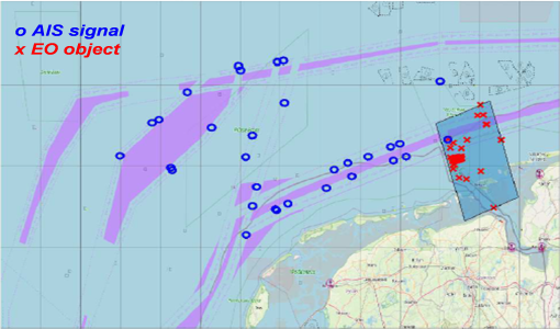
Earth Observation data to improve navigation risk modelling and shipping routes
With the increased frequency of shipping activities, such as tourism and transport of freights, navigation safety has become a major concern. Even if new technologies have already supplied aids to pilots for navigation risk reduction, the International Maritime Organisation (IMO) reports that the majority of accidents could have been avoided by providing suitable input to the navigation decision-making process — this is where Earth Observation data can represent complementary information, to improve traffic monitoring and guidance along safe routes.
Document - Newsletter
Earth Online Newsletter - 22 March 2024
This issue of the Earth Online Newsletter covers a selection of the latest news and events from ESA.
Document - Proceedings
EO-Summer-School-5-A-short-introduction-to-microwave-remote-sensing-of-the-land-surface.pdf
This presentation from ESA's EO Summer School 5 is a short introduction to microwave remote sensing of the land surface
Document - Proceedings
EO-Summer-School-8-Using-EO-to-understand-volcanic-processes.pdf
This presentation from ESA's EO Summer School 8 describes using EO for volcanoes


