- All Categories (33)
- Data (3)
- News (8)
- Missions (2)
- Events (10)
- Campaigns (2)
- Documents (8)
News - Events and Proceedings
Celebrating ESA’s first small satellite with science success
Scientists and data users gathered at a special workshop to celebrate the end of PROBA-1’s CHRIS sensor and discuss the results of this overachieving mission.
Event - Workshop

PROBA-1 CHRIS End of Mission Workshop
The PROBA-1 CHRIS End of Mission Workshop will take place from 18-19 January 2024 in Ghent, Belgium.
News - Infographics
Discover how RADARSAT scans Earth's surface
Learn about how RADARSAT scans Earth's surface in our new infographic.
News - Thematic area articles
Monitoring water on Earth's surface
ESA's Earth observation satellites are playing a leading role in furthering our understanding of how Earth's terrestrial hydrosphere is being influenced by humankind.
News - Infographics

PROBA-1 - From technology demonstration to long-term Earth observation
Learn about ESA's PROBA-1 (Project for On-Board Autonomy) mission in our new infographic.
News - Infographics

An overview of ESA's Third Party Missions programme
ESA’s Third Party Missions programme consists of almost 50 satellite missions, which are owned by organisations around the world. ESA has agreements with these organisations to acquire, process, and distribute data from their missions
News - Events and Proceedings

Φ-Week Triumphs
In its fourth edition, Φ-Week presented the scientific community with amazing opportunities and projects—thus running alongside innovation at 360 degrees.
News - Data Release news
RADARSAT-2 ESA archive online collection
The RADARSAT-2 ESA archive collection is now available on TPM LOADS Dissemination server.
News - Data Release news

RADARSAT data on demand
In the framework of the Earthnet programme, ESA is distributing RADARSAT data on-demand to support EO science and research activities.
Event - Workshop

POLinSAR 2013
The objectives of the PolInSAR 2013 workshop were to present the latest studies and results of SAR polarimetry and polarimetric interferometry.
Data - EO Sign In Authentication (Open)
PROBA-1 HRC
The HRC Level 1A product is an image with a pixel resolution of 8m. The data are grey scale images, an image contains 1026 x 1026 pixels and covers an area of 25 km2. HRC data is supplied in BMP format. All PROBA-1 passes are systematically acquired according to the current acquisition plan, HRC data are processed every day to Level 1A and made available to ESA users. Spatial coverage: Check the spatial coverage of the collection on a map available on the Third Party Missions Dissemination Service.
Data - EO Sign In Authentication (Open)
PROBA-1 CHRIS Level 1A
CHRIS acquired a set of up to five images of each target during each acquisition sequence, these images were acquired when PROBA-1 was pointing at distinct angles with respect to the target. CHRIS Level 1A products (supplied in HDF data files, version 4.1r3) include five formal CHRIS imaging modes, classified as modes 1 to 5: Mode Name Swath Spectral Bands/Ground Resolution Mode 1 Aerosols 13 km 62 at 34 m (773 nm / 1036 nm) Mode 2 Water bands 13 km 18 at 18 m Mode 3 Land channels 13 km 18 at 18 m Mode 4 Chlorophyll band set 13 km 18 at 18 m Mode 5 Land channels 6.5 km 37 at 18 m Spatial coverage: Check the spatial coverage of the collection on a map available on the Third Party Missions Dissemination Service.
Mission - Third Party Missions

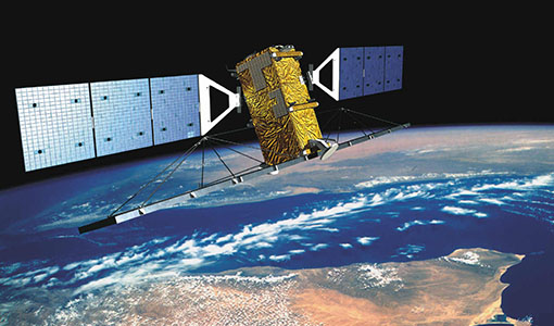
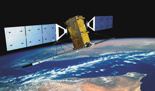
PROBA-1
PROBA-1 is a technology demonstration satellite that later became an operational Earth observation mission.
Data - Campaigns (Open)

AgriSAR 2009
The AgriSAR 2009 campaign was defined to leverage the RADARSAT-2 mission to better understand and demonstrate the potential for GMES land monitoring user services, particularly in agriculture.
Campaign
AgriSAR 2009
The AgriSAR 2009 campaign was defined to leverage the RADARSAT-2 mission to better understand and demonstrate the potential for GMES land monitoring user services, particularly in agriculture.
Campaign

SPARC
ESA's SPectra bARrax Campaign (SPARC) activity was part of the preparatory study for a proposed ESA Earth Explorer mission called SPECTRA. The objective was to collect a CHRIS/PROBA reference dataset for SPECTRA-related studies.
Mission - Heritage Missions
RADARSAT
The RADARSAT programme consists of a pair of remote sensing satellites from the Canadian Space Agency (CSA).
Event - Conference

IGARSS 2019
World-class scientists, engineers and educators in geoscience and remote sensing gathered in Yokohama, Japan, for the 39th annual IGARSS symposium.
Event - Training

5th Advanced Course on Radar Polarimetry 2019
The course was dedicated to training the next generation of EO scientists to exploit dual and fully polarimetric data for science and applications development.
Event - Workshop

POLinSAR 2009
The 2009 workshop focused on theory and methods in the fields of SAR Polarimetry and Polarimetric Interferometry