- All Categories (1293)
- Data (12)
- News (20)
- Missions (3)
- Events (12)
- Tools (7)
- Activities (4)
- Campaigns (1)
- Documents (1234)
News - Success Stories
10 years of Envisat data help to illuminate ocean processes
A decade after Envisat beamed its final image to the planet, the pioneering ESA mission is continuing to foster improved understanding of Earth’s systems.
Document - General Reference
141022-RMA-03-data-consistency.pdf
ERS-2 ASCAT Data Consistency presentation
Document - General Reference
150604-RMA-01-ERS1-calibration-reprocessing-v2.pdf
ERS1-calibration-reprocessing-v2
Event - Workshop
2nd CHRIS PROBA Workshop
This 2004 workshop was on the treatment of Compact High Resolution Images Spectrometer (CHRIS) data.
Event - Training
3rd Advanced Training Course on Land Remote Sensing 2011
This 2011 advanced ESA training course focused on land remote sensing theory and applications.
Event - Workshop
3rd CHRIS PROBA Workshop
This 2005 workshop was on the treatment of Compact High Resolution Images Spectrometer (CHRIS) data.
Event - Workshop
4th CHRIS PROBA Workshop
Workshop on the treatment of Compact High Resolution Images Spectrometer (CHRIS) data.
News - Success Stories
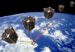
A long way for a little satellite
The PROBA-1 satellite, a technology demonstrator later turned into an Earth observation mission – and just a cubic metre in volume – is reaching 20 years of continuity, making it a huge success.
News - Infographics
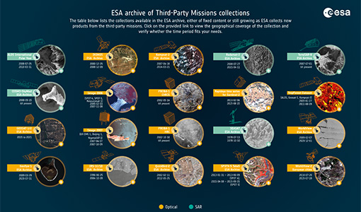
A summary of ESA Third Party Mission collections
A new summary is available, showcasing the ESA archives for Third Party Mission collections.
Document - Technical Note
A-comparison-of-superresolution-reconstruction-methods-for-multiangle-CHRIS-Proba-images.pdf
This paper presents the results of three superresolution methods applied to multiangular CHRIS/Proba data: three methods, namely non-uniform interpolation and de-convolution, iterative back-projection, and total variation are examined.
Document - Product Document
Access to Envisat Data
The scope of this document is to focus on the data dissemination methods and the different means offered to Users to access the Envisat data.
Event - Training
Advanced Training Course in Land Remote Sensing 2012
The 2012 advanced training course focused on land remote sensing theory and applications.
Document - Proceedings
Advances-in-Atmospheric-Science-and-Applications.pdf
Proceedings in Advances in Atmospheric Science and Applications held in 18-22 June 2012 in Bruges, Belgium.
Document - Publication - Paper
Assessment of Canopy Structure and Heterogeneity from Multi-Angular CHRIS-PROBA Data
The spaceborne ESA-mission CHRIS-PROBA (Compact High Resolution Imaging Spectrometer-Project for On-board Autonomy) provides hyperspectral and multi-angular data of selected terrestrial targets (Barnsley et al. 2004). For vegetated surfaces, the spectral information content of CHRIS data may yield the biochemical and biophysical properties of a vegetation canopy, while the directional component may deliever additional information on its canopy structure. Here, the multi-angular CHRIS observations are investigated and related to surface structure using the parametric RahmanPinty-Verstraete (RPV) model.
Data - EO Sign In Authentication (Open)
Atmospheric Thematic Data Product [MWR_TDPATM]
This is the Atmospheric Thematic Data Product (TDP) V1 resulting from the ESA FDR4ALT project and containing Total Column Water Vapour (TCWV), Cloud Liquid Water Path (LWP), Atmospheric Attenuation of the altimeter backscattering coefficient at Ku-band (AttKu), and Wet Tropospheric Correction (WTC), retrieved from observations of the Microwave Radiometer (MWR) instruments flown on-board the ERS-1, and ERS-2, and Envisat satellites. Compared to existing datasets, the Atmospheric TDP demonstrates notable improvements in several aspects: Improved temporal coverage, especially for ERS-2 Improved L0 -> 1 processing Two different corrections are provided based on a neural network retrieval or on a 1D-VAR approach The FDR4ALT products are available in NetCDF format. Free standard tools for reading NetCDF data can be used. Information for expert altimetry users is also available in a dedicated NetCDF group within the products. Please consult the FDR4ALT Product User Guide before using the data. The FDR4ALT datasets represent the new reference data for the ERS/Envisat altimetry missions, superseding any previous mission data. Users are strongly encouraged to make use of these datasets for optimal results.
Document - General Reference
Autonomy-in-action-Ten-years-of-Proba-1.pdf
This is an article extracted from the ESA Bulletin Nr.148.
Document - General Reference
Big-year-for-small-satellite-ESAs-second-in-orbit-technology-demonstration-mission-Proba-2.pdf
This is an article extracted from the ESA Bulletin Nr.144.


