- All Categories (45)
- Data (14)
- News (11)
- Missions (3)
- Events (9)
- Tools (2)
- Activities (4)
- Documents (2)
Activity - Projects
Swarm Outflow
The Swarm+ Coupling High-Low Atmosphere Interactions: Ion Outflow ("Swarm+ Outflow") project, which began in May 2019, centres on using Swarm spacecraft to tackle unanswered questions around non-thermal processes that lead to ion outflow.
News - Thematic area articles
Space data help to unravel the complexities of Earth’s atmosphere
As the impacts of the climate crisis intensify, scientists are using ESA’s Earth observation archives to investigate atmospheric processes and their influences on the planet’s changing environment.
Data - EO Sign In Authentication (Open)
SeaSat ESA archive
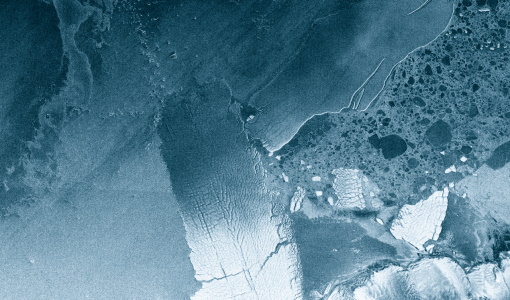
This collection gives access to the complete SEASAT dataset acquired by ESA and mainly covers Europe. The dataset comprises some of the first ever SAR data recorded for scientific purposes, reprocessed with the most recent processor. The Level-1 products are available as: SAR Precision Image [SEA_PRI_1P] SAR Single Look Complex Image [SEA_SLC_1P] SAR Ellipsoid Geocoded Precision Image [SEA_GEC_1P] Spatial coverage: Check the spatial coverage of the collection on a map available on the Third Party Missions Dissemination Service.
Document - Proceedings
SEASAR-2012-sessions-summaries-seed-questions-recommendations.pdf
This document gathers together the sessions summaries with seed questions discussion and recommendations of the SEASAR 2012 workshop.
Event - Workshop
SEASAR 2012
The European Space Agency and the Norwegian Space Centre jointly organised the fourth SAR oceanography workshop, 'SEASAR 2012', entitled 'Advances in SAR Oceanography'.
Event - Workshop
SEASAR 2008
The "Advances in SAR Oceanography from Envisat and ERS missions" was a thematic workshop on SAR remote sensing techniques for oceanography.
Event - Workshop
SEASAR 2006
ESA organised it's first SAR oceanography workshop, SEASAR 2006, entitled "Advances in SAR Oceanography from Envisat and ERS missions"
Activity - Projects
Plasmapause Related boundaries in the topside Ionosphere as derived from Swarm Measurements
In the project, Plasmapause Related boundaries in the topside Ionosphere as determined from Swarm Measurements (PRISM), the team develop products that characterise position of the plasmapause related phenomena in the topside ionosphere.
Data - EO Sign In Authentication (Open)
Ocean Waves Thematic Data Product [ALT_TDP_WA]
This is the Ocean Waves Thematic Data Product (TDP) V1 resulting from the ESA FDR4ALT project and containing Significant Wave Height estimates for the ERS-1, ERS-2 and Envisat missions. Compared to existing datasets, the Ocean Waves TDP demonstrates notable improvements in several aspects: Great improvements for Envisat due to noise reduction from Adaptive retracker and High-Frequency Adjustment (HFA) All variables are given at 5 Hz The FDR4ALT products are available in NetCDF format. Free standard tools for reading NetCDF data can be used. Information for expert altimetry users is also available in a dedicated NetCDF group within the products. Please consult the FDR4ALT Product User Guide before using the data. The FDR4ALT datasets represent the new reference data for the ERS/Envisat altimetry missions, superseding any previous mission data. Users are strongly encouraged to make use of these datasets for optimal results.
News - Data Release news
New ERS-2 GOME Level 1 v5.1 dataset available online
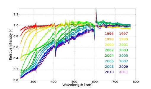
A new GOME Level 1b dataset has been generated for the 16-year mission period bringing relevant quality improvements for the revised calibration approach, compensating aging and instrument degradation, and provide enhanced accessibility.
News - Success Stories
New CryoSat data to boost understanding of the oceans
A new CryoSat sea level anomaly product designed to enable ocean science and the development of operational marine applications has been released.
Event - Conference
Living Planet Symposium 2019
ESA's Living Planet Symposia are amongst the biggest Earth observation conferences in the world. Scientists present their latest findings on Earth's environment and climate.
News - General News
Launch of Aeolus VRE
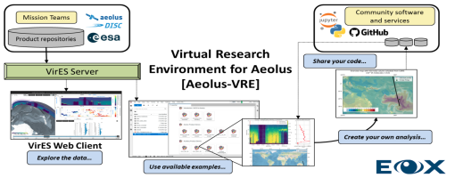
The Aeolus Virtual Research Environment (VRE) is a cloud service, which provides users with a web-based development environment in the form of a JupyterLab workspace.
Data - EO Sign In Authentication (Open)
JERS-1 SAR Level 1 Single Look Complex Image
The JSA_SLC_1P product is comparable to the ESA SLC/IMS images generated for Envisat ASAR and ERS SAR instruments. It is a slant-range projected complex image in zero-Doppler SAR coordinates. The data is sampled in natural units of time in range and along track, with the range pixel spacing corresponding to the reciprocal of the platform ADC rate and the along track spacing to the reciprocal of the PRF. Data is processed to an unweighted Doppler bandwidth of 1000Hz, without sidelobe reduction. The product is suitable for interferometric, calibration and quality analysis applications. Data acquired by ESA ground stations. Spatial coverage: Check the spatial coverage of the collection on a map available on the Third Party Missions Dissemination Service.
Data - EO Sign In Authentication (Open)
JERS-1 SAR Level 1 Precision Image
The JSA_PRI_1P product is comparable to the ESA PRI/IMP images generated for Envisat ASAR and ERS SAR instruments. It is a ground range projected detected image in zero-Doppler SAR coordinates, with a 12.5 metre pixel spacing. It has four overlapping looks in Doppler covering a total bandwidth of 1000Hz, with each look covering a 300Hz bandwidth. Sidelobe reduction is applied to achieve a nominal PSLR of less than -21dB. The image is not geocoded, and terrain distortion (foreshortening and layover) has not been removed. Data acquired by ESA ground stations. Spatial coverage: Check the spatial coverage of the collection on a map available on the Third Party Missions Dissemination Service.
News - Success Stories
How Envisat helped to shape global understanding of Earth’s systems
Twenty years have passed since a ground-breaking European spacecraft designed to deliver unprecedented insight into the planet’s changing environment was lofted into orbit.
Tools - Apps
Heritage Missions app for iOS
Download the Heritage Missions application to discover what the missions were about, how it worked and what the elements of the space and ground segment that make these missions unique.
News - Events and Proceedings
Exploring the prevailing achievements and future directions of Aeolus
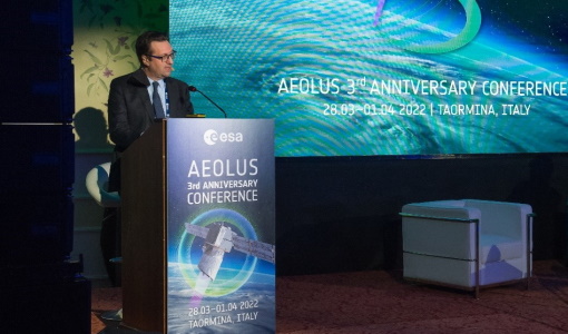
A tight-knit community of European remote sensing experts converged on the Italian island of Sicily last month to discuss how the strong success of ESA’s Aeolus mission is shaping scientists’ understanding of the winds that sweep across the planet.
Activity - Projects
ESA's multi-level global thermosphere data products consistent with Swarm and GRACE (-FO)
In this project, the possibility of using the space-based along-track Thermospheric Neutral Density (TND) estimates for generating the European Space Agency (ESA)'s Level 3 (L3) global multi-level TND data products is assessed.
News - Data Release news
ESA's (A)SAR dissemination service enhanced with Envisat ASAR MR L1 data
With integration of four additional Envisat ASAR Level 1 collections, ESA is now providing access to the complete Envisat and ERS (A)SAR imagery data archive via the ESA (A)SAR Online Dissemination service.


