- All Categories (24845)
- Data (12)
- News (82)
- Missions (5)
- Events (16)
- Tools (8)
- Activities (3)
- Campaigns (9)
- Documents (24710)
Event - Conference

15 Years of Progress in Radar Altimetry Symposium
A Symposium on "15 Years of Progress in Radar Altimetry" and the annual meeting of the Ocean Surface Topography Science Team, the International Doris Service Workshop and the ARGO Workshop.
Document - Proceedings

2004 Envisat and ERS Symposium
The 2004 Envisat and ERS Symposium was held in Salzburg - Austria from 6 to 10 September 2004. The 2004 Envisat and ERS Symposium provided a forum for investigators to present results of ongoing research project activities and assess the development of applications and services.
News - Data Release news

2011 CryoSat Ice Baseline D reprocessed data available
We are pleased to inform the CryoSat scientific community that the reprocessed CryoSat Ice Baseline D data for all of 2011 has been published on the Science Server and is available for download.
News - Data Release news

2012 CryoSat Ice Baseline D reprocessed data now available
We're pleased to inform the CryoSat scientific community that the reprocessed CryoSat Ice Baseline D data for all of 2012 has been published on the Science Server and is now available for download.
Document - General Reference

2013 Dragon 3 Brochure
The 2013 Dragon 3 cooperation brochure presents the activities undertaken since the formal start of programme in June 2012.
News - Data Release news
2014 CryoSat Ice Baseline D reprocessed data available
Reprocessed CryoSat Ice Baseline D data for all 2014 has been published on the Science Server and is available for download.
News - Data Release news
2015 CryoSat Ice Baseline D reprocessed data now available
The reprocessed CryoSat Ice Baseline D data for all of 2015 has now been published on the Science Server.
News - Data Release news

2016 CryoSat Ice Baseline D reprocessed data now available
The reprocessed CryoSat Ice Baseline D data for 2016 has now been published on the Science Server.
News - Data Release news
2017 CryoSat Ice Baseline D reprocessed data available
The reprocessed CryoSat Ice Baseline D data for all of 2017 is now available for download.
News - Data Release news

2018 CryoSat Ice Baseline D reprocessed data now available
Reprocessed CryoSat Ice Baseline D data for all of 2018 is now available.
Event - Meeting

20th GHRSST Science Team Meeting
The 20th GHRSST International Science Team meeting in 2019 brought together sea surface temperature experts to look at future innovations.
Event - Training

2nd Advanced Training Course on Ocean Remote Sensing 2009
This advanced training course focused on ocean remote sensing theory and applications.
Event - Training
3rd Advanced Training Course on Land Remote Sensing 2011
This 2011 advanced ESA training course focused on land remote sensing theory and applications.
Event - Training

3rd Advanced Training Course on Ocean Remote Sensing 2013
The 3rd Advanced Training Course on Ocean Remote Sensing was held from 23 to 27 September 2013 in Cork, at the National Maritime College of Ireland.
Event - Workshop

3rd International GOCE User Workshop
This workshop focussed on the oceanographic applications, such as absolute dynamic topography, of GOCE data in conjunction with other space-borne data, such as radar altimetry, and in-situ data and models.
News - Operational News
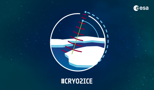
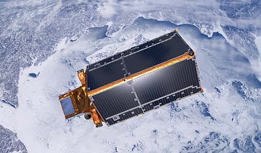
A Closer Look at CRYO2ICE Manoeuvres
Between 16 and 31 July 2020, ESA raised the orbit of Earth Explorer CryoSat-2 to periodically align with NASA’s ICESat-2 in a campaign dubbed CRYO2ICE.
Document - Technical Note

Accurate-Delta-Times-PATN-file-format.pdf
This document describes the PATN file, which is used for determining time correlation for ERS Radar Altimeter off-line processing.
Event - Training
Advanced Training Course in Land Remote Sensing 2012
The 2012 advanced training course focused on land remote sensing theory and applications.
Event - Training
Advanced Training Course in Ocean Remote Sensing 2011
Within the framework of the Dragon Programme, a joint collaboration between the European Space Agency (ESA) and the Chinese Ministry of Science and Technology (MOST), ESA and NRSCC are providing a series of advanced thematic training courses on remote sensing applications hosted by university and research institutions in P.R. China.