- All Categories (395)
- Data (11)
- News (49)
- Missions (3)
- Events (18)
- Tools (10)
- Activities (5)
- Campaigns (3)
- Documents (296)
Document - Technical Note

WorldView-GeoEye-QuickBird-Terms-Of-Applicability.pdf
This document contains the Terms of Applicability and Terms and Conditions for use of the WorldView 1-4, GeoEye 1 and QuickBird satellite data for Category 1 use.
News - Success Stories
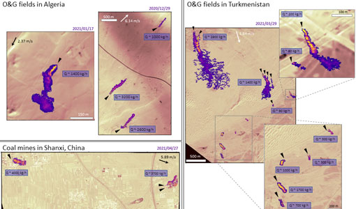
WorldView-3 satellite maps methane plumes at very high spatial resolution
Substantial advances have been made in the last years towards the detection and quantification of methane emissions from space- very high spatial resolution data from the WorldView-3 satellite can fill an important observational gap in the remote sensing of methane point emissions.
Data - Sample Data (Open)
WorldView-3 Sample Data
Download free WorldView-3 sample datasets to preview products available for this mission.
News - Success Stories

WorldView-3 helps to track offshore methane plumes from oil and gas
Scientists have used Earth observation data to reveal enormous methane plumes spilling out from an offshore oil and gas production rig in the Gulf of Mexico. This represents a significant breakthrough in the monitoring of industrial methane emissions from space.
Data - Project Proposal (Restrained)

WorldView-3 full archive and tasking
WorldView-3 high resolution optical products are available as part of the Maxar Standard Satellite Imagery products from the QuickBird, WorldView-1/-2/-3/-4, and GeoEye-1 satellites. All details about the data provision, data access conditions and quota assignment procedure are described into the Terms of Applicability available in Resources section. In particular, WorldView-3 offers archive and tasking panchromatic products up to 0.31m GSD resolution, 4-Bands/8-Bands products up to 1.24 m GSD resolution, and SWIR products up to 3.70 m GSD resolution. Band Combination Data Processing Level Resolution High Res Optical: Panchromatic and 4-bands Standard(2A)/View Ready Standard (OR2A) 15 cm HD, 30 cm HD, 30 cm, 40 cm, 50/60 cm View Ready Stereo 30 cm, 40 cm, 50/60 cm Map Ready (Ortho) 1:12.000 Orthorectified 15 cm HD, 30 cm HD, 30 cm, 40 cm, 50/60 cm High Res Optical: 8-bands Standard(2A)/View Ready Standard (OR2A) 30 cm, 40 cm, 50/60 cm View Ready Stereo 30 cm, 40 cm, 50/60 cm Map Ready (Ortho) 1:12.000 Orthorectified 30 cm, 40 cm, 50/60 cm High Res Optical: SWIR Standard(2A)/View Ready Standard (OR2A) 3.7 m or 7.5 m (depending on the collection date) Map Ready (Ortho) 1:12.000 Orthorectified 4-Bands being an optional from: 4-Band Multispectral (BLUE, GREEN, RED, NIR1) 4-Band Pan-sharpened (BLUE, GREEN, RED, NIR1) 4-Band Bundle (PAN, BLUE, GREEN, RED, NIR1) 3-Bands Natural Colour (pan-sharpened BLUE, GREEN, RED) 3-Band Colored Infrared (pan-sharpened GREEN, RED, NIR1) 8-Bands being an optional from: 8-Band Multispectral (COASTAL, BLUE, GREEN, YELLOW, RED, RED EDGE, NIR1, NIR2) 8-Band Bundle (PAN, COASTAL, BLUE, GREEN, YELLOW, RED, RED EDGE, NIR1, NIR2) Native 30 cm and 50/60 cm resolution products are processed with MAXAR HD Technology to generate respectively the 15 cm HD and 30 cm HD products: the initial special resolution (GSD) is unchanged but the HD technique increases the number of pixels and improves the visual clarity achieving aesthetically refined imagery with precise edges and well reconstructed details. As per ESA policy, very high-resolution imagery of conflict areas cannot be provided.
Mission - Third Party Missions
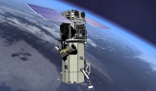
WorldView-3
WorldView-3 is the first multi-payload, super-spectral, high-resolution commercial satellite sensor operating at an altitude of 617 km. WorldView-3 is capable of collecting up to 680,000 square km per day.
Mission - Third Party Missions

WorldView Series
The WorldView constellation are environment-monitoring satellites that have been supplying imagery since 2007.
Data - Fast Registration with approval (Restrained)

WorldView ESA archive
The WorldView ESA archive is composed of products acquired by WorldView-1, -2, -3 and -4 satellites and requested by ESA supported projects over their areas of interest around the world Panchromatic, 4-Bands, 8-Bands and SWIR products are part of the offer, with the resolution at Nadir depicted in the table. Band Combination Mission GSD Resolution at Nadir GSD Resolution (20° off nadir) Panchromatic WV-1 50 cm 55 cm WV-2 46 cm 52 cm WV-3 31 cm 34 cm WV-4 31 cm 34 cm 4-Bands WV-2 1.84 m 2.4 m WV-3 1.24 m 1.38 m WV-4 1.24 m 1.38 m 8-Bands WV-2 1.84 m 2.4 m WV-3 1.24 m 1.38 m SWIR WV-3 3.70 m 4.10 m The 4-Bands includes various options such as Multispectral (separate channel for Blue, Green, Red, NIR1), Pan-sharpened (Blue, Green, Red, NIR1), Bundle (separate bands for PAN, Blue, Green, Red, NIR1), Natural Colour (pan-sharpened Blue, Green, Red), Coloured Infrared (pan-sharpened Green, Red, NIR). The 8-Bands being an option from Multispectral (COASTAL, Blue, Green, Yellow, Red, Red EDGE, NIR1, NIR2) and Bundle (PAN, COASTAL, Blue, Green, Yellow, Red, Red EDGE, NIR1, NIR2). The processing levels are: Standard (2A): normalised for topographic relief View Ready Standard: ready for orthorectification (RPB files embedded) View Ready Stereo: collected in-track for stereo viewing and manipulation (not available for SWIR) Map Scale (Ortho) 1:12,000 Orthorectified: additional processing unnecessary Spatial coverage: Check the spatial coverage of the collection on a map available on the Third Party Missions Dissemination Service. The following table summarises the offered product types EO-SIP Product Type Band Combination Processing Level Missions WV6_PAN_2A Panchromatic (PAN) Standard/View Ready Standard WorldView-1 and 4 WV6_PAN_OR Panchromatic (PAN) View Ready Stereo WorldView-1 and 4 WV6_PAN_MP Panchromatic (PAN) Map Scale Ortho WorldView-1 and 4 WV1_PAN__2A Panchromatic (PAN) Standard/View Ready Standard WorldView-2 and 3 WV1_PAN__OR Panchromatic (PAN) View Ready Stereo WorldView-2 and 3 WV1_PAN__MP Panchromatic (PAN) Map Scale Ortho WorldView-2 and 3 WV1_4B__2A 4-Band (4B) Standard/View Ready Standard WorldView-2, 3 and 4 WV1_4B__OR 4-Band (4B) View Ready Stereo WorldView-2, 3 and 4 WV1_4B__MP 4-Band (4B) Map Scale Ortho WorldView-2, 3 and 4 WV1_8B_2A 8-Band (8B) Standard/View Ready Standard WorldView-2 and 3 WV1_8B_OR 8-Band (8B) View Ready Stereo WorldView-2 and 3 WV1_8B_MP 8-Band (8B) Map Scale Ortho WorldView-2 and 3 WV1_S8B__2A SWIR Standard/View Ready Standard WorldView-3 WV1_S8B__MP SWIR Map Scale Ortho WorldView-3 As per ESA policy, very high-resolution imagery of conflict areas cannot be provided.
Document - General Reference

WATS - Water Vapour and Temperature in the Troposphere and Stratosphere.pdf
This report describes the WATS mission, one of the candidate Earth Explorers in the second cycle in 2001.
Document - Technical Note
WALES - Water Vapour Lidar Experiment in Space
This report describes the WALES mission, one of the candidate Earth Explorers in the second cycle in 2001.
Data - EO Sign In Authentication (Open)

VT GOCE Data
This collection contains the VT GOCE software and associated data set needed to run the software that is used for GOCE data visualisation.
News - Data Release news
Version 2.0 of GOCE thermosphere reprocessed data released
Version 2.0 of the GOCE thermosphere dataset is now available on the GOCE Online Dissemination Service.
Document - Software Verification Plan/Report

User Toolbox Requirements Document - GOCE User Toolbox Specifications (GUTS)
Deliverable: WP2000: This document provides user requirement for the GOCE User Toolbox, designed around the GOCE mission.
Document - General Reference
Understanding our Planet - the Earth Observation Envelope Program
This brochure describes the Earth Observation Envelope Programme.
Document - General Reference
Understanding climate change from space
This document describes ESA's Climate Change Initiative, and how it is intended to contribute towards monitoring and understanding the Earth's climate.
Document - General Reference
Towards the Definitive Space Gravity Mission
This article appeared on the International WOCE Newsletter, issue nr. 33 published on December 1998.
Document - General Reference
Towards More Efficient Use of Radar-Altimeter Data
Twenty years ago, experimental altimeters on NASA's Skylab and Geos-3 were already demonstrating the potential of such instrumentation. This led in turn to the development and launch by NASA in July 1978 of the Seasat oceanographic satellite mission. Both Geos-3 and Seasat were very successful in their pioneering missions, but were limited somewhat by poor coverage in the case of Geos-3 and an abnormally short mission duration in Seasat's case.
Document - Software Verification Plan/Report
Toolbox Functionality and Algorithm Specification Document - GOCE User Toolbox Specifications (GUTS)
Deliverable: WP3000: This report is the output from WP3000 of the GOCE User Toolbox Specification. The study will select the best (in terms of accuracy and computational demands) algorithms to compute the variables listed in the user requirement document [1]. This document will form the basis for the system specification work performed in WP4000 and the prototype and tutorials to be generated in WP5000, all available in this library.
Activity - Projects

TOLEOS
The TOLEOS (Thermosphere Observations from Low-Earth Orbiting Satellites) project will produce thermosphere mass density observations from the accelerometer measurements of the GRACE, GRACE-FO, and CHAMP satellites.
News - Infographics

Timeline to over 40 years of historical satellite missions
ESA's Heritage Space Programme preserves historical data from over 40 years of Earth observation missions.