- All Categories (443)
- Data (12)
- News (47)
- Missions (2)
- Events (33)
- Tools (12)
- Activities (6)
- Campaigns (4)
- Documents (327)
News - Events and Proceedings

Φ-Week Triumphs
In its fourth edition, Φ-Week presented the scientific community with amazing opportunities and projects—thus running alongside innovation at 360 degrees.
Document - Product Specifications

WorldDEM4Ortho-Technical-Specification.pdf
This document describes the specification and format of the TerraSAR-X/TandEM-X WorldDEM4Ortho product. It provides a description of the processing steps, the characteristics of the product as well as the delivery formats.
Document - Product Specifications
WorldDEM-Technical-Specification.pdf
This document describes the specification and format of the TerraSAR-X/TanDEM-X WorldDEM(TM) product portfolio. It provides a description of the post-processing (editing) process, the characteristics of the Digital Elevation Models and the ancillary data that are collected and/or generated during the data finishing process as well as the delivery formats.
Document - Product Specifications
WorldDEM-Product-Specification-Summary.pdf
This document summarises the WorldDEM product from TerraSAR-X/TanDEM-X data, offered by Airbus.
Document - Product Specifications
WorldDEM-DTMlite-Technical-Specification.pdf
This document describes the specification and format of the TerraSAR-X/TanDEM-X WorldDEM DTMlite product. It provides a description of the processing steps, the characteristics of the product as well as the delivery formats.
Document - General Reference

WATS - Water Vapour and Temperature in the Troposphere and Stratosphere.pdf
This report describes the WATS mission, one of the candidate Earth Explorers in the second cycle in 2001.
Document - Technical Note

WALES - Water Vapour Lidar Experiment in Space
This report describes the WALES mission, one of the candidate Earth Explorers in the second cycle in 2001.
Data - EO Sign In Authentication (Open)

VT GOCE Data
This collection contains the VT GOCE software and associated data set needed to run the software that is used for GOCE data visualisation.
Event - Meeting

VH-RODA and CEOS SAR workshop
The workshop provided an open forum for the presentation and discussion of current status and future developments related to the calibration and validation of space borne very high-resolution SAR and optical sensors and data products.
News - Data Release news
Version 2.0 of GOCE thermosphere reprocessed data released
Version 2.0 of the GOCE thermosphere dataset is now available on the GOCE Online Dissemination Service.
Document - Software Verification Plan/Report

User Toolbox Requirements Document - GOCE User Toolbox Specifications (GUTS)
Deliverable: WP2000: This document provides user requirement for the GOCE User Toolbox, designed around the GOCE mission.
Event - Conference

User Consultation for Infrastructures Planning and Monitoring Conference 2019
ESA hosted a joint DLR/ESA user consultation for infrastructures planning and monitoring conference on 26 and 27 February 2019.
Document - General Reference
Understanding our Planet - the Earth Observation Envelope Program
This brochure describes the Earth Observation Envelope Programme.
Document - General Reference
Understanding climate change from space
This document describes ESA's Climate Change Initiative, and how it is intended to contribute towards monitoring and understanding the Earth's climate.
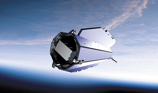
News - Infographics
Twin satellites - TerraSAR-X and TanDEM-X
DLR's TerraSAR-X and TanDEM-X are twin satellites flying in close formation to acquire SAR data of unique geometric accuracy. Operating together, the missions deliver data that are used to generate Digital Elevation Models of Earth.
Document - Technical Note
TSX-TDX-Terms-Of-Applicability.pdf
This file contains the Terms of Applicability and Terms and Conditions for using TanDEM-X and TeraSAR-X data.
Document - User Guide

TPM-L-OADS-dissemination-service-User-Manual.pdf
This guide describes the Third Party Missions Dissemination System.
Document - General Reference
Towards the Definitive Space Gravity Mission
This article appeared on the International WOCE Newsletter, issue nr. 33 published on December 1998.
Document - General Reference
Towards More Efficient Use of Radar-Altimeter Data
Twenty years ago, experimental altimeters on NASA's Skylab and Geos-3 were already demonstrating the potential of such instrumentation. This led in turn to the development and launch by NASA in July 1978 of the Seasat oceanographic satellite mission. Both Geos-3 and Seasat were very successful in their pioneering missions, but were limited somewhat by poor coverage in the case of Geos-3 and an abnormally short mission duration in Seasat's case.
Document - Software Verification Plan/Report
Toolbox Functionality and Algorithm Specification Document - GOCE User Toolbox Specifications (GUTS)
Deliverable: WP3000: This report is the output from WP3000 of the GOCE User Toolbox Specification. The study will select the best (in terms of accuracy and computational demands) algorithms to compute the variables listed in the user requirement document [1]. This document will form the basis for the system specification work performed in WP4000 and the prototype and tutorials to be generated in WP5000, all available in this library.