- All Categories (36739)
- Data (88)
- News (238)
- Missions (27)
- Events (79)
- Tools (20)
- Activities (42)
- Campaigns (29)
- Documents (36216)
News - Success Stories
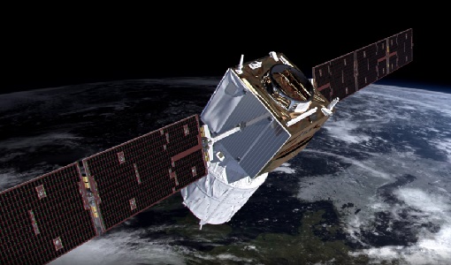
Young scientists bid farewell to ESA's wind mission
Students and early career researchers are saying an emotional goodbye to Aeolus ahead of its upcoming reentry.
News - Success Stories
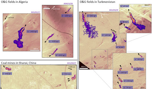
WorldView-3 satellite maps methane plumes at very high spatial resolution
Substantial advances have been made in the last years towards the detection and quantification of methane emissions from space- very high spatial resolution data from the WorldView-3 satellite can fill an important observational gap in the remote sensing of methane point emissions.
News - Success Stories

WorldView-3 helps to track offshore methane plumes from oil and gas
Scientists have used Earth observation data to reveal enormous methane plumes spilling out from an offshore oil and gas production rig in the Gulf of Mexico. This represents a significant breakthrough in the monitoring of industrial methane emissions from space.
Event - Workshop

Workshop on International Cooperation in Spaceborne Imaging Spectroscopy
The workshop aimed to recommend future international coordination permitting cooperation in the deployment, operation, and exploitation of space-based imaging spectrometers for terrestrial and coastal scientific and operational applications.
Campaign

WISE
The objective of WInd and Salinity Experiment 2001 (WISE 2001) campaign was to get more data points and better wind speed measurements.
Campaign
WindVal III
The objectives the WindVal III campaign were derived from results, experience and lessons learnt of the last airborne campaigns in 2009, 2015 and 2016.
Data - Campaigns (Open)
WindVal III
The objectives the WindVal III campaign were Early correlative observations between Aeolus and the airborne A2D and 2-µm DWL wind lidar systems
Campaign
WindVal II
The objectives for the WindVal II campaign in 2016 were derived from the results, experience and lessons learnt from these last airborne campaigns in 2009 and 2015.
Data - Campaigns (Open)

WindVal II
The objectives for the WindVal II campaign in 2016 were derived from the results, experience and lessons learnt from these last airborne campaigns in 2009 and 2015.
Campaign
WindVal I
The objectives of the WindVal 1 campaign in 2015 were derived from results, experience and lessons learnt from the previous airborne campaign in 2009.
Data - Campaigns (Open)
WindVal I
The objectives of the WindVal 1 campaign in 2015 were derived from results, experience and lessons learnt from the previous airborne campaign in 2009.
Document - Product Specifications

wind-scatterometer-processing-requirements-from-sigma-nought-triplets-to-dealiased-wind.pdf
This document defines the ground processing algorithms for the ERS-1 AMI wind mode (Scatterometer) from the sigma nought triplets to the wind speed and direction, including the wind retrieval and the ambiguity removal processing.
News - Success Stories
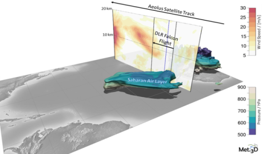
Wind measurement campaign validates Aeolus data
Aeolus VAlidation Through Airborne LidaRs in the Tropics (AVATART) was one of the two scientific campaigns carried out on Sal Island, Cape Verde during the month of September 2021.
News - Infographics
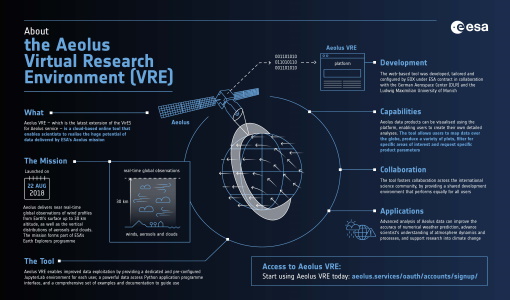
What is Aeolus VRE?
Learn more about the the Aeolus Virtual Research Environment (VRE), the latest extension to the VirES for Aeolus service, in this infographic.
News - Infographics

What are the next Earth Explorers?
Learn about the planned missions in the Earth Explorers programme - EarthCARE, Biomass, FLEX, and FORUM - which will further our understanding of Earth’s climate.
Document - General Reference

WATS - Water Vapour and Temperature in the Troposphere and Stratosphere.pdf
This report describes the WATS mission, one of the candidate Earth Explorers in the second cycle in 2001.
Campaign
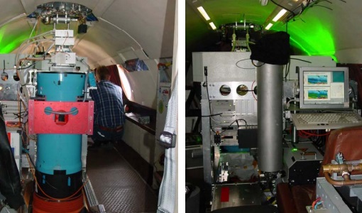
WALEX
The objective of the airborne campaign Water Vapour Lidar Experiment (WALEX) is to collect valuable data to provide representative lidar measurements of water vapour and aerosol properties in different climatic zones.
Data - Campaigns (Open)
WALEX
The objective of (WALEX) was to collect valuable data to provide representative lidar measurements of water vapour and aerosol properties in different climatic zones.
Document - Technical Note

WALES - Water Vapour Lidar Experiment in Space
This report describes the WALES mission, one of the candidate Earth Explorers in the second cycle in 2001.
Data - EO Sign In Authentication (Open)

VT GOCE Data
This collection contains the VT GOCE software and associated data set needed to run the software that is used for GOCE data visualisation.