- All Categories (24511)
- Data (7)
- News (45)
- Missions (5)
- Events (15)
- Tools (5)
- Activities (3)
- Documents (24431)
Document - Product Readme Note

ERS-1-and-2-manoeuvres-history-since-launch.pdf
The objective of this technical note is to give all information related to manoeuvres performed on ERS satellites since their launch on 17 July 1991 for ERS-1 and 21 April 1995 for ERS-2 up to the end of 1995.
Document - General Reference

ERS-1-Mission-Announcement-of-Opportunity.pdf
The ERS-1 Announcement of Opportunity for basic scientific research studies and application-oriented projects issued in 1986 resulted in approximately 250 Proposals Principal Investigators (Pl's) being accepted within the ERS-1 Science and Application Plan.
Document - General Reference
ERS-1-Ground-Segment-Acronyms-Abbreviations-and-glossary-of-terminology.pdf
This document contains the acronyms, abbreviations and glossary of terminology for the ERS-1 project, mainly in the area of the Ground Segment.
Document - General Reference
ERS-1-A-keen-eye-on-the-Earth.pdf
This document presents a brief overview of the ERS mission and the main features of the satellite and its instruments.
Document - General Reference
Aeolus-ESAs-Wind-Mission.pdf
This brochure provides information on ADM-Aeolus, ESA's future Wind Mission and Earth Explorer. The Aeolus satellite will carry one large instrument - the atmospheric laser Doppler instrument Al~ADIN, which will probe the lowermost 30 km of the atmosphere from an orbit 400 km above the Earth's surface.
Document - Product Document

Annex-E-ERS-1-ALT-WDR-Products-CCT-Format-Specifications.pdf
This product consists of the altimeter transcribed raw data with associated immediately available calibrations, corrections, geolocation and characterisation. This product is routinely generated on receipt of altimeter data at UK-PAF.
Document - Product Document
ANNEX-A-ERS-1-ALT-RAW-Products-CCT-Format-Specification.pdf
Historical Document.This document deals with the product specification of the Altimeter Raw Data Product which provides the user with annotated, uncorrected altimeter measures, sensor parameters and sensor characteristics.
Document - Product Document
Annex-D-ERS-1-ALT-OPR-Product-CCT-Format.pdf
This product aims at providing the users with geophysically corrected altimeter measures over ocean, including all the engineering corrections and all the geophysical corrections due to the troposphere, the ionosphere and the electromagnetic bias. In addition, the surface altitude over the ellipsoid is calculated, correcting for the surface elevation due to tides and geoid.
Document - Product Document
ANNEX-B-ERS-1-ALT-FDC-Products-CCT-Format-Specifications.pdf
This document deals with the product specification of the Altimeter Fast Delivery Copy. Valid for data processed up until July '95 when there was a switch from CEOS to CCSDS.
Event - Workshop

Applications of the ERS Along Track Scanning Radiometer Workshop 1999
The workshop on ERS mission's Along Track Scanning Radiometer (ATSR) instrument gathered researchers and specialists working on different applications of the mission.
Event - Workshop
CryoSat 2005 Workshop
The workshop provided new and familiar users of the mission with a detailed understanding of the mission status and projected performance at launch, and provided the first presentation to users of the processing algorithms.
Event - Conference

15 Years of Progress in Radar Altimetry Symposium
A Symposium on "15 Years of Progress in Radar Altimetry" and the annual meeting of the Ocean Surface Topography Science Team, the International Doris Service Workshop and the ARGO Workshop.
Event - Training

Advanced Training Course on Ocean Remote Sensing 2006
The objective of the course was to provide first-hand information on a broad range of ocean research topics including key principles of SAR, Radar Altimetry, Ocean Colour and Sea Surface Temperature measurements, processing algorithms, data products and their use in oceanographic applications.
Event - Workshop
GEWEX / ESA DUE GlobVapour Quality Assessment of Water Vapour Data Sets Workshop
The workshop brought together the producers and users of water vapour data sets to define a useful water vapour data set for GEWEX.
Event - Training
3rd Advanced Training Course on Land Remote Sensing 2011
This 2011 advanced ESA training course focused on land remote sensing theory and applications.
Event - Training
Advanced Training Course in Land Remote Sensing 2012
The 2012 advanced training course focused on land remote sensing theory and applications.
Mission - Heritage Missions
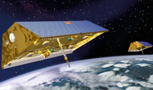
GRACE
GRACE stands for the Gravity Recovery and Climate Experiment and was a part of the international Earth Observing System (EOS) series of satellites.
News - General News

Satellite Radar Altimetry: past and future
Satellite radar altimetry measurements yield a wealth of information that can be used for a wide range of applications.
News - Success Stories

ESA's Earth Explorers surpassing expectations
In this video, learn how each Earth Explorer mission is contributing to Earth science, and changing the way we look at our beloved planet.