- All Categories (23297)
- Data (2)
- News (62)
- Missions (1)
- Events (4)
- Tools (4)
- Campaigns (4)
- Documents (23220)
Document - Proceedings

EO-Summer-School-3-Satellite-radar-21st-century-glaciology.pdf
This presentation from ESA's EO Summer School 3 describes Satellite radar – 21st century glaciology
Document - Proceedings
EO-Summer-School-3-Satellite-radar-21st-century-glaciology.pdf
This presentation from ESA's EO Summer School 3 describes Satellite radar – 21st century glaciology
Event - Workshop

CryoSat 2005 Workshop
The workshop provided new and familiar users of the mission with a detailed understanding of the mission status and projected performance at launch, and provided the first presentation to users of the processing algorithms.
Event - Training

Advanced Training Course in Land Remote Sensing 2012
The 2012 advanced training course focused on land remote sensing theory and applications.
News - Events and Proceedings

Seventh CryoSat Quality Working Group meeting - final report
The 7th CryoSat Quality Working Group (QWG) meeting Summary and Recommendation Report are available to download.
Event - Conference

CryoSat 10th Anniversary Science Conference
The conference focussed on the latest scientific results from the mission, it was also a celebration of the remarkable contribution CryoSat has made to our understanding of the cryosphere.
Mission - Earth Explorers

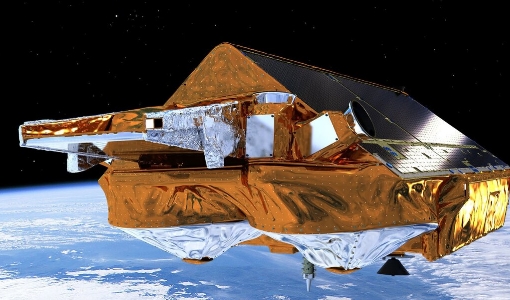
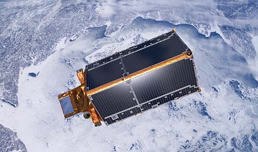
CryoSat
CryoSat determines variations in the thickness of continental ice sheets and marine ice cover. Europe's first ice mission is an advanced radar altimeter specifically designed to monitor the most dynamic sections of Earth's cryosphere.
News - Data Release news

Updated CryoSat magnetometer data now available
An improved version of the CryoSat magnetic field data (version 0102) is now available in the "#CryoSat-2" folder of the ESA FTP server.
Data - Open access (Open)
CryoSat products
CryoSat's primary payload is the SAR/Interferometric Radar Altimeter (SIRAL) which has extended capabilities to meet the measurement requirements for ice-sheet elevation and sea-ice freeboard. CryoSat also carries three star trackers for measuring the orientation of the baseline. In addition, a radio receiver called Doppler Orbit and Radio Positioning Integration by Satellite (DORIS) and a small laser retroreflector ensures that CryoSat's position will be accurately tracked. More detailed information on CryoSat instruments is available on the CryoSat mission page. The following CryoSat datasets are available and distributed to users: Level 1B and L2 Ice products: NRT, LRM, SAR and SARIn Consolidated Level 2 (GDR): (LRM+SAR+SARIN) consolidated ice products over an orbit Intermediate Level 2 Ice products: LRM, SAR and SARIn L1b and L2 Ocean Products: NOP, GOP and IOP Cryo-TEMPO Land Ice Cryo-TEMPO Sea Ice Cryo-TEMPO Coastal Ocean Cryo-TEMPO Polar Ocean Cryo-TEMPO Inland Waters Cryo-TEMPO EOLIS Point Products Cryo-TEMPO EOLIS Gridded Products CryoSat Quaternions Product. Detailed information concerning each of the above datasets is available in the CryoSat Products Overview. CryoSat Ice and Ocean products CryoSat Level 1B altimetric products contain time and geo-location information as well as SIRAL measurements in engineering units. Calibration corrections are included and have been applied to the window delay computations. In Offline products, geophysical corrections are computed from Analysis Auxiliary Data Files (ADFs), whereas in FDM products corrections are computed for Forecast ADFs. All corrections are included in the data products and therefore the range can be calculated by taking into account the surface type. The Offline Level 2 LRM, SAR and SARIn ice altimetric products are generated 30 days after data acquisition and are principally dedicated to glaciologists working on sea-ice and land-ice areas. The Level 2 FDM products are near-real time ocean products, generated 2-3 hours after data acquisition, and fulfill the needs of some ocean operational services. Level 2 products contain the time of measurement, the geo-location and the height of the surface. IOP and GOP are outputs of the CryoSat Ocean Processor. These products are dedicated to the study of ocean surfaces, and provided specifically for the needs of the oceanographic community. IOP are generated 2-3 days after data sensing acquisition and use the DORIS Preliminary Orbit. GOP are typically generated 30 days after data sensing acquisition and use the DORIS Precise Orbit. Geophysical corrections are computed from the Analysis ADFs, however following the oceanographic convention the corrections are available but not directly applied to the range (as for FDM). CryoSat Ice and Ocean products can be accessed through ftp://science-pds.cryosat.esa.int/ via an FTP client and HTTPS under the folders named “SIR_” followed by the data product type and the processing level (e.g., SIR_SAR_L2 for Level 2 SAR data). Additionally, data can be downloaded from all the other services listed in the How to Access Data section. Cryo-TEMPO Products The CryoSat ThEMatic PrOducts (Cryo-TEMPO) projects aim to deliver a new paradigm of simplified, harmonized, and agile CryoSat-2 products, that are easily accessible to new communities of non-altimeter experts and end users. The Cryo-TEMPO datasets include dedicated products over five thematic areas, covering Sea Ice, Land Ice, Polar Ocean, Coastal Ocean and Inland Water. The standard Cryo-TEMPO products include fully-traceable uncertainties and use rapidly evolving, state-of-the-art processing dedicated to each thematic area. Throughout the project, the products will be constantly evolved, and validated by a group of Thematic Users, thus ensuring optimal relevance and impact for the intended target communities. More information on the Cryo-TEMPO products can be found in the Product Handbook and on the Project Website. The products can be accessed through ftp://science-pds.cryosat.esa.int/ via an FTP client and HTTPS under the folders named “TEMPO_POCA_(SI/LI/PO/CO/IW)", where the last two letters are the initials of the thematic area (e.g., SI stands for Sea Ice). Cryo-TEMPO EOLIS The CryoTEMPO-EOLIS swath product exploits CryoSat's SARIn mode and the novel Swath processing technique to deliver increased spatial and temporal coverage of time-dependent elevation over land ice, a critical metric for tracking ice mass trends in support to a wide variety of end-users. The dataset consists of systematic reprocessing of the entire CryoSat archive to generate new L2-Swath products, increasing data sampling by 1 to 2 orders of magnitude compared with the operational L2 ESA product. In addition, the EOLIS dataset is joined with the ESA L2 Point-Of-Closest-Approach to generate monthly DEM (Digital Elevation Model) products. This dataset will further the ability of the community to analyse and understand trends across the Greenland Ice Sheet margin, Antarctica and several mountain glaciers and ice caps around the world. More information on the Cryo-TEMPO products can be found on the Project Website and the products can be accessed through ftp://science-pds.cryosat.esa.int/ via an FTP client and HTTPS under the folders named “TEMPO_SWATH_(POINT/GRID)”, where the last word is used to choose between the available “Point” and “Gridded” datasets. Additionally, Cryo-TEMPO EOLIS products can be visualised and downloaded from the CS2EO Platform. CryoSat Quaternions Product This product contains the attitude quaternions for the CryoSat-2 mission. It is obtained starting from the corrected mispointing angles measured by the platform star trackers. More information on the product can be found in the Algorithm Description and Product Format Specification documents. The quaternions product can be accessed from the CryoSat CalVal FTPS server via an FTPS client, and are located in the “AUX_PROQUA” folder. Users wishing to access the quaternions products should request a personal account to be created by emailing the CryoSat Mission Geophysicist, Dr. Alessandro Di Bella (alessandro.di.bella@ext.esa.int).
News - Success Stories
CryoSat still cool at 10
Today marks 10 years since a Dnepr rocket blasted off from an underground silo in the remote desert steppe of Kazakhstan
News - Data Release news
2014 CryoSat Ice Baseline D reprocessed data available
Reprocessed CryoSat Ice Baseline D data for all 2014 has been published on the Science Server and is available for download.
News - Data Release news

2011 CryoSat Ice Baseline D reprocessed data available
We are pleased to inform the CryoSat scientific community that the reprocessed CryoSat Ice Baseline D data for all of 2011 has been published on the Science Server and is available for download.
News - Data Release news

2012 CryoSat Ice Baseline D reprocessed data now available
We're pleased to inform the CryoSat scientific community that the reprocessed CryoSat Ice Baseline D data for all of 2012 has been published on the Science Server and is now available for download.
News - Data Release news

Systematic swath elevation and monthly DEMs over the Greenland Ice Sheet margin from CryoSat
The CryoTEMPO-EOLIS (Elevation Over Land Ice from Swath), the first of the CryoTEMPO products, is now available.
Document - Product Handbook

CryoTEMPO-Thematic-Product-Handbook.pdf
The CryoTEMPO Product Handbook describes the operational products, a point cloud product containing the elevations derived using a swath processing algorithm and a gridded product with elevations at regularly spaced points on a grid.
News - Data Release news

New CryoSat BUFR products for the meteorological community
From 11 May new CryoSAT NOP data will be disseminated by ESA to the Italian MetOffice.
News - Data Release news
2015 CryoSat Ice Baseline D reprocessed data now available
The reprocessed CryoSat Ice Baseline D data for all of 2015 has now been published on the Science Server.
News - Data Release news

2016 CryoSat Ice Baseline D reprocessed data now available
The reprocessed CryoSat Ice Baseline D data for 2016 has now been published on the Science Server.
News - Data Release news
2017 CryoSat Ice Baseline D reprocessed data available
The reprocessed CryoSat Ice Baseline D data for all of 2017 is now available for download.
News - Data Release news

Complete CryoSat Ice Baseline D reprocessed dataset now available
We're pleased to inform the CryoSat scientific community that the full reprocessed CryoSat Ice Baseline D data are now available on the Science Server for download