- All Categories (40)
- News (1)
- Missions (2)
- Events (1)
- Tools (5)
- Activities (4)
- Documents (27)
Document - Algorithms Theoretical Baseline Document

MERIS-ATBD-2-24.pdf
Vicarious adjustment of the MERIS Ocean Colour Radiometry.
Document - Algorithms Theoretical Baseline Document
MERIS-ATBD-2-9.pdf
Pigment Index Retrieval in Case 1 Waters.
Document - Product Document

ENVISAT_AATSR_consolidated_Level-0_dataset_completeness.pdf
This document reports on the completeness of the AATSR consolidated Level 0 dataset. The analysis was performed by IDEAS and includes recommendations for building a clean and complete consolidated Level 0 dataset for reprocessing campaigns
Document - Product Cal/Val Plan/Report

Validation Report following the 3rd MERIS data reprocessing
This document prepared by the MERIS Quality Working Group (QWG) corresponds to the Validation Report following the 3rd MERIS data reprocessing. It aims at qualifying and quantifying the accuracy of the MERIS L2 products generated with the version 8.0 of MERIS Ground Segment prototype (MEGS), delivered to the whole community through the ODESA software (http://earth.eo.esa.int/odesa/). It is equivalent to version 6.0 of the Instrument Processing Facilities (IPF) at ESRIN.
Document - Product Cal/Val Plan/Report
ERS-2-OPR-Product-Validation-Report.pdf
This report focuses on the inspection of the OPR products and the associated user documentation.
Document - Technical Note

Draft-specification-of-ATSR-SADIST-2-products.pdf
This document is a draft specification of the scientific products from RAL's SADIST-2 ATSR data-processing software. Since SADIST-2 is being developed such that it can process data from both ATSR-1 and ATSR-2 instruments, the products described here have been designed to be sufficiently flexible and modular that they are equally valid for either instrument.
Document - Technical Note
Investigation-into-ATSR-1-and-ATSR-2-data-availability.pdf
Envisat-style products for ATSR-1 and ATSR-2 data.
Document - Technical Note
MERIS-Level-2-Detailed-Processing-Model.pdf
This document is the Detailed Processing Model document for the MERIS data processing. It covers the MERIS Level 2 processing.
Document - Technical Note
MERIS-Level-1-Detailed-Processing-Model-Parameters-Data-List.pdf
This document is the Detailed Processing Model and Parameters Data List document for the MERIS data processing.
Document - Technical Note
MERIS-Detailed-Instrument-Description.pdf
This document provides information about the Envisat platform, each part of the MERIS instrument and internal data flow. A more detailed description is provided in the MERIS Product Handbook.
Document - User Guide

FM94-BUFR-Encoding-Software-for-ERS Data-Software-User-Manual.pdf
This user manual is applicable to Version 5 of the World Meteorological Organization (WMO) FM94 BUFR Decoding Software for ERS data. It describes: The installation of the software, the post-installation testing of the software, the user interfaces to the BUFR encoder, the completion status and error codes that can be expected, and how corrupt products are handled.
Document - Software Verification Plan/Report

Decoding-Software-for-ERS-Data-for-FM94-BUFR.pdf
This document describes how to decode ERS Low Bit Rate (LBR) Fast Delivery (FD) products from the World Meteorological Organisation (WMO) standard FM94 BUFR format required for transmission to users via the WMO Global Telecommunications System (GTS).
Event - Workshop

Applications of the ERS Along Track Scanning Radiometer Workshop 1999
The workshop on ERS mission's Along Track Scanning Radiometer (ATSR) instrument gathered researchers and specialists working on different applications of the mission.
Tools - Analysis
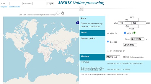
Optical Data processor of the European Space Agency
ODESA system provides a complete Level 2 processing environment for the MERIS instrument and future Sentinel-3 optical sensors.
Tools - Processing
AMORGOS
The AMORGOS tool generates accurate geo-location GOS E information (longitude, latitude, altitude) for each MERIS pixel.
Tools - Processing

SciaL1C Command-line Tool
The SCIAMACHY Calibration and Extraction Tool (SciaL1c) is an application to process SCIAMACHY Level 1b products. It allows you to select specific calibrations to apply to Level 1b data.