- All Categories (344)
- Data (10)
- News (21)
- Missions (2)
- Events (18)
- Tools (6)
- Activities (3)
- Documents (284)
News - Events and Proceedings
Very High Resolution data to take centre stage
In the last few years, European New Space providers have helped strengthen the offering of very high resolution remote sensing data products—a designated workshop this November aims to focus on the latest developments in this arena.
Document - Product Cal/Val Plan/Report
Validation Report following the 3rd MERIS data reprocessing
This document prepared by the MERIS Quality Working Group (QWG) corresponds to the Validation Report following the 3rd MERIS data reprocessing. It aims at qualifying and quantifying the accuracy of the MERIS L2 products generated with the version 8.0 of MERIS Ground Segment prototype (MEGS), delivered to the whole community through the ODESA software (http://earth.eo.esa.int/odesa/). It is equivalent to version 6.0 of the Instrument Processing Facilities (IPF) at ESRIN.
Document - Technical Note
UWA Processing Algorithm Specification
This technical note specifies version 2 of the algorithm to derive SAR wave spectrum products from ERS AMI wave mode data.
Document - General Reference
Two Years of ERS-1 Data Exploitation
This bulletin reports on the first two years of the ERS-1 satellite.
Document - Technical Note
Tracking a Tropical Cyclone with ERS-Scatt report
Tracking a Tropical Cyclone with ERS-Scatt: a CMOD4 Model Review
Document - Publication - Paper
Tracking a Tropical Cyclone with ERS-Scatt paper
Tracking a Tropical Cyclone with ERS-Scatt: a CMOD Model Review
Document - Proceedings
Thematic Applications of SAR Data
This document presents the proceedings from a workshop held at ESA/ESRIN in Frascati, Italy, from 09 to 11 September 1985 regarding the ERS mission and the SAR instrument.
Document - Product Cal/Val Plan/Report
The-Calibration-of-the-ERS-1-Radar-Altimeter.pdf
This report describes the calibration of ERS-1's Radar Altimeter during the commissioning phase, which used Venice as a basis for calibration.
Document - Technical Note
The SeaSat-A Synthetic Aperture Radar System
The SeaSat-A synthetic aperture radar imaging radar system (SAR) was the first imaging radar system used as a scientific instrument from Earth orbit. The system generated continuous radar imagery with a 100 km swath at a resolution of 25 m from an 800 km altitude orbit. The imagery is a pictorial representation of the radar backscatter of the Earth's surface in a map-like representation.
News - Infographics
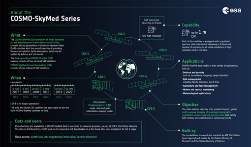
The COSMO-SkyMed series - Two generations of SAR satellites
Learn about the COSMO-SkyMed (Constellation of small Satellites for the Mediterranean basin Observation) series in our latest infographic.
Data - Sample Data (Open)
TerraSAR-X Sample Data
Download free TerraSAR-X sample datasets to preview products available for this mission.
Document - Technical Note
Technical-Note-on-Data-Flows-and-Volumes-between-ISS-and-Other-Entities-of-the-ERS-1-Ground-Segment.pdf
This document lists all the messages exchanged between the Interface Subset (ISS) and the other entities of the ERS-1 Ground Segment.
Document - General Reference
spaceborne-radar-applications-in-geology-an-introduction.pdf
This document is intended for geologists who are interested in broadening their knowledge of interpretation of imaging radar data. It introduces imaging radar as it may be used by technicians and image interpreters. Interferometric SAR is briefly treated, with some basic and practical hints. An illustrated application study on land subsidence is included.
News - Thematic area articles
Space data support Earth’s ecosystems
ESA’s Earth observation (EO) missions are making a critical contribution to monitoring transformations in our planet’s ecosystems, helping track changes in the vegetation, soil, and ocean that affect these systems.
Document - General Reference
Shrimp farm inventory and monitoring
This series produced by the Environment and Natural Resources Service of FAQ aims to present the possibilities of remote sensing techniques for natural resource management and planning.
Activity - Quality
SEOM CAWA
The Advanced Clouds, Aerosols and WAter vapour products for Sentinel-3/OLCI project aims to develop and improve the advanced atmospheric retrieval algorithms developed for MERIS and OLCI instruments.
Data - EO Sign In Authentication (Open)
SeaSat ESA archive
This collection gives access to the complete SEASAT dataset acquired by ESA and mainly covers Europe. The dataset comprises some of the first ever SAR data recorded for scientific purposes, reprocessed with the most recent processor. The Level-1 products are available as: SAR Precision Image [SEA_PRI_1P] SAR Single Look Complex Image [SEA_SLC_1P] SAR Ellipsoid Geocoded Precision Image [SEA_GEC_1P] Spatial coverage: Check the spatial coverage of the collection on a map available on the Third Party Missions Dissemination Service.

