- All Categories (10)
- Data (4)
- News (3)
- Missions (2)
- Events (1)
News - Success Stories
Commercial and international data for fire monitoring
As climate change sparks a surge in the frequency and intensity of wildfires, satellite data disseminated through ESA’s Third Party Missions (TPM) programme are helping scientists to track and investigate these potentially damaging natural events.
News - Thematic area articles
Global understanding of Earth's land surfaces greatly boosted by satellite data
ESA perform land surface monitoring with a range of instruments onboard satellites acquiring optical and radar data. Collections of data from these missions are freely available for research purposes.
News - Data Release news
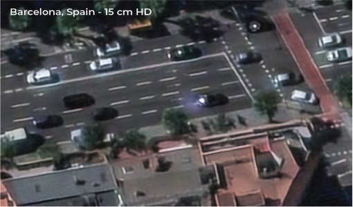
15 cm HD and 30 cm HD products added to EUSI ESA archive collections
Two new products, 15 cm HD and 30 cm HD, have been added to the collections from GeoEye-1, QuickBird-2, and WorldView (1 – 4).
Data - Fast Registration with approval (Restrained)
WorldView ESA archive
The WorldView ESA archive is composed of products acquired by WorldView-1, -2, -3 and -4 satellites and requested by ESA supported projects over their areas of interest around the world Panchromatic, 4-Bands, 8-Bands and SWIR products are part of the offer, with the resolution at Nadir depicted in the table. Band Combination Mission GSD Resolution at Nadir GSD Resolution (20° off nadir) Panchromatic WV-1 50 cm 55 cm WV-2 46 cm 52 cm WV-3 31 cm 34 cm WV-4 31 cm 34 cm 4-Bands WV-2 1.84 m 2.4 m WV-3 1.24 m 1.38 m WV-4 1.24 m 1.38 m 8-Bands WV-2 1.84 m 2.4 m WV-3 1.24 m 1.38 m SWIR WV-3 3.70 m 4.10 m The 4-Bands includes various options such as Multispectral (separate channel for Blue, Green, Red, NIR1), Pan-sharpened (Blue, Green, Red, NIR1), Bundle (separate bands for PAN, Blue, Green, Red, NIR1), Natural Colour (pan-sharpened Blue, Green, Red), Coloured Infrared (pan-sharpened Green, Red, NIR). The 8-Bands being an option from Multispectral (COASTAL, Blue, Green, Yellow, Red, Red EDGE, NIR1, NIR2) and Bundle (PAN, COASTAL, Blue, Green, Yellow, Red, Red EDGE, NIR1, NIR2). The processing levels are: Standard (2A): normalised for topographic relief View Ready Standard: ready for orthorectification (RPB files embedded) View Ready Stereo: collected in-track for stereo viewing and manipulation (not available for SWIR) Map Scale (Ortho) 1:12,000 Orthorectified: additional processing unnecessary Spatial coverage: Check the spatial coverage of the collection on a map available on the Third Party Missions Dissemination Service. The following table summarises the offered product types EO-SIP Product Type Band Combination Processing Level Missions WV6_PAN_2A Panchromatic (PAN) Standard/View Ready Standard WorldView-1 and 4 WV6_PAN_OR Panchromatic (PAN) View Ready Stereo WorldView-1 and 4 WV6_PAN_MP Panchromatic (PAN) Map Scale Ortho WorldView-1 and 4 WV1_PAN__2A Panchromatic (PAN) Standard/View Ready Standard WorldView-2 and 3 WV1_PAN__OR Panchromatic (PAN) View Ready Stereo WorldView-2 and 3 WV1_PAN__MP Panchromatic (PAN) Map Scale Ortho WorldView-2 and 3 WV1_4B__2A 4-Band (4B) Standard/View Ready Standard WorldView-2, 3 and 4 WV1_4B__OR 4-Band (4B) View Ready Stereo WorldView-2, 3 and 4 WV1_4B__MP 4-Band (4B) Map Scale Ortho WorldView-2, 3 and 4 WV1_8B_2A 8-Band (8B) Standard/View Ready Standard WorldView-2 and 3 WV1_8B_OR 8-Band (8B) View Ready Stereo WorldView-2 and 3 WV1_8B_MP 8-Band (8B) Map Scale Ortho WorldView-2 and 3 WV1_S8B__2A SWIR Standard/View Ready Standard WorldView-3 WV1_S8B__MP SWIR Map Scale Ortho WorldView-3 As per ESA policy, very high-resolution imagery of conflict areas cannot be provided.
Data - Fast Registration with approval (Restrained)
WorldView-1 full archive and tasking
WorldView-1 high resolution optical products are available as part of the Maxar Standard Satellite Imagery products from the QuickBird, WorldView-1/-2/-3/-4, and GeoEye-1 satellites. All details about the data provision, data access conditions and quota assignment procedure are described into the Terms of Applicability available in Resources section. In particular, WorldView-1 offers archive and tasking panchromatic products up to 0.50 m GSD resolution. Band Combination Data Processing Level Resolution Panchromatic Standard(2A)/View Ready STANDARD (OR2A) 50 cm, 30 cm HD View Ready Stereo 50 cm Map-Ready (Ortho) 1:12.000 Orthorectified 50 cm, 30 cm HD Native 50 cm resolution products are processed with MAXAR HD Technology to generate the 30 cm HD products: the initial special resolution (GSD) is unchanged but the HD technique increases the number of pixels and improves the visual clarity achieving aesthetically refined imagery with precise edges and well reconstructed details. As per ESA policy, very high-resolution imagery of conflict areas cannot be provided.
Data - Fast Registration with approval (Restrained)
TerraSAR-X ESA archive
The TerraSAR-X ESA archive collection consists of TerraSAR-X and TanDEM-X products requested by ESA supported projects over their areas of interest around the world. The dataset regularly grows as ESA collects new products over the years. TerraSAR-X/TanDEM-X Image Products can be acquired in 6 image modes with flexible resolutions (from 0.25m to 40m) and scene sizes. Thanks to different polarimetric combinations and processing levels the delivered imagery can be tailored specifically to meet the requirements of the application. The following list delineates the characteristics of the SAR imaging modes that are disseminated under ESA Third Party Missions (TPM). StripMap (SM): Resolution 3 m, Scene size 30x50 km2 (up to 30x1650 km2) SpotLight (SL): Resolution 2 m, Scene size 10x10 km2 Staring SpotLight (ST): Resolution 0.25m, Scene size 4x3.7 km2 High Resolution SpotLight (HS): Resolution 1 m, Scene size 10x5 km2 ScanSAR (SC): Resolution 18 m, Scene size 100x150 km2 (up to 100x1650 km2) Wide ScanSAR (WS): Resolution 40 m, Scene size 270x200 km2 (up to 270x1500 km2) The following list briefly delineates the available processing levels for the TerraSAR-X dataset: SSC (Single Look Slant Range Complex) in DLR-defined COSAR binary format MGD (Multi Look Ground Range Detected) in GeoTiff format • GEC (Geocoded Ellipsoid Corrected) in GeoTiff format EEC (Enhanced Ellipsoid Corrected in GeoTiff format Spatial coverage: Check the spatial coverage of the collection on a map available on the Third Party Missions Dissemination Service. As per ESA policy, very high-resolution data over conflict areas cannot be provided.
Data - Project Proposal (Restrained)
TerraSAR-X/TanDEM-X full archive and tasking
TerraSAR-X/TanDEM-X full archive and new tasking products can be acquired in six image modes with flexible resolutions (from 0.25 m to 40 m) and scene sizes and are provided in different packages: Staring SpotLight (basic, Interferometric pack, and Maritime pack) High Resolution SpotLight (basic, Interferometric pack, and Maritime pack) SpotLight (basic, Interferometric pack, and Maritime pack) StripMap (basic, Interferometric pack, and Maritime pack) ScanSAR (basic and Maritime pack) Wide ScanSAR (basic and Maritime pack) Product Overview Products SAR-ST SAR-HS SAR-SL SAR-SM SAR-SC SAR-WS Instrument mode Staring Spotlight High Resolution SpotLight SpotLight StripMap ScanSAR Wide ScanSAR Available resolutions (up to) 0.25 m 1 m 2 m 3 m 18 m 40 m Scene size 4x3.7 km2 10x5 km2 10x10 km2 30x50 km2 (up to 30x1650) 100x150 km2 (up to 100x1650) 270x200 km2 (up to 270x1500) Available processing levels SSC (Single Look Slant Range Complex): azimuth - slant range (time domain) MGD (Multi Look Ground Range Detected): azimuth - ground range (without terrain correction) GEC (Geocoded Ellipsoid Corrected): map geometry with ellipsoidal corrections only (no terrain correction performed) EEC (Enhanced Ellipsoid Corrected): map geometry with terrain correction, using a DEM Format SSC: DLR-defined COSAR binary MGD: GeoTiff GEC: GeoTiff EEC: GeoTiff Spatial coverage Worldwide Interferometry package InSAR-ST, InSAR-HS, InSAR-SL, InSAR-SM Only SSC At least five ordered scenes within six months from first order N/A N/A Maritime Monitoring package MmSAR-ST, MmSAR-HS, MmSAR-SL, MmSAR-SM, MmSAR-SC, MmSAR-WS Only SSC, MGD, GEC At least 75% of the scene area is water More than five ordered scenes in three months The following WorldDEM products can be requested: Products Description WorldDEMcore WorldDEMcore is output of interferometric processing of StripMap data pairs without any post-processing WorldDEMTM WorldDEMTM is produced based on WorldDEMcore, representing the surface of the Earth (including buildings, infrastructure and vegetation). Hydrological consistency is ensured WorldDEM DTM In additional editing steps, WorldDEMTMis transformed into a Digital Terrain Model (DTM) representing bare Earth elevation WorldDEM Bundle Includes WorldDEMTM, WorldDEM DTM, and Quality Layers The main specifications of the WorldDEM products are: Horizontal Coordinate Reference System: World Geodetic System 1984 (WGS84-G1150) Vertical Coordinate Reference System: Earth Gravitational Model 2008 (EGM2008) Absolute Horizontal Accuracy: <6 m Vertical Accuracy: 2 m Relative, 4 m Absolute Quality Layers (including water body mask) can be requested as an option with the WorldDEM and WorldDEM DTM Auxiliary Layers are delivered together with the WorldDEMcore product As per ESA policy, very high-resolution data over conflict areas cannot be provided.
Mission - Third Party Missions
WorldView-1
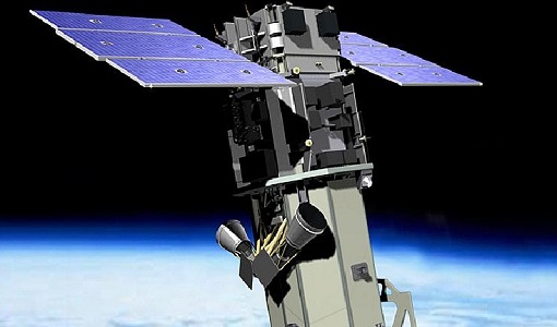
WorldView-1 helped meet the growing commercial demand for multi-spectral geospatial imagery.
Mission - Third Party Missions
WorldView Series
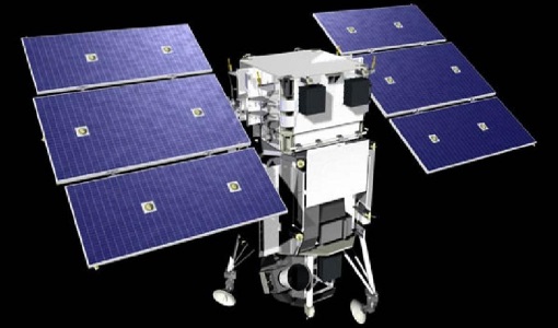
The WorldView constellation are environment-monitoring satellites that have been supplying imagery since 2007.
Event - Meeting
VH-RODA and CEOS SAR workshop
The workshop provided an open forum for the presentation and discussion of current status and future developments related to the calibration and validation of space borne very high-resolution SAR and optical sensors and data products.


