- All Categories (25)
- Data (14)
- News (4)
- Missions (1)
- Events (6)
Data - EO Sign In Authentication (Open)
VT GOCE Data
This collection contains the VT GOCE software and associated data set needed to run the software that is used for GOCE data visualisation.
News - Events and Proceedings
Scientists to showcase value of Earth observation data at EGU
Remote sensing scientists are getting ready to present innovative and exciting applications of satellite data at the European Geosciences Union general assembly which will take place from 24 to 28 April in Vienna, Austria.
Mission - Heritage Missions
NOAA POES
NOAA's AVHRR sensor is carried on the POES mission, a constellation of polar orbiting weather satellites.
News - Data Release news
New product baseline for the GOCE Gravity solution Grids available
A second product baseline of the GOCE Gridded Gravity gradients and anomalies at Ground Level and at Satellite Height has been generated and released to users.
Event - Conference
Living Planet Symposium 2019
ESA's Living Planet Symposia are amongst the biggest Earth observation conferences in the world. Scientists present their latest findings on Earth's environment and climate.
News - Success Stories
Gravity Field Models from Swarm data
In addition to its geomagnetic objectives, GPS receivers onboard Swarm can and have already been exploited to measure temporal variations in Earth's global gravity field.
News - Infographics
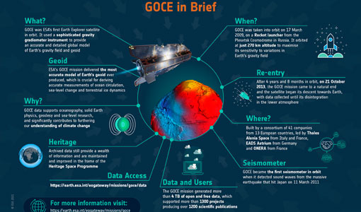
GOCE – An overview of ESA’s gravity satellite mission
Learn more about ESA's first Earth Explorer - the Gravity field and Ocean Circulation Explorer (GOCE) mission - in our latest infographic.
Data - EO Sign In Authentication (Open)
GOCE Thermosphere Data
Thermospheric density and crosswind data products derived from GOCE data. Latest baseline _0200. The GOCE+ Air Density and Wind Retrieval using GOCE Data project produced a dataset of thermospheric density and crosswind data products which were derived from ion thruster activation data from GOCE telemetry. The data was combined with the mission's accelerometer and star camera data products. The products provide data continuty and extend the accelerometer-derived thermosphere density data sets from the CHAMP and GRACE missions. The resulting density and wind observations are made available in the form of time series and grids. These data can be applied in investigations of solar-terrestrial physics, as well as for the improvement and validation of models used in space operations. Funded by ESA through the Support To Science Element (STSE) of ESA's Earth Observation Envelope Programme, supporting the science applications of ESA's Living Planet programme, the project was a partnership between TU Delft, CNES and Hypersonic Technology Göttingen. Dataset history Date Change Reason 18/04/2019 - Time series data v2.0, covering the whole mission - Updated data set user manual - New satellite geometry and aerodynamic model - New vertical wind field - New data for the deorbit phase, (GPS+ACC and GPS-only versions) Updated satellite models and additional data 14/07/2016 - Time series data v1.5, covering the whole mission - Updated data set user manual Removal of noisy data 31/07/2014 - Time series data v1.4, covering the whole mission - Gridded data, now including error estimates - Updated data set user manual; Updated validation report; Updated ATBD Full GOCE dataset available 28/09/2013 Version 1.3 density/winds timeseries and gridded data released. User manual updated to v1.3 Bug fix and other changes 04/09/2013 Version 1.2 density/winds timeseries and gridded data released, with user manual First public data release of thermospheric density/winds data
Data - EO Sign In Authentication (Open)
GOCE Telemetry
This collection contains all GOCE platform and instruments telemetry. For details see the Packets Description file.
Data - EO Sign In Authentication (Open)
GOCE TEC and ROTI
GOCE total electron content (TEC) and rate of TEC index (ROTI) data.
Data - EO Sign In Authentication (Open)
GOCE Level 2
This collection contains GOCE level 2 data: Gravity Gradients in the gradiometer reference frame (EGG_NOM_2), in the terrestrial reference frame (EGG_TRF_2), GPS receiver derived precise science orbits (SST_PSO_2) and the non-tidal time variable gravity field potential with respect to a mean value in terms of a spherical harmonic series determined from atmospheric and oceanic mass variations as well as from a GRACE monthly gravity field time series (SST_AUX_2). EGG_NOM_2_: latest baseline: _0203 EGG_TRF_2_: latest baseline _0101 SST_AUX_2_: latest baseline _0001 SST_PSO_2_: latest baseline _0201.
Data - EO Sign In Authentication (Open)
GOCE Level 1
This collection contains the GOCE L1b data of the gradiometer, the star trackers, the GPS receiver, the magnetometers, magnetotorquers and the DFACS data of each accelerometer of the gradiometer. EGG_NOM_1b: latest baseline _0202 SST_NOM_1b: latest baseline _000x (always take the highest number available) ACC_DFx_1b: latest baseline _0001 (x=1:6) MGM_GOx_1b: latest baseline _0001 (x=1:3) MTR_GOC_1b: latest baseline _0001 SST_RIN_1b: latest baseline _000x (always take the highest number available) STR_VC2_1b: latest baseline _000x (always take the highest number available) STR_VC3_1b: latest baseline _000x (always take the highest number available).
Data - EO Sign In Authentication (Open)
GOCE Global Gravity Field Models and Grids
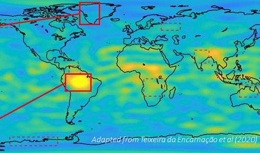
This collection contains gravity gradient and gravity anomalies grids at ground level and at satellite height. In addition it contains the GOCE gravity field models (EGM_GOC_2, EGM_GCF_2) and their covariance matrices (EGM_GVC_2): GOCE Gravity solution GRIDS Gridded Gravity gradients and anomalies at ground level: GO_CONS_GRC_SPW_2__20091101T000000_20111231T235959_0001.TGZ GO_CONS_GRC_SPW_2__20091101T055147_20120731T222822_0001.TGZ GO_CONS_GRC_SPW_2__20091101T055226_20131020T033415_0002.TGZ GO_CONS_GRC_SPW_2__20091009T000000_20131021T000000_0201.TGZ. Latest baseline is: GO_CONS_GRC_SPW_2__20091009T000000_20131021T000000_0201.TGZ. Gridded Gravity gradients and anomalies at satellite height: GO_CONS_GRD_SPW_2__20091101T055147_20100630T180254_0001.TGZ GO_CONS_GRD_SPW_2__20091101T055147_20120731T222822_0001.TGZ GO_CONS_GRD_SPW_2__20091101T055226_20131020T033415_0002.TGZ GO_CONS_GRD_SPW_2__20091009T000000_20131021T000000_0201.TGZ. Latest baseline is: GO_CONS_GRD_SPW_2__20091009T000000_20131021T000000_0201.TGZ. As output from the ESA-funded GOCE+ GeoExplore project, GOCE gravity gradients were combined with heterogeneous other satellite gravity information to derive a combined set of gravity gradients complementing (near)-surface data sets spanning all together scales from global down to 5 km. The data is useful for various geophysical applications and demonstrate their utility to complement additional data sources (e.g., magnetic, seismic) to enhance geophysical modelling and exploration. The GOCE+ GeoExplore project is funded by ESA through the Support To Science Element (STSE) and was undertaken as a collaboration of the Deutsches Geodätisches Forschungsinstitut (DGFI), Munich, DE, the Christian-Albrechts-Universität zu Kiel, the Geological Survey of Norway (NGU), Trondheim, Norway, TNO, the Netherlands and the University of West Bohemia, Plzen, CZ. Read more about gravity gradients and how GOCE delivered them in this Nature article: Satellite gravity gradient grids for geophysics. View images of the GOCE original gravity gradients and gradients with topographic reduction grids. Available data GRIDS File Type Gridded data: full Gravity Gradients, at 225 km and 255 km with and without topographic correction GGG_225 Computed from GOCE/GRACE gradients lower orbit phase February 2010 - October 2013 GGG_255 Computed from GOCE/GRACE gradients nominal orbit phase February 2010 - October 2013 TGG_225 Gravity gradient grids from topography at fixed height of 225/255 km above ellipsoid given in LNOF (Local North Oriented Frame) TGG_225 Gravity gradient grids from topography at fixed height of 225/255 km above ellipsoid given in LNOF (Local North Oriented Frame) MAPS File Type Maps of Gravity Gradients with and without topographic corrections Vij_225km_Patch_n.jpg Maps of grids from lower orbit phase with and without topographic correction from ETOPO1 Along-orbit File Type Full Gravity Gradients, along-orbit, in GRF and TRF reference frames. A detailed description is provided in the data set user manual GGC_GRF Combined gradients from GRACE (long wavelengths) & GOCE (measurement band) in the GRF (Gradiometer Reference Frame) GGC_TRF Combined gradients from GRACE (long wavelengths) & GOCE (measurement band) rotated from GRF to TRF (Terrestrial Reference Frame: North, West, Up) Direct solution First Generation Product: GO_CONS_EGM_GOC_2__20091101T000000_20100110T235959_0002.TGZ Variance/Covariance matrix: GO_CONS_EGM_GVC_2__20091101T000000_20100110T235959_0002.TGZ Second Generation Product: GO_CONS_EGM_GOC_2__20091101T000000_20100630T235959_0002.TGZ Variance/Covariance matrix: GO_CONS_EGM_GVC_2__20091101T000000_20100630T235959_0001.TGZ Third Generation Product: GO_CONS_EGM_GOC_2__20091101T000000_20110419T235959_0001.TGZ Variance/Covariance matrix: GO_CONS_EGM_GVC_2__20091101T000000_20110419T235959_0001.TGZ Coefficients (ICGEM format): GO_CONS_EGM_GCF_2__20091101T000000_20110419T235959_0001.IDF Fourth Generation Product: GO_CONS_EGM_GOC_2__20091101T000000_20120801T060000_0001.TGZ Variance/Covariance matrix: GO_CONS_EGM_GVC_2__20091101T000000_20120801T060000_0002.TGZ Fifth Generation Product: GO_CONS_EGM_GOC_2__20091101T000000_20131020T235959_0002.TG Variance/Covariance matrix: GO_CONS_EGM_GVC_2__20091101T000000_20131020T235959_0001.TGZ Coefficients (ICGEM format): GO_CONS_EGM_GOC_2__20091101T000000_20131020T235959_0001.IDF Sixth Generation Product: GO_CONS_EGM_GOC_2__20091009T000000_20131020T235959_0201.TGZ Variance/Covariance matrix: GO_CONS_EGM_GVC_2__20091009T000000_20131020T235959_0201.TGZ Coefficients (ICGEM format): GO_CONS_EGM_GOC_2__20091009T000000_20131020T235959_0201.IDF Release 6 gravity model validation report. Time-Wise solution First Generation Product: GO_CONS_EGM_GOC_2__20091101T000000_20100111T000000_0002.TGZ Variance/Covariance matrix: GO_CONS_EGM_GVC_2__20091101T000000_20100111T000000_0002.TGZ Second Generation Product: GO_CONS_EGM_GOC_2__20091101T000000_20100705T235500_0002.TGZ Variance/Covariance matrix: GO_CONS_EGM_GVC_2__20091101T000000_20100705T235500_0001.TGZ Third Generation Product: GO_CONS_EGM_GOC_2__20091101T000000_20110430T235959_0001.TGZ Variance/Covariance matrix: GO_CONS_EGM_GVC_2__20091101T000000_20110430T235959_0001.TGZ Coefficients (ICGEM format): GO_CONS_EGM_GCF_2__20091101T000000_20110430T235959_0001.IDF Fourth Generation Product: GO_CONS_EGM_GOC_2__20091101T000000_20120618T235959_0002.TGZ Variance/Covariance matrix: GO_CONS_EGM_GVC_2__20091101T000000_20120618T235959_0001.TGZ Fifth Generation Product: GO_CONS_EGM_GOC_2__20091101T000000_20131021T000000_0002.TGZ Variance/Covariance matrix: GO_CONS_EGM_GVC_2__20091101T000000_20131021T000000_0001.TGZ Coefficients (ICGEM format): GO_CONS_EGM_GOC_2__20091101T000000_20131021T000000_0001.IDF Sixth Generation Product: GO_CONS_EGM_GOC_2__20091009T000000_20131021T000000_0201.TGZ Variance/Covariance matrix: GO_CONS_EGM_GVC_2__20091009T000000_20131021T000000_0202.TGZ Coefficients (ICGEM format): GO_CONS_EGM_GOC_2__20091009T000000_20131021T000000_0201.IDF Combined gravity field GOCE model plus Antarctic and Arctic data (ICGEM format): GO_CONS_EGM_GOC_2__20091009T000000_20160119T235959_0201.IDF Download release 6 gravity model validation report.
Event - Workshop
Fringe 2003 Workshop
The third ESA International Workshop on ERS SAR Interferometry and its first Workshop on ASAR interferometry: Advances in SAR interferometry from ERS and Envisat missions.
Data - Fast Registration with approval (Restrained)
ERS-1/2 ATSR Gridded Surface Temperature [AT1/AT2_NR__2P]
The Gridded Surface Temperature (GST) Product is the Level 2 full resolution geophysical product. The product contains gridded sea-surface temperature images using both nadir and dual view retrieval algorithms. The product includes pixel latitude/longitude positions, X/Y offset and the results of the cloud-clearing/land-flagging. It contains a single measurement data set the content of which is switchable, that is to say, the content of each pixel field will depend on the surface type. Specifically, the contents of the data fields will depend on the setting of the forward and nadir cloud flags and the land flag. The 3rd reprocessing of ATSR data was performed in 2013; the processing updates that have been put in place and the scientific improvements are outlined in full in the User Summary Note for the Third ERS ATSR Reprocessing.
Data - Fast Registration with approval (Restrained)
ERS-1/2 ATSR Gridded Brightness Temperature/Reflectance [AT1/AT2_TOA_1P]
The Gridded Brightness Temperature/Reflectance (GBTR) product contains top of atmosphere (TOA) brightness temperature (BT) values for the infra-red channels and reflectance values for the visible channels. Values for each channel and for the nadir and forward views occupy separate measurement data sets. Additional MDS contain cloud and land/sea flags and confidence flags for each image pixel. The 3rd reprocessing of ATSR data was performed in 2013; the processing updates that have been put in place and the scientific improvements are outlined in full in the User Summary Note for the Third ERS ATSR Reprocessing.
Data - Fast Registration with approval (Restrained)
ERS-1/2 ATSR Averaged Surface Temperature [AT1/AT2_AR__2P]
The Averaged Surface Temperature Product (AST) contains averaged geophysical data at two different resolutions, and with respect to two different averaging schemes: measurement data sets at resolutions of 0.5 by 0.5 degrees and 10 by 10 arcmin with respect to a latitude/longitude grid; other data sets contain data averaged over equal area cells of 50 by 50 km and 17 by 17 km aligned with the satellite ground track. Both top-of-atmosphere and surface data sets are provided. The surface temperature data sets provide, for sea cells, nadir and dual view sea surface temperatures, and for land cells, land surface temperature (currently 11 micron BT) and NDVI. Cloud data is also included. No ADS are included in the AST product; auxiliary data is contained within the MDS. The data sets of the AST product are arranged by surface type and resolution. The 3rd reprocessing of ATSR data was performed in 2013; the processing updates that have been put in place and the scientific improvements are outlined in full in the User Summary Note for the Third ERS ATSR Reprocessing.
Data - Fast Registration with immediate access (Open)
ERS PRARE Precise Orbit Product (ERS.ORB.POD/ERS.ORB/PRC)
The precise orbit results from a data reduction process in which all available tracking data (Single-Lens Reflex, radar altimeter crossovers, PRARE range and Doppler data) and most accurate correction, transformation and dynamical models are taken into account and in which high level numerical procedures are applied. These orbits are "optimal" achievable representations of the real orbital motion under the circumstances of tracking situation and the "state of the art" model situation. The precise orbit product for the ERS satellites are the satellite ephemeris (position and velocity vector) including time tag, given in a well-defined reference frame, together with the nominal satellite attitude information and a radial orbit correction. Several orbit solutions are currently distributed: A new set of ORB POD (Precise Orbit Determination - REAPER v2) computed with the most updated model standards for the complete ERS-1 and ERS-2 mission. A previous set of ORB POD (REAPER v1) data already available on the ESA dissemination site since 2014, covering the ERS-1 full mission and the ERS-2 mission up to July 2003. ORB PRC which is the original Precise Orbit dataset computed during the ERS mission operations for ERS-1 and ERS-2. In the new POD dataset (REAPER v2) for the ERS-1 and ERS-2 missions, two different orbit solutions are provided together with the combined solution to be used for processing of the radar altimeter measurements and the determination of geodetic/geophysical products: those computed by DEOS (Delft Institute of Earth Observation and Space Systems), and those generated by ESOC (European Space Operations Centre) using different software (GEODYN and NAPEOS respectively). Careful evaluation of the various solutions of REAPER v2 has shown that the DEOS solution for both ERS-1 and ERS-2 has the best performance and is recommended to be used as reference. See the ERS Orbit Validation Report. For the previous version of the POD data set (REAPER v1), with ERS-2 mission data only up to 2003, three different orbit solutions together with the combined solution are available. These precise orbits for ERS-1 and ERS-2 have been computed at DEOS, ESOC, and GFZ (Deutschen GeoForschungsZentrums) using different software and different altimeter databases. Combined solutions have been created using three individual solutions for each satellite. All orbits were derived using consistent models in the same LPOD2005 terrestrial reference frame. These new orbit solutions show notable improvement with respect to DGME04 orbits (Scharroo and Visser, 1998). Thus, RMS crossover differences of new orbits improved by 4-9 mm. Careful evaluation of the various solutions has shown that the combined solution for both ERS-1 and ERS-2 has the best performance. All POD orbit files (REAPER v1/v2) are available in SP3c format.
Data - EO Sign In Authentication (Open)
Envisat MERIS Full Resolution - Level 2 [MER_FRS_2P/ME_2_FRG]
MERIS FR Level 2 is a Full-Resolution Geophysical product for Ocean, Land and Atmosphere. Each MERIS Level 2 geophysical product is derived from a MERIS Level 1 product and auxiliary parameter files specific to the MERIS Level 2 processing. The MERIS FR Level 2 product has Sentinel 3-like format starting from the 4th reprocessing data released to users in July 2020. The data package is composed of NetCDF 4 files containing instrumental and scientific measurements, and a Manifest file which contains metadata information related to the description of the product. A Level 2 product is composed of 64 measurement files containing: 13 files containing Water-leaving reflectance, 13 files containing Land surface reflectance and 13 files containing the TOA reflectance (for all bands except those dedicated to measurement of atmospheric gas - M11 and M15), and several files containing additional measurements on Ocean, Land and Atmospheric parameters and annotation. The Auxiliary data used are listed in the Manifest file associated to each product. The Level 2 FR product covers the complete instrument swath. The product duration is not fixed and it can span up to the time interval of the input Level 0/Level 1. Thus the estimated size of the Level 2 FR is dependent on the start/stop time of the acquired segment. During the Envisat mission, acquisition of MERIS Full Resolution data was subject to dedicated planning based on on-demand ordering and coverage of specific areas according to operational recommendations and considerations. See yearly and global density maps to get a better overview of the MERIS FR coverage.
Data - EO Sign In Authentication (Open)
Envisat MERIS Full Resolution - Level 1 [MER_FRS_1P/ME_1_FRG]
The MERIS Level 1 Full Resolution (FR) product contains the Top of Atmosphere (TOA) upwelling spectral radiance measurements. The in-band reference irradiances for the 15 MERIS bands are computed by averaging the in-band solar irradiance of each pixel. The in-band solar irradiance of each pixel is computed by integrating the reference solar spectrum with the band-pass of each pixel. The MERIS FR Level 1 product has Sentinel 3-like format starting from the 4th reprocessing data released to users in July 2020. Each measurement and annotation data file is in NetCDF 4. The Level 1 product is composed of 22 data files: 15 files containing radiances at each band (one band per file), accompanied by the associated error estimates, and 7 annotation data files. The 15 sun spectral flux values provided in the instrument data file of the Level 1 products are the in-band reference irradiances adjusted for the Earth-sun distance at the time of measurement. The band-pass of each pixel is derived from on-ground and in-flight characterisation via an instrument model. The values "Band wavelength" and "Bandwidth" provided in the Manifest file of the Level 1b products are the averaged band-pass of each pixel over the instrument field of view. Auxiliary data are also listed in the Manifest file associated to each product. The Level 1 FR product covers the complete instrument swath. The product duration is not fixed and it can span up to the time interval of the input Level 0 (for a maximum of 20 minutes). Thus the estimated size of the Level 1 FR is dependent on the start/stop time of the acquired segment. During the Envisat mission, acquisition of MERIS Full Resolution data was subject to dedicated planning based on on-demand ordering and coverage of specific areas according to operational recommendations and considerations. See yearly and global density maps to get a better overview of the MERIS FR coverage.

