- All Categories (10)
- Data (3)
- News (5)
- Missions (2)
Data - Sample Data (Open)
GEOSAT-2 Sample Data
Download free GEOSAT-2 sample datasets to preview products available for this mission.
News - Data Release news
GEOSAT-2 Spain Coverage 2022 collection open to users
ESA’s Earthnet Third Party Missions Programme presents the latest addition to its collection: the GEOSAT-2 Spain Coverage 2022.
News - General News
GEOSAT collaborates with ESA to boost understanding of the planet
Researchers around the world are exploring innovative scientific applications of high quality satellite data from commercial provider GEOSAT, thanks to a successful collaboration between the firm and ESA’s Third Party Missions (TPM) programme.
News - Data Release news
GEOSAT-2 Spain coverage new collection open for users
In the framework of ESA’s Earthnet Third Party Missions programme, we are glad to announce that there is a new collection open for users: the GEOSAT-2 Spain Coverage collection.
Data - Fast Registration with approval (Restrained)
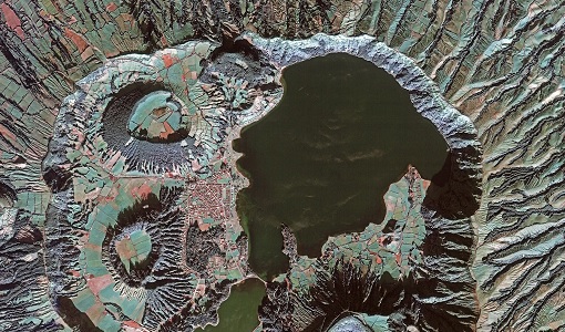
GEOSAT-2 Spain Coverage
The GEOSAT-2 Spain Coverage collection consists of two separate coverages of Spain, including the Balearic and Canary islands, acquired by GEOSAT-2 between March and November of 2021 and 2022, respectively. The available imagery have a geolocation accuracy of < 4 m RMSE, a cloud cover percentage of < 10 %, and were acquired at an off-nadir angle from -30° to 30°. Spatial coverage of the 2021 collection. The following product types are available: Pan-sharpened: A four-band image, resulting from adding the information of each multispectral band to the panchromatic band. The fusion does not preserves all spectral features of the multispectral bands, so it should not be used for radiometric purposes. Resolution 1 m; Bands: All. Bundle: Panchromatic (1 m resolution) + Multispectral bands (4 m resolution): five-band image containing the panchromatic and multispectral products packaged together, with band co-registration. The available processing level is L1C orthorectified: a calibrated and radiometrically corrected product, manually orthorectified and resampled to a map grid. Property Spatial Resolution Pan-sharpened 1.0 m Bundle (PAN + MS) 1.0 m (PAN), 4.0 m (MS)
News - Data Release news
New data available: GEOSAT-2 Portugal Coverage 2021
A new collection is available to the public through ESA’s Earthnet Third Party Missions Programme: the GEOSAT-2 Portugal Coverage 2021.
Data - Fast Registration with approval (Restrained)
GEOSAT-2 Portugal Coverage 2021
GEOSAT-2 Portugal coverage is a collection of 2021 data over the Portugal area, including islands. The available dataset has a cloud cover less than 10%, and is acquired up to 1m resolution with Geometric accuracy <6m CE90 based on Copernicus DEM @10m. GEOSAT-2 Portugal 2021 - Spatial Coverage of the Dataset The following product types are available: Pan-sharpened (4 bands, 321 Natural Colours or 432 False Colours): A four-band image, resulting from adding the information of each multispectral band to the panchromatic band. The fusion does not preserves all spectral features of the multispectral bands, so it should not be used for radiometric purposes. Resolution 1m; Bands: All, R-G-B or Ni-R-G Bundle: Panchromatic (1m resolution) + Multispectral bands (4m resolution): five-band image containing the panchromatic and multispectral products packaged together, with band co-registration. The available processing level is L1C orthorectified: a calibrated and radiometrically corrected product, manually orthorectified and resampled to a map grid. Product Type Processing Level and Spatial Resolution L1B (native) L1C (ortho) Pan-sharpened 1.0m 1.0m Bundle (PAN+MS) 1.0m (P), 4.0m (MS) 1.0m (P), 4.0m(MS)
News - Infographics

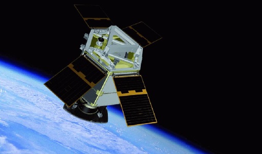
An overview of the GEOSAT-2 high-resolution mission
The GEOSAT series consists of two very high-resolution satellites, capable of acquiring sub-metric multispectral images. The missions are part of ESA's Third Party Missions programme, and GEOSAT-2 is summarised in our latest infographic.
Mission - Heritage Missions
GEOSAT
The GEOSAT series consists of GEOSAT-1 and GEOSAT-2 missions. They are Earth imaging satellites. GEOSAT-2, a high resolution satellite, became the first European fully-private satellite capable of providing sub-metric multi-spectral imagery.
Mission - Heritage Missions
GEOSAT-2
GEOSAT-2 is the second satellite of the Deimos Earth Observation system, following GEOSAT-1.