- All Categories (24)
- Data (1)
- News (6)
- Missions (1)
- Tools (4)
- Activities (1)
- Documents (11)
News - Thematic area articles
Monitoring water on Earth's surface
ESA's Earth observation satellites are playing a leading role in furthering our understanding of how Earth's terrestrial hydrosphere is being influenced by humankind.
News - Thematic area articles
Satellites investigate Earth’s terrestrial hydrosphere
ESA’s Earth observation satellites are playing a leading role in furthering our understanding of how Earth’s water cycle is being influenced by humankind.
Tools - Catalogues
FedEO
FedEO is a data catalogue that provides a unique entry point to a number of scientific catalogues and services for, but not limited to, European and Canadian missions.
Tools - Catalogues
EO CAT
EO CAT is a data catalogue, offering a Next Generation Earth Observation system designed to manage end-user Earth Observation services.
Document - General Reference
Third Party Missions Brochure
This brochure summarises ESA's Third Party Missions programme, providing a timeline and examples of content related to some of the missions.
News - Thematic area articles
Satellite data central to ocean monitoring
Over 95% of Earth’s water is found in our oceans, and yet sadly, oceans are under stress from climate change and pollution. Monitoring our oceans is vital for Earth’s survival and satellites are the primary means of long-term and independent observation of our vast ocean bodies and their associated coastal zones.
News - Infographics
An overview of ESA's Third Party Missions programme
ESA’s Third Party Missions programme consists of almost 50 satellite missions, which are owned by organisations around the world. ESA has agreements with these organisations to acquire, process, and distribute data from their missions
News - Infographics
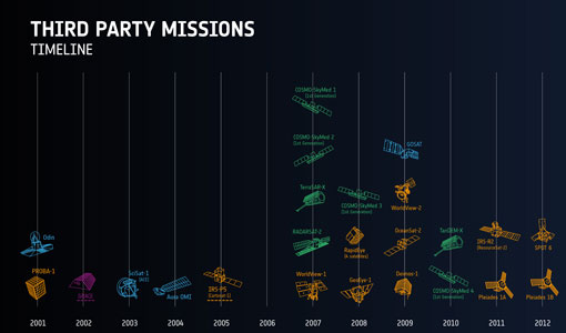
ESA Third Party Missions timeline
We've released a new timeline to illustrate the history of the ESA Third Party Missions.
Document - Technical Note
Technical Note on Quality Assessment for OceanSat-2 (7 Oct 20)
Technical Note on Quality Assessment for OceanSat-2 (7 Oct 20)
Document - Technical Note
Technical Note on Quality Assessment for OceanSat-2 (6 Aug 20)
Technical Note on Quality Assessment for OceanSat-2 (6 Aug 20)
Document - Technical Note
Technical Note on Quality Assessment for OceanSat-2 (1 Jan 19)
Technical Note on Quality Assessment for OceanSat 2 OCM (Quarterly report for Q4 2018)
Document - Technical Note
Technical Note on Quality Assessment for OceanSat-2 (4 Jan 20)
Technical Note on Quality Assessment for OceanSat-2 OCM (Quarterly report for Q3 and Q4 2019)
Document - Technical Note
Technical Note on Quality Assessment for OceanSat-2 (3 Jul 19)
Technical Note on Quality Assessment for OceanSat 2 OCM (Quarterly report for Q2 2019)
Document - Technical Note
Technical Note on Quality Assessment for OceanSat-2 (5 May 20)
Technical Note on Quality Assessment for OceanSat-2 OCM (Quarterly report for Q1 2020)
Document - Technical Note
Technical Note on Quality Assessment for OceanSat-2 (2 Apr 19)
Technical Note on Quality Assessment for OceanSat-2 OCM (Quarterly report for Q1 2019)
Document - User Guide
TPM-L-OADS-dissemination-service-User-Manual.pdf
This guide describes the Third Party Missions Dissemination System.
Data - EO Sign In Authentication (Open)
OceanSat-2 data
ESA, in collaboration with GAF AG, acquired and processed every day OceanSat-2 passes over Neutrelitz reception station from January 2016 to November 2021. All passes were systematically processed to levels 1B, 2B and 2C, and available to users in NRT (< 3 hours). Products are available in: Level 1B: Geophysical Data containing Radiance Data for all 8 Bands of OCM-2 Level 2B: Geophysical Data L2B for given Geo physical parameter. Geo physical parameters: Chlorophyll, Aerosol Depth, Different Attenuation, Total Suspended Sediments Level 2C: Georeferenced Radiance Data for given geo physical parameter. Geo physical parameters: Chlorophyll, Aerosol Depth, Different Attenuation, Total Suspended Sediments. Spatial coverage: Check the spatial coverage of the collection on a map available on the Third Party Missions Dissemination Service.
Activity - Quality
EDAP
The ESA Earthnet Data Assessment Pilot (EDAP) project will perform assessments for various missions to ensure the delivered data is fit for purpose.
Tools - Analysis
SNAP
SNAP is a common architecture for all Sentinel Toolboxes. It is ideal for Earth observation processing and analysis.
Tools - Processing
HDFclean
HDFclean is a programme for reprocessing images stored in the HDF file format. The intended use is to tidy up images of the Earth captured by the CHRIS hyper-spectral imager onboard the PROBA satellite


