- All Categories (30)
- Data (4)
- News (13)
- Events (4)
- Activities (1)
- Documents (8)
News - General News
Go-to guide to Third Party Mission data offering
ESA’s latest Third Party Missions Data Access Guide has been published, providing technical details and information on available data collections for all current or past Third Party Missions.
News - Success Stories
Trailblazing ERS-2 mission enables climate change applications
As ESA’s ERS-2 satellite approaches Earth’s atmosphere for reentry, it’s time to reflect on the mission’s great achievements in powering climate-related applications.
News - Thematic area articles
Global understanding of Earth's land surfaces greatly boosted by satellite data
ESA perform land surface monitoring with a range of instruments onboard satellites acquiring optical and radar data. Collections of data from these missions are freely available for research purposes.
News - Success Stories

Long-term satellite data show wind farms can affect local air currents
Decades of satellite data have allowed for the first long-term study of the impact of offshore wind farms on downstream wind flow in coastal areas.
News - Infographics

The COSMO-SkyMed series - Two generations of SAR satellites
Learn about the COSMO-SkyMed (Constellation of small Satellites for the Mediterranean basin Observation) series in our latest infographic.
Data - EO Sign In Authentication (Open)
PAZ ESA archive
The PAZ ESA archive collection consists of PAZ Level 1 data previously requested by ESA supported projects over their areas of interest around the world and, as a consequence, the products are scattered and dispersed worldwide and in different time windows. The dataset regularly grows as ESA collects new products over the years. Available modes are: StripMap mode (SM): SSD less than 3 m for a scene 30 km x 50 km in single polarization or 15 km x 50 km in dual polarisation ScanSAR mode (SC): the scene is 100 x 150 km2, SSD less than 18 m in signle pol only Wide ScanSAR mode (WS): single polarisation only, with SS less than 40 m and scene size of 270 x 200 km2 Spotlight modes (SL): SSD less than 2 m for a scene 10 km x 10 km, both single and dual polarization are available High Resolution Spotlight mode (HS): in both single and dual polarisation, the scene is 10x5 km2, SSD less than 1 m Staring Spotlight mode (ST): SSD is 25 cm, the scene size is 4 x 4 km2, in single polarisation only. The available geometric projections are: Single Look Slant Range Complex (SSC): single look product, no geocoding, no radiometric artifact included, the pixel spacing is equidistant in azimuth and in ground range Multi Look Ground Range Detected (MGD): detected multi look product, simple polynomial slant-to-ground projection is performed in range, no image rotation to a map coordinate system is performed Geocoded Ellipsoid Corrected (GEC): multi look detected product, projected and re-sampled to the WGS84 reference ellipsoid with no terrain corrections Enhanced Ellipsoid Corrected (EEC): multi look detected product, projected and re-sampled to the WGS84 reference ellipsoid, the image distortions caused by varying terrain height are corrected using a DEM. The following table summarises the offered product types. EO-SIP product type Operation Mode Geometric Projection Geometric Projection PSP_SM_SSC Stripmap (SM) Single Look Slant Range Complex (SSC) PSP_SM_MGD Stripmap (SM) Multi Look Ground Range Detected (MGD) PSP_SM_GEC Stripmap (SM) Geocoded Ellipsoid Corrected (GEC) PSP_SM_EEC Stripmap (SM) Enhanced Ellipsoid Corrected (EEC) PSP_SC_MGD ScanSAR (SC) Multi Look Ground Range Detected (MGD) PSP_SC_GEC ScanSAR (SC) Multi Look Ground Range Detected (MGD) PSP_SC_EEC ScanSAR (SC) Geocoded Ellipsoid Corrected (GEC) PSP_SC_SSC ScanSAR (SC) Enhanced Ellipsoid Corrected (EEC) PSP_SL_SSC Spotlight (SL) Single Look Slant Range Complex (SSC) PSP_SL_MGD Spotlight (SL) Multi Look Ground Range Detected (MGD) PSP_SL_GEC Spotlight (SL) Geocoded Ellipsoid Corrected (GEC) PSP_SL_EEC Spotlight (SL) Enhanced Ellipsoid Corrected (EEC) PSP_HS_SSC High Resolution Spotlight (HS) Single Look Slant Range Complex (SSC) PSP_HS_MGD High Resolution Spotlight (HS) Multi Look Ground Range Detected (MGD) PSP_HS_GEC High Resolution Spotlight (HS) Geocoded Ellipsoid Corrected (GEC) PSP_HS_EEC High Resolution Spotlight (HS) Enhanced Ellipsoid Corrected (EEC) PSP_ST_SSC Staring Spotlight (ST) Single Look Slant Range Complex (SSC) PSP_ST_MGD Staring Spotlight (ST) Multi Look Ground Range Detected (MGD) PSP_ST_GEC Staring Spotlight (ST) Geocoded Ellipsoid Corrected (GEC) PSP_ST_EEC Staring Spotlight (ST) Enhanced Ellipsoid Corrected (EEC) PSP_WS_SSC Wide ScanSAR (WS) Single Look Slant Range Complex (SSC) PSP_WS_MGD Wide ScanSAR (WS) Multi Look Ground Range Detected (MGD) PSP_WS_GEC Wide ScanSAR (WS) Geocoded Ellipsoid Corrected (GEC) PSP_WS_EEC Wide ScanSAR (WS) Enhanced Ellipsoid Corrected (EEC) As per ESA policy, very high-resolution data over conflict areas cannot be provided.
News - Events and Proceedings

Very High Resolution data to take centre stage
In the last few years, European New Space providers have helped strengthen the offering of very high resolution remote sensing data products—a designated workshop this November aims to focus on the latest developments in this arena.
Event - Training

EO Summer School 5
ESA's series of summer schools, on Monitoring of the Earth System, aims to promote the exploitation of Earth observation data.
News - Success Stories

SAR synergy data for maritime surveillance
With the aim of safeguarding our oceans, a recent study uses a synergy of synthetic aperture radar (SAR) images to improve maritime surveillance.
News - Success Stories
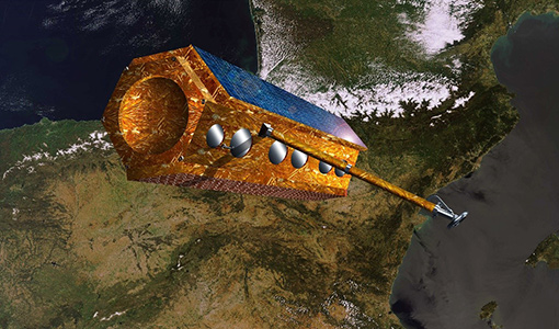
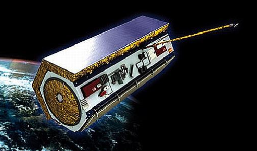
PAZ - Spain's radar success
One way of collecting images in unfavourable weather is to use Synthetic Aperture Radar (SAR). PAZ is one such Earth observation mission capable of delivering all-weather imagery thanks to its X-band SAR.
News - Infographics
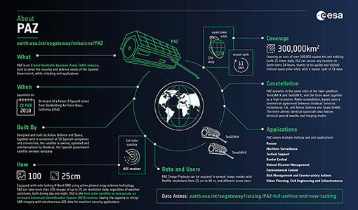
An overview of the PAZ SAR satellite mission
Learn more about the PAZ mission, a Spanish X-Band SAR satellite and part of ESA's Third Party Missions programme, in our latest infographic.
News - Thematic area articles

Satellite data boost global understanding of land surface
Understanding our changing land surface is essential in the study of climate change. Satellites are used to monitor changes to the material that covers Earth’s surface, so-called land cover, such as vegetation and water.
News - Data Release news
New imaging modes added to PAZ collection
Two new imaging modes, Wide ScanSAR and Staring Spotlight, have been added to the PAZ offering and are now available to users for research and application development following submission of a project proposal subject to evaluation and acceptance by ESA and the data owner.
News - Infographics

An overview of ESA's Third Party Missions programme
ESA’s Third Party Missions programme consists of almost 50 satellite missions, which are owned by organisations around the world. ESA has agreements with these organisations to acquire, process, and distribute data from their missions
News - Events and Proceedings

Φ-Week Triumphs
In its fourth edition, Φ-Week presented the scientific community with amazing opportunities and projects—thus running alongside innovation at 360 degrees.
Event - Workshop

SEASAR 2012
The European Space Agency and the Norwegian Space Centre jointly organised the fourth SAR oceanography workshop, 'SEASAR 2012', entitled 'Advances in SAR Oceanography'.
Data - Project Proposal (Restrained)
PAZ Full Archive and New Tasking
PAZ Image Products can be acquired in eight image modes with flexible resolutions (from 1 m to 40 m) and scene sizes. Thanks to different polarimetric combinations and processing levels the delivered imagery can be tailored specifically to meet the requirements of the application. Available modes are: StripMap mode (SM): in single and dual polarisation: The ground swath is illuminated with a continuous train of pulses while the antenna beam is pointed to a fixed angle, both in elevation and in azimuth. ScanSAR mode (SC): in single polarisation: the swath width is increased in respect to the StripMap mode, it is composed of four different sub-swaths, which are obtained by antenna steering in elevation direction Wide ScanSAR mode (WS), in single polarisation: the usage of six sub-swaths allows to obtain a higher swath coverage product Spotlight modes: in single and dual polarisation: Spotlight modes take advantage of the beam steering capability in the azimuth plane to illuminate for a longer time the area of interest: a sensible improvement of the azimuth resolution is achieved at the expense of a shorter scene size. Spotlight mode (SL) is designed to maximise the azimuth scene extension at the expense of the spatial resolution, and High Resolution Spotlight mode (HS) is designed to maximize the spatial resolutions at the expense of the scene extension. Staring Spotlight mode (ST), in single polarisation: The virtual rotation point coincides with the center of the beam: the image length in the flight direction is constrained by the projection on-ground of the azimuth beamwidth and it leads to a target azimuth illumination time increment and to achieve the best azimuth resolution. There are two main classes of products: Spatially Enhanced products (SE): Designed with the target of maximize the spatial resolution in pixels with squared size, so the larger resolution value of azimuth or ground range determines the square pixel size, and the smaller resolution value is adjusted to this size and the corresponding reduction of the bandwidth is used for speckle reduction. Radiometrically Enhanced products (RE): Designed with the target of maximize the radiometry, so the range and azimuth resolutions are intentionally decreased to significantly reduce speckle by averaging several looks. The following geometric projections are offered: Single Look Slant Range Complex (SSC): Single look product of the focused radar signal: the pixels are spaced equidistant in azimuth and in slant range. No geocoding is available, no radiometric artifacts included. Product delivered in the DLR-defined binary COSAR format. The SSC product is intended for applications that require the full bandwidth and phase information, e.g. for SAR interferometry and polarimetry. Multi Look Ground Range Detected (MGD): Detected multi look product in GeoTiff format with reduced speckle and approximately square resolution cells on ground. The image coordinates are oriented along flight direction and along ground range; the pixel spacing is equidistant in azimuth and in ground range. A simple polynomial slant to ground projection is performed in range using a WGS84 ellipsoid and an average, constant terrain height parameter. No image rotation to a map coordinate system is performed and interpolation artifacts are thus avoided. Geocoded Ellipsoid Corrected (GEC): Multi look detected product in GeoTiff format. It is projected and re-sampled to the WGS84 reference ellipsoid assuming one average terrain height. No terrain correction performed. UTM is the standard projection, for polar regions UPS is applied. Enhanced Ellipsoid Corrected (EEC): Multi look detected product in GeoTiff format. It is projected and re-sampled to the WGS84 reference ellipsoid. The image distortions caused by varying terrain height are corrected using an external DEM; therefore the pixel localization in these products is highly accurate. UTM is the standard projection, for polar regions UPS is applied. StripMap Single StripMap Dual ScanSAR Wide ScanSAR Spotlight Single Spotlight Dual HR Spotlight Single HR Spotlight Dual Staring Spotlight Mode ID SM-S SM-D SC WS SL-S SL-D HS-S HS-D ST Polarizations HH, VV, HV, VH HH/VV, HH/HV, VV/VH HH, VV, HV, VH HH, VV, HV, VH HH, VV, HV, VH HH/VV, HH/HV, VV/VH HH, VV, HV, VH HH/VV, HH/HV, VV/VH HH, VV, HV, VH Scene size (Range x Azimuth) [km] 30 x 50 15 x 50 100 x 150 [273-196] x 208 10 x 10 10 x 10 10-6 x 5 (depending on incident angle) 10 x 5 [9-4.6] x [2.7-3.6] Range Resolution [m] MGD, GEC, EEC (SE)[Ground range] 2.99 - 3.52 at (45° - 20°) 6 N/A N/A 1.55 - 3.43 at (55° - 20°) 3.09 - 3.5 at (55° - 20°) 1 - 1.76 at (55° - 20°) 2 - 3.5 at (55° - 20°) 0.96 -1.78 at (45°- 20°) MGD, GEC, EEC (RE) [Ground range] 6.53 - 7.65 at (45° - 20°) 7.51 - 10.43 at (45° - 20°) 16.79 - 18.19 at (45° - 20°) 35 3.51 - 5.43 at (55° - 20°) 4.98 - 7.63 at (55° - 20°) 2.83 - 3.11 at (55° - 20°) 4 - 6.2 at (55° - 20°) 0.97 - 1.78 at (45°-20°) SSC[Slant range] 1.1 (150 MHz bandwidth) 1.7 (100 MHz bandwidth) 1.18 1.17 - 3.4 (depending on range bandwidth) 1.75 - 3.18 (depending on range bandwidth) 1.18 1.17 0.6 1.17 0.59 Azimuth Resolution [m] MGD, GEC, EEC (SE) 3.05 6.11 N/A N/A 1.56 - 2.9 at (55° - 20°) 3.53 1 - 1.49 at (55 °- 20°) 2.38 - 2.93 at (55° - 20°) 0.38 - 0.7 at (45°-20°) MGD, GEC, EEC (RE) 6.53 - 7.60 at (45° - 20°) 7.52 - 10.4 at (45° - 20°) 17.66 - 18.18 at (45° - 20°) 39 3.51 - 5.4 at (55° - 20°) 4.99 - 7.64 at (55° - 20°) 2.83 - 3.13 at (55° - 20°) 4 - 6.25 at (55° - 20°) 0.97 - 1.42 at (45°-20°) SSC 3.01 6.04 18.5 38.27 1.46 3.1 1.05 2.16 0.22 As per ESA policy, very high-resolution data over conflict areas cannot be provided.
Data - Project Proposal (Restrained)
COSMO-SkyMed full archive and tasking
The archive and new tasking X-band SAR products are available from COSMO-Skymed (CSK) and COSMO-SkyMed Second Generation (CSG) missions in ScanSAR and Stripmap modes, right and left looking acquisition (20 to 60° incidence angle). COSMO-SkyMed modes: Acquisition Mode Single look Resolution [Az. X. Rg, SCS] (m) Scene size [Az. X. Rg] (km) Polarisation Scene duration (seconds) Number of looks Multilook resolution (m) Geolocation accuracy ±3 s (m) [DGM, GEC, GTC] Stripmap Himage 2.6 x 3 40 x 40 Single: HH, HV, VH, VV 7 3 5 25 Stripmap PingPong 9.7 x 11 30 x 30 Alternate: HH/VV, HH/HV, VV/VH 6 3 20 25 ScanSAR Wide 23 x 13.5 100 x 100 Single: HH, HV, VH, VV 15 4 - 9 30 30 ScanSAR Huge 38 x 13.5 200 x 200 Single: HH, HV, VH, VV 30 25 - 66 100 100 COSMO-Skymed Second Generation Modes: Acquisition Mode Single look Resolution [Az. X. Rg, SCS] (m) Scene size [Az. X. Rg] (km) Polarisation Scene duration (seconds) Number of looks Multilook resolution (m) Geolocation accuracy ±3σ (m) [DGM, GEC, GTC] Stripmap 3 x 3 40 x 40 Single (HH, VV, HV, VH) or Dual (HH+HV, VV+VH) 7 2 x 2 4 x 4 6 x 7 11 x 14 3.75 Stripmap PingPong 12 x 5 30 x 30 Alternate (HH/VV, HH/HV+VV/VH) 6 1 x 2 2 x 5 12 x 10 23 x 26 12 QuadPol 3 x 3 40 x 15 Quad (HH+HV+VV+VH) N/A 2 x 2 4 x 4 6 x 7 11 x 14 3.75 ScanSAR 1 20 x 4 100 x 100 Single (HH, VV, HV, VH) or Dual (HH+HV, VV+VH) 15 1 x 3 1 x 5 2 x 8 20 x 14 23 x 27 35 x 40 12 ScanSAR 2 40 x 6 200 x 200 Single (HH, VV, HV, VH) or Dual (HH+HV, VV+VH) 30 1 x 4 1 x 7 3 x 16 40 x 27 47 x 54 115 x 135 12 Following Processing Levels are available, for both CSK and CSG: SCS (Level 1A, Single-look Complex Slant): Data in complex format, in slant range projection (the sensor's natural acquisition projection) and zero doppler projection, weighted and radiometrically equalised; the coverage corresponds to the full resolution area illuminated by the SAR instrument DGM (Level 1B, Detected Ground Multi-look): Product obtained detecting, multi-looking and projecting the Single-look Complex Slant data onto a grid regular in ground: it contains focused data, amplitude detected, optionally despeckled by multi-looking approach, radiometrically equalised and represented in ground/azimuth projection GEC (Level 1C, Geocoded Ellipsoid Corrected): Focused data, amplitude detected, optionally despeckled by multi-looking approach, geolocated on the reference ellipsoid and represented in a uniform preselected cartographic presentation. Any geometric correction derived by usage of terrain model isn't applied to this product by default GTC (Level 1D, Geocoded Terrain Corrected): Focused data, fully calibrated with the usage of terrain model, amplitude detected, optionally despeckled by multi-looking approach, geolocated on a DEM and represented in a uniform preselected cartographic presentation. The image scene is located and accurately rectified onto a map projection, through the use of Ground Control Points (GCPs) and Digital Elevation Model (DEM); it differs from GEC for the use of the DEM (instead of reference ellipsoid) for the accurate conversion from slant to ground range and to approximate the real earth surface. The list of available data can be retrieved using the CLEOS COSMO-SkyMed products catalogue. User registration is required to use the catalogue. As per ESA policy, very high-resolution data over conflict areas cannot be provided.
Data - Project Proposal (Restrained)
COSMO-SkyMed ESA archive
The COSMO-SkyMed archive collection consists of COSMO-SkyMed products requested by ESA supported projects over their areas of interest around the world. The dataset regularly grows as ESA collects new products over the years. The following list delineates the characteristics of the SAR measurement modes that are disseminated under ESA Third Party Missions (TPM). STRIPMAP HIMAGE (HIM): Achieving medium resolution (3 m x 3 m single look), wide swath imaging (swath extension ≥40 km). STRIPMAP PINGPONG (SPP): Achieving medium resolution (15 m), medium swath imaging (swath ≥30 km) with two radar polarization's selectable among HH, HV, VH and VV. SCANSAR WIDE (SCW): Achieving radar imaging with swath extension of 100 x 100 km2 and a spatial resolution of 30 x 30 m2. SCANSAR HUGE (SCH): Achieving radar imaging with swath extension of 200 x 200 km2 and a spatial resolution selectable of 100 x 100 m2. Processing Levels: Level 1A - Single-look Complex Slant - (SCSB and SCSU): RAW data focused in slant range-azimuth projection, that is the sensor natural acquisition projection; product contains In-Phase and Quadrature of the focused data, weighted and radiometrically equalised.The processing of the 1A_SCSU product differs from that of the 1A_SCSB product for the following features:a non-weighted processing is performed, which means that windowing isn't applied on the processed bandwidth; radiometric equalisation (in terms of compensation of the range antenna pattern and incidence angle) is not performed; hence only compensation of the antenna transmitter gain and receiver attenuation and range spreading loss is applied. Level 1B - Detected Ground Multi-look (DGM): Product obtained detecting, multi-looking and projecting the Single-look Complex Slant data onto a grid regular in ground. Spotlight Mode products are not multi-looked. Level 1C - Geocoded Ellipsoid Corrected (GEC) and Level 1D - Geocoded Terrain Corrected (GTC): Obtained projecting the Level 1A product onto a regular grid in a chosen cartographic reference system. In case of Lev 1C the surface is the earth ellipsoid while for the Lev 1D a DEM (Digital Elevation Model) is used to approximate the real earth surface. Spatial coverage: Check the spatial coverage of the collection on a map available on the Third Party Missions Dissemination Service. As per ESA policy, very high-resolution data over conflict areas cannot be provided.
Activity - Quality

EDAP
The ESA Earthnet Data Assessment Pilot (EDAP) project will perform assessments for various missions to ensure the delivered data is fit for purpose.