- All Categories (23466)
- Data (33)
- News (98)
- Missions (2)
- Events (24)
- Tools (9)
- Activities (3)
- Campaigns (24)
- Documents (23273)
DATA
Discover and download the Earth observation data you need from the broad catalogue of missions the European Space Agency operate and support.
Data - EO Sign In Authentication (Open)
Sea Ice Thematic Data Product [ALT_TDP_SI]
This is the Sea Ice Thematic Data Product (TDP) V1 resulting from the ESA FDR4ALT project and containing the sea ice related geophysical parameters, along with associated uncertainties: snow depth, radar and sea-ice freeboard, sea ice thickness and concentration. The collection covers data for the ERS-1, ERS-2 and Envisat missions, and bases on Level 1 data coming from previous reprocessing (ERS REAPER and the Envisat V3.0) but taking into account the improvements made at Level 0/Level 1 in the frame of FDR4ALT (ALT FDR). The Sea Ice TDP provides data from the northern or southern hemisphere in two files corresponding to the Arctic and Antarctic regions respectively for the winter periods only, i.e., October to June for the Arctic, and May to November for the Antarctic. For many aspects, the Sea Ice TDP is very innovative: First time series of sea-ice thickness estimates for ERS Homogeneous calibration, allowing the first Arctic radar freeboard time series from ERS-1 (1991) to CryoSat-2 (2021) Uncertainties estimated along-track with a bottom-up approach based on dominant sources ERS pulse blurring error corrected using literature procedure [Peacock, 2004] The FDR4ALT products are available in NetCDF format. Free standard tools for reading NetCDF data can be used. Information for expert altimetry users is also available in a dedicated NetCDF group within the products. Please consult the FDR4ALT Product User Guide before using the data. The FDR4ALT datasets represent the new reference data for the ERS/Envisat altimetry missions, superseding any previous mission data. Users are strongly encouraged to make use of these datasets for optimal results.
Data - EO Sign In Authentication (Open)
Land Ice Thematic Data Product [ALT_TDP_LI]
This is the Land Ice Thematic Data Product (TDP) V1 resulting from the ESA FDR4ALT project and containing estimates of ice sheet surface elevation and associated uncertainties. The collection covers data for three different missions: ERS-1, ERS-2 and Envisat, and based on Level 1 data coming from previous reprocessing (ERS REAPER and the Envisat V3.0) but taking into account the improvements made at Level 0/Level 1 in the frame of FDR4ALT (ALT FDR). The Land Ice TDP focuses specifically on the ice sheets of Greenland and Antarctica, providing these data in different files. For many aspects, the Land Ice Level 2 and Level 2+ processing is very innovative: Improved relocation approach correcting for topographic effects within the beam footprint to identify the Point of Closest Approach Homogeneous timeseries of surface elevation measurements at regular along-track reference nodes. The FDR4ALT products are available in NetCDF format. Free standard tools for reading NetCDF data can be used. Information for expert altimetry users is also available in a dedicated NetCDF group within the products. Please consult the FDR4ALT Product User Guide before using the data. The FDR4ALT datasets represent the new reference data for the ERS/Envisat altimetry missions, superseding any previous mission data. Users are strongly encouraged to make use of these datasets for optimal results.
Data - Sample Data (Open)

CryoSat Data Samples
Download CryoSat data samples from Baseline-B, C, and D products.
Data - EO Sign In Authentication (Open)
PAZ ESA archive
The PAZ ESA archive collection consists of PAZ Level 1 data previously requested by ESA supported projects over their areas of interest around the world and, as a consequence, the products are scattered and dispersed worldwide and in different time windows. The dataset regularly grows as ESA collects new products over the years. Available modes are: StripMap mode (SM): SSD less than 3 m for a scene 30 km x 50 km in single polarization or 15 km x 50 km in dual polarisation ScanSAR mode (SC): the scene is 100 x 150 km2, SSD less than 18 m in signle pol only Wide ScanSAR mode (WS): single polarisation only, with SS less than 40 m and scene size of 270 x 200 km2 Spotlight modes (SL): SSD less than 2 m for a scene 10 km x 10 km, both single and dual polarization are available High Resolution Spotlight mode (HS): in both single and dual polarisation, the scene is 10x5 km2, SSD less than 1 m Staring Spotlight mode (ST): SSD is 25 cm, the scene size is 4 x 4 km2, in single polarisation only. The available geometric projections are: Single Look Slant Range Complex (SSC): single look product, no geocoding, no radiometric artifact included, the pixel spacing is equidistant in azimuth and in ground range Multi Look Ground Range Detected (MGD): detected multi look product, simple polynomial slant-to-ground projection is performed in range, no image rotation to a map coordinate system is performed Geocoded Ellipsoid Corrected (GEC): multi look detected product, projected and re-sampled to the WGS84 reference ellipsoid with no terrain corrections Enhanced Ellipsoid Corrected (EEC): multi look detected product, projected and re-sampled to the WGS84 reference ellipsoid, the image distortions caused by varying terrain height are corrected using a DEM. The following table summarises the offered product types. EO-SIP product type Operation Mode Geometric Projection Geometric Projection PSP_SM_SSC Stripmap (SM) Single Look Slant Range Complex (SSC) PSP_SM_MGD Stripmap (SM) Multi Look Ground Range Detected (MGD) PSP_SM_GEC Stripmap (SM) Geocoded Ellipsoid Corrected (GEC) PSP_SM_EEC Stripmap (SM) Enhanced Ellipsoid Corrected (EEC) PSP_SC_MGD ScanSAR (SC) Multi Look Ground Range Detected (MGD) PSP_SC_GEC ScanSAR (SC) Multi Look Ground Range Detected (MGD) PSP_SC_EEC ScanSAR (SC) Geocoded Ellipsoid Corrected (GEC) PSP_SC_SSC ScanSAR (SC) Enhanced Ellipsoid Corrected (EEC) PSP_SL_SSC Spotlight (SL) Single Look Slant Range Complex (SSC) PSP_SL_MGD Spotlight (SL) Multi Look Ground Range Detected (MGD) PSP_SL_GEC Spotlight (SL) Geocoded Ellipsoid Corrected (GEC) PSP_SL_EEC Spotlight (SL) Enhanced Ellipsoid Corrected (EEC) PSP_HS_SSC High Resolution Spotlight (HS) Single Look Slant Range Complex (SSC) PSP_HS_MGD High Resolution Spotlight (HS) Multi Look Ground Range Detected (MGD) PSP_HS_GEC High Resolution Spotlight (HS) Geocoded Ellipsoid Corrected (GEC) PSP_HS_EEC High Resolution Spotlight (HS) Enhanced Ellipsoid Corrected (EEC) PSP_ST_SSC Staring Spotlight (ST) Single Look Slant Range Complex (SSC) PSP_ST_MGD Staring Spotlight (ST) Multi Look Ground Range Detected (MGD) PSP_ST_GEC Staring Spotlight (ST) Geocoded Ellipsoid Corrected (GEC) PSP_ST_EEC Staring Spotlight (ST) Enhanced Ellipsoid Corrected (EEC) PSP_WS_SSC Wide ScanSAR (WS) Single Look Slant Range Complex (SSC) PSP_WS_MGD Wide ScanSAR (WS) Multi Look Ground Range Detected (MGD) PSP_WS_GEC Wide ScanSAR (WS) Geocoded Ellipsoid Corrected (GEC) PSP_WS_EEC Wide ScanSAR (WS) Enhanced Ellipsoid Corrected (EEC) As per ESA policy, very high-resolution data over conflict areas cannot be provided.
Data - Project Proposal (Restrained)
PAZ Full Archive and New Tasking
PAZ Image Products can be acquired in eight image modes with flexible resolutions (from 1 m to 40 m) and scene sizes. Thanks to different polarimetric combinations and processing levels the delivered imagery can be tailored specifically to meet the requirements of the application. Available modes are: StripMap mode (SM): in single and dual polarisation: The ground swath is illuminated with a continuous train of pulses while the antenna beam is pointed to a fixed angle, both in elevation and in azimuth. ScanSAR mode (SC): in single polarisation: the swath width is increased in respect to the StripMap mode, it is composed of four different sub-swaths, which are obtained by antenna steering in elevation direction Wide ScanSAR mode (WS), in single polarisation: the usage of six sub-swaths allows to obtain a higher swath coverage product Spotlight modes: in single and dual polarisation: Spotlight modes take advantage of the beam steering capability in the azimuth plane to illuminate for a longer time the area of interest: a sensible improvement of the azimuth resolution is achieved at the expense of a shorter scene size. Spotlight mode (SL) is designed to maximise the azimuth scene extension at the expense of the spatial resolution, and High Resolution Spotlight mode (HS) is designed to maximize the spatial resolutions at the expense of the scene extension. Staring Spotlight mode (ST), in single polarisation: The virtual rotation point coincides with the center of the beam: the image length in the flight direction is constrained by the projection on-ground of the azimuth beamwidth and it leads to a target azimuth illumination time increment and to achieve the best azimuth resolution. There are two main classes of products: Spatially Enhanced products (SE): Designed with the target of maximize the spatial resolution in pixels with squared size, so the larger resolution value of azimuth or ground range determines the square pixel size, and the smaller resolution value is adjusted to this size and the corresponding reduction of the bandwidth is used for speckle reduction. Radiometrically Enhanced products (RE): Designed with the target of maximize the radiometry, so the range and azimuth resolutions are intentionally decreased to significantly reduce speckle by averaging several looks. The following geometric projections are offered: Single Look Slant Range Complex (SSC): Single look product of the focused radar signal: the pixels are spaced equidistant in azimuth and in slant range. No geocoding is available, no radiometric artifacts included. Product delivered in the DLR-defined binary COSAR format. The SSC product is intended for applications that require the full bandwidth and phase information, e.g. for SAR interferometry and polarimetry. Multi Look Ground Range Detected (MGD): Detected multi look product in GeoTiff format with reduced speckle and approximately square resolution cells on ground. The image coordinates are oriented along flight direction and along ground range; the pixel spacing is equidistant in azimuth and in ground range. A simple polynomial slant to ground projection is performed in range using a WGS84 ellipsoid and an average, constant terrain height parameter. No image rotation to a map coordinate system is performed and interpolation artifacts are thus avoided. Geocoded Ellipsoid Corrected (GEC): Multi look detected product in GeoTiff format. It is projected and re-sampled to the WGS84 reference ellipsoid assuming one average terrain height. No terrain correction performed. UTM is the standard projection, for polar regions UPS is applied. Enhanced Ellipsoid Corrected (EEC): Multi look detected product in GeoTiff format. It is projected and re-sampled to the WGS84 reference ellipsoid. The image distortions caused by varying terrain height are corrected using an external DEM; therefore the pixel localization in these products is highly accurate. UTM is the standard projection, for polar regions UPS is applied. StripMap Single StripMap Dual ScanSAR Wide ScanSAR Spotlight Single Spotlight Dual HR Spotlight Single HR Spotlight Dual Staring Spotlight Mode ID SM-S SM-D SC WS SL-S SL-D HS-S HS-D ST Polarizations HH, VV, HV, VH HH/VV, HH/HV, VV/VH HH, VV, HV, VH HH, VV, HV, VH HH, VV, HV, VH HH/VV, HH/HV, VV/VH HH, VV, HV, VH HH/VV, HH/HV, VV/VH HH, VV, HV, VH Scene size (Range x Azimuth) [km] 30 x 50 15 x 50 100 x 150 [273-196] x 208 10 x 10 10 x 10 10-6 x 5 (depending on incident angle) 10 x 5 [9-4.6] x [2.7-3.6] Range Resolution [m] MGD, GEC, EEC (SE)[Ground range] 2.99 - 3.52 at (45° - 20°) 6 N/A N/A 1.55 - 3.43 at (55° - 20°) 3.09 - 3.5 at (55° - 20°) 1 - 1.76 at (55° - 20°) 2 - 3.5 at (55° - 20°) 0.96 -1.78 at (45°- 20°) MGD, GEC, EEC (RE) [Ground range] 6.53 - 7.65 at (45° - 20°) 7.51 - 10.43 at (45° - 20°) 16.79 - 18.19 at (45° - 20°) 35 3.51 - 5.43 at (55° - 20°) 4.98 - 7.63 at (55° - 20°) 2.83 - 3.11 at (55° - 20°) 4 - 6.2 at (55° - 20°) 0.97 - 1.78 at (45°-20°) SSC[Slant range] 1.1 (150 MHz bandwidth) 1.7 (100 MHz bandwidth) 1.18 1.17 - 3.4 (depending on range bandwidth) 1.75 - 3.18 (depending on range bandwidth) 1.18 1.17 0.6 1.17 0.59 Azimuth Resolution [m] MGD, GEC, EEC (SE) 3.05 6.11 N/A N/A 1.56 - 2.9 at (55° - 20°) 3.53 1 - 1.49 at (55 °- 20°) 2.38 - 2.93 at (55° - 20°) 0.38 - 0.7 at (45°-20°) MGD, GEC, EEC (RE) 6.53 - 7.60 at (45° - 20°) 7.52 - 10.4 at (45° - 20°) 17.66 - 18.18 at (45° - 20°) 39 3.51 - 5.4 at (55° - 20°) 4.99 - 7.64 at (55° - 20°) 2.83 - 3.13 at (55° - 20°) 4 - 6.25 at (55° - 20°) 0.97 - 1.42 at (45°-20°) SSC 3.01 6.04 18.5 38.27 1.46 3.1 1.05 2.16 0.22 As per ESA policy, very high-resolution data over conflict areas cannot be provided.
Data - Campaigns (Open)

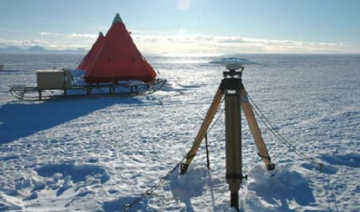
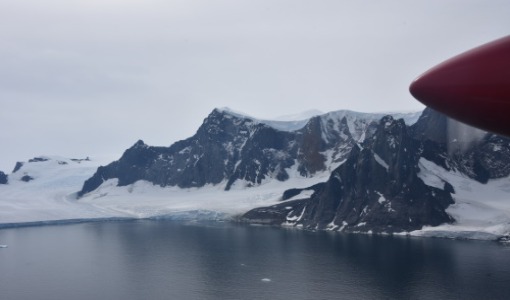
CryoVExAnt 2010/2011
The CryoVEx 2010/2011 Antartic campaign was carried out in Dronning Maud Land from 11 November 2010 to 20 February 2011.
Data - Campaigns (Open)
CryoVExAnt 2008/2009
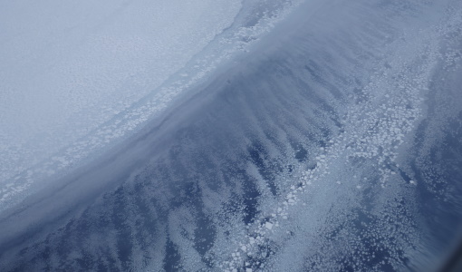
The key objective of the CryoSat Validation Experiment Antarctica (CryoVExAnt) campaign is a better approximation of the error range of the elevation obtained from SAR-processed altimetric radar returns and its sensitivity to surface roughness.
Data - Fast Registration with immediate access (Open)
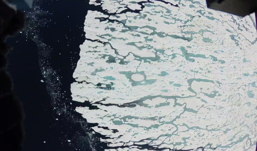
ERS-1/2 SCATTEROMETER Ocean Wind field and Sea Ice probability [ASPS20.H/ASPS20.N]
The ASPS Level 2 products contain, for each node: the radar backscattering sigma nought for the three beams of the instrument, the four aliased wind solutions (Rank 1-4 wind vector) and the de-aliased wind vector flag, the sea-ice probability and sea-ice flag, the YAW quality flag. The wind retrieval is performed with the CMOD5N geophysical model function derived by ECMWF to compute the neutral winds rather than 10 m winds. ASPS L2.0 High resolution products are provided with a spatial resolution of 25x25 km and a grid spacing of 12.5 km. ASPS L2.0 Nominal resolution products are provided with a spatial resolution of 50x50 km and a grid spacing of 25 km. One product covers one orbit from ascending node crossing. Please consult the Product Quality Readme file before using the ERS ASPS data.
Data - EO Sign In Authentication (Open)
ERS-1/2 SAR IM Precision L1 [SAR_IMP_1P]
The SAR Precision product is a multi-look (speckle-reduced), ground range image acquired in Image Mode. This product type is most applicable to users interested in remote sensing applications, but is also suitable for calibration purposes. The products are calibrated and corrected for the SAR antenna pattern and range-spreading loss. Radar backscatter can be derived from the products for geophysical modelling, but no correction is applied for terrain-induced radiometric effects. The images are not geocoded, and terrain distortion (foreshortening and layover) has not been removed. The numbering sequence relates to the satellite position and therefore differs between Ascending and Descending scenes. Product characteristics: Pixel size: 12.5 m (range - across track) x 12.5 m (azimuth - along track) Scene area: 100 km (range) x at least 102.5 km (azimuth) Scene size: 8000 pixels range x at least 8200 lines (azimuth) Pixel depth: 16 bits unsigned integer Total product volume: 125 MB Projection: Ground-range Number of looks: 3.
Data - EO Sign In Authentication (Open)
ERS-1/2 SAR IM Single Look Complex L1 [SAR_IMS_1P]
The SAR SLC product is a single look complex acquired in Image Mode. It is a digital image, with slant range and phase preserved, generated from raw SAR data using up-to-date auxiliary parameters. The products are intended for use in SAR quality assessment, calibration and interferometric applications. A minimum number of corrections and interpolations are performed on the data. Absolute calibration parameters (when available) are provided in the product annotation. Product characteristics: Pixel size: 8 m (range - across track) x 4 m (azimuth - along track – varying slightly depending on acquisition Pulse Repetition Frequency) Scene area: 100 km (range) x at least 102.5 km (azimuth) Scene size: 5000 samples (range) x at least 30000 lines (azimuth) Pixel depth: 32 bits signed integer (16 bits I, 16 bits Q) Total product volume: 575 MB Projection: Slant range- Number of looks: 1.
Data - Data Service Request (Restrained)
ERS-1/2 SAR IM L0 [SAR_IM__0P]
This SAR Level 0 product is acquired in Image Mode. The products consist of the SAR telemetry data and are supplied as standard scenes. It also contains all the required auxiliary data necessary for data processing. The product serves two main purposes: For testing ERS SAR processors independently from the HDDR system For users interested in full SAR data processing. Product characteristics: Scene area: 100 km (range - across track) x full segment length (azimuth - along track) Scene size: 5616 samples (range) x full segment length (azimuth) Pixel depth: 10 bits signed integer (5 bits I, 5 bits Q) Projection: Slant range.
Data - EO Sign In Authentication (Open)
ERS-1/2 SAR IM Medium Resolution L1 [SAR_IMM_1P]
This ERS Medium Resolution stripline product is generated from the Image Mode Level 0 Product. Stripline image products contain image data for an entire segment, up to a maximum size of 10 minutes per product for IM mode. The processor concatenates together several sub-images called "slices" that were processed separately on a dataset-by-dataset basis in order to form the entire stripline image. The product is processed to an approximately 150 m x 150 m resolution and has a radiometric resolution that is good enough for ice applications. This product has a lower spatial resolution than the SAR_IMP_1P and SAR_IMS_1P products. Product Characteristics: Pixel size: 5 m (ground range – across track) x 75 m (azimuth – along track) Scene area: 100 km (range) x at least 102.5 km Scene Size: 1300 pixels (range) x at least 1350 lines (azimuth) Pixel depth: 16 bits unsigned integer- Total product volume: at least 3.5 MB Projection: Ground-range Number of looks: 8 (azimuth) x 7 (range).
Data - Open access (Open)
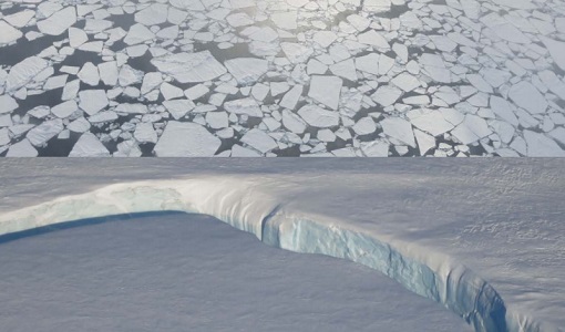
CryoSat products
CryoSat's primary payload is the SAR/Interferometric Radar Altimeter (SIRAL) which has extended capabilities to meet the measurement requirements for ice-sheet elevation and sea-ice freeboard. CryoSat also carries three star trackers for measuring the orientation of the baseline. In addition, a radio receiver called Doppler Orbit and Radio Positioning Integration by Satellite (DORIS) and a small laser retroreflector ensures that CryoSat's position will be accurately tracked. More detailed information on CryoSat instruments is available on the CryoSat mission page. The following CryoSat datasets are available and distributed to users: Level 1B and L2 Ice products: NRT, LRM, SAR and SARIn Consolidated Level 2 (GDR): (LRM+SAR+SARIN) consolidated ice products over an orbit Intermediate Level 2 Ice products: LRM, SAR and SARIn L1b and L2 Ocean Products: NOP, GOP and IOP Cryo-TEMPO Land Ice Cryo-TEMPO Sea Ice Cryo-TEMPO Coastal Ocean Cryo-TEMPO Polar Ocean Cryo-TEMPO Inland Waters Cryo-TEMPO EOLIS Point Products Cryo-TEMPO EOLIS Gridded Products CryoSat Quaternions Product. Detailed information concerning each of the above datasets is available in the CryoSat Products Overview. CryoSat Ice and Ocean products CryoSat Level 1B altimetric products contain time and geo-location information as well as SIRAL measurements in engineering units. Calibration corrections are included and have been applied to the window delay computations. In Offline products, geophysical corrections are computed from Analysis Auxiliary Data Files (ADFs), whereas in FDM products corrections are computed for Forecast ADFs. All corrections are included in the data products and therefore the range can be calculated by taking into account the surface type. The Offline Level 2 LRM, SAR and SARIn ice altimetric products are generated 30 days after data acquisition and are principally dedicated to glaciologists working on sea-ice and land-ice areas. The Level 2 FDM products are near-real time ocean products, generated 2-3 hours after data acquisition, and fulfill the needs of some ocean operational services. Level 2 products contain the time of measurement, the geo-location and the height of the surface. IOP and GOP are outputs of the CryoSat Ocean Processor. These products are dedicated to the study of ocean surfaces, and provided specifically for the needs of the oceanographic community. IOP are generated 2-3 days after data sensing acquisition and use the DORIS Preliminary Orbit. GOP are typically generated 30 days after data sensing acquisition and use the DORIS Precise Orbit. Geophysical corrections are computed from the Analysis ADFs, however following the oceanographic convention the corrections are available but not directly applied to the range (as for FDM). CryoSat Ice and Ocean products can be accessed through ftp://science-pds.cryosat.esa.int/ via an FTP client and HTTPS under the folders named “SIR_” followed by the data product type and the processing level (e.g., SIR_SAR_L2 for Level 2 SAR data). Additionally, data can be downloaded from all the other services listed in the How to Access Data section. Cryo-TEMPO Products The CryoSat ThEMatic PrOducts (Cryo-TEMPO) projects aim to deliver a new paradigm of simplified, harmonized, and agile CryoSat-2 products, that are easily accessible to new communities of non-altimeter experts and end users. The Cryo-TEMPO datasets include dedicated products over five thematic areas, covering Sea Ice, Land Ice, Polar Ocean, Coastal Ocean and Inland Water. The standard Cryo-TEMPO products include fully-traceable uncertainties and use rapidly evolving, state-of-the-art processing dedicated to each thematic area. Throughout the project, the products will be constantly evolved, and validated by a group of Thematic Users, thus ensuring optimal relevance and impact for the intended target communities. More information on the Cryo-TEMPO products can be found in the Product Handbook and on the Project Website. The products can be accessed through ftp://science-pds.cryosat.esa.int/ via an FTP client and HTTPS under the folders named “TEMPO_POCA_(SI/LI/PO/CO/IW)", where the last two letters are the initials of the thematic area (e.g., SI stands for Sea Ice). Cryo-TEMPO EOLIS The CryoTEMPO-EOLIS swath product exploits CryoSat's SARIn mode and the novel Swath processing technique to deliver increased spatial and temporal coverage of time-dependent elevation over land ice, a critical metric for tracking ice mass trends in support to a wide variety of end-users. The dataset consists of systematic reprocessing of the entire CryoSat archive to generate new L2-Swath products, increasing data sampling by 1 to 2 orders of magnitude compared with the operational L2 ESA product. In addition, the EOLIS dataset is joined with the ESA L2 Point-Of-Closest-Approach to generate monthly DEM (Digital Elevation Model) products. This dataset will further the ability of the community to analyse and understand trends across the Greenland Ice Sheet margin, Antarctica and several mountain glaciers and ice caps around the world. More information on the Cryo-TEMPO products can be found on the Project Website and the products can be accessed through ftp://science-pds.cryosat.esa.int/ via an FTP client and HTTPS under the folders named “TEMPO_SWATH_(POINT/GRID)”, where the last word is used to choose between the available “Point” and “Gridded” datasets. Additionally, Cryo-TEMPO EOLIS products can be visualised and downloaded from the CS2EO Platform. CryoSat Quaternions Product This product contains the attitude quaternions for the CryoSat-2 mission. It is obtained starting from the corrected mispointing angles measured by the platform star trackers. More information on the product can be found in the Algorithm Description and Product Format Specification documents. The quaternions product can be accessed from the CryoSat CalVal FTPS server via an FTPS client, and are located in the “AUX_PROQUA” folder. Users wishing to access the quaternions products should request a personal account to be created by emailing the CryoSat Mission Geophysicist, Dr. Alessandro Di Bella (alessandro.di.bella@ext.esa.int).
Data - Campaigns (Open)
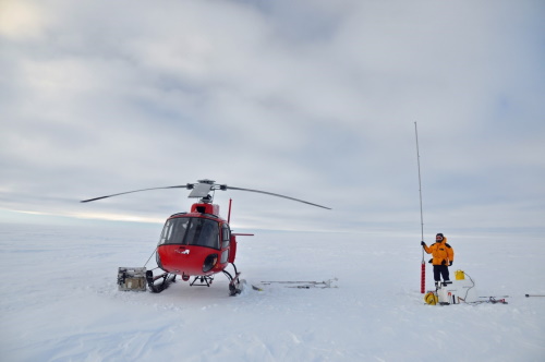
CryoVEx/ICESat-2 Spring 2019
The ESA Spring CryoVEx/ICESat-2 campaign 2019 was the first CryoVEx campaign since the launch of NASA ICESat-2 in September 2018, and aimed at cross-validating ESA CryoSat-2 and NASA ICESat-2 missions over sea ice and land ice in the Arctic.
Data - Campaigns (Open)
CryoVEx KAREN 2017
The CryoVEx-KAREN 2017 Campaign in the Arctic had the goal to collect unique measurements to help us better understand how sea ice is changing.
Data - Campaigns (Open)
CryoVEx KAREN 2016 Fall
The CryoVEx-KAREN 2016 Fall Campaign in Ilulissat, Greenland had the goal to collect unique measurements to help us better understand how snow and ice on the Greenland ice sheet is changing over time, and help ESA design future space missions to monitor the changing climate in our polar regions.
Data - Campaigns (Open)
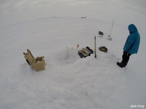
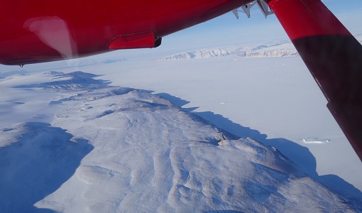
CryoVEx/KAREN Antarctica 2017/18
ESA’s CryoVEx/Karen 2017‐18 campaign took place in Antarctica in from Dec 2017 to Jan 2018. The campaign was composed of an airborne and in‐situ campaign and acquired extensive data sets of scanning lidar, Ku‐ and Ka‐band nadir‐looking radar, and auxiliary imagery for validation of the ESA CryoSat‐2 satellite (Ku‐band radar altimetry) and the French‐Indian AltiKa mission (Ka‐band radar altimetry).
Data - Campaigns (Open)
CryoVEx ICESat-2 Summer 2019
The ESA CryoVEx/ICESat‐2 summer campaign 2019 is an add‐on to the campaign carried out in the spring 2019, which did not cover all the flights that were planned due to weather obstacles.
Data - Campaigns (Open)
CryoVEx ASIRAS 2014
The CryoVEx 2014 airborne campaign was conducted as two separate operational periods. The sea ice activities covering large parts of the western Arctic Ocean were planned to take place early in the season to make sure the weather was stable.
Data - Campaigns (Open)
CryoVEx 2016 Spring
The CryoVEx 2016 campaign was primarily carried out to follow up on a recommendation given within ESA CryoVal Land Ice project (2014-2015), where it was found that the traditional under-flights of the CryoSat-2 satellite were inadequate.