- All Categories (43829)
- Data (196)
- News (346)
- Missions (79)
- Events (111)
- Tools (21)
- Activities (30)
- Campaigns (79)
- Documents (42967)
ACTIVITIES
Find the activities you need.
Activity - Projects
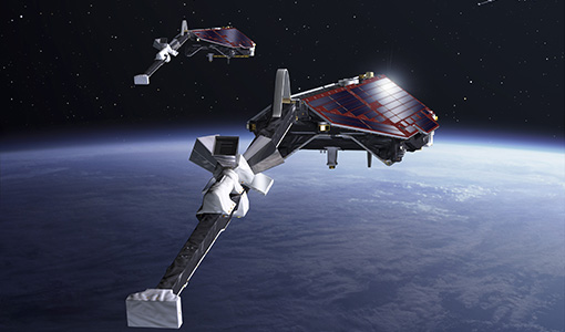
Average Magnetic field and Polar current System model
The AMPS project outcome is a new climatological model of polar ionospheric currents, based on magnetic field measurements from the CHAMP and Swarm satellites.
Activity - Projects

Contribution of Swarm data to the prompt detection of Tsunamis and other natural hazards
The main objective of COSTO (Contribution of Swarm data to the prompt detection of Tsunamis and other natural hazards) project is to better characterise, understand and discover coupling processes and interactions.
Activity - Projects
Dragon 2 Cooperation Programme
The Dragon 2 Programme focussed on the exploitation of ESA, ESA's Third Party Missions and Chinese Earth observation data for science and applications development in land, ocean and atmospheric applications.
Activity - Projects
Dragon Cooperation Programme
The Dragon Programme focussed on science and applications development in China using mainly data from the ERS and Envisat missions. The Prgramme was a cooperation between ESA and the National Remote Sensing Centre of China.
Activity - Quality

EDAP
The ESA Earthnet Data Assessment Pilot (EDAP) project will perform assessments for various missions to ensure the delivered data is fit for purpose.
Activity - General activities

EO Science for Society
ESA's Earth Observation Science for Society programme aims to promote scientific exploitation of satellite data, forges new scientific discoveries and pioneers new services, stimulating downstream industrial and economic growth.
Activity - General activities
EO Summer Schools
ESA's series of summer schools, on Monitoring of the Earth System, aims to promote the exploitation of Earth observation (EO) data.
Activity - Instrument characterisation and algorithm studies

ESA satellites and instruments calibration landing page
ESA satellites and instruments calibration landing page.
Activity - Fiducial Reference Measurements
FRM-BOUSSOLE: Buoy for the acquisition of long-term optical time series
The purpose of the BOUSSOLE project is to establish a time series of optical properties in oceanic waters, in support to bio-optics research.
Activity - Fiducial Reference Measurements
FRM4ALT: Fiducial Reference Measurements for Altimetry
The aim of the FRM4ALT Project. precise measurements of the surface topography of the ocean, and of continental waters are made through satellite altimetry missions all over the globe.
Activity - Fiducial Reference Measurements
FRM4GHG: Reference Measurements for Ground-Based FTIR Greenhouse Gas Observation
Fiducial Reference Measurements for Ground-Based Infrared Greenhouse Gas Observations (FRM4GHG) is a European Space Agency (ESA) funded project.
Activity - Fiducial Reference Measurements
FRM4SOC: Fiducial Reference Measurements for Satellite Ocean Colour
The FRM4SOC project, with funding from ESA, has been structured to provide support for evaluating and improving the state of the art in ocean colour validation .
Activity - Fiducial Reference Measurements
FRM4STS: Fiducial Reference Measurements for validation of Surface Temperatures
FRM4STS is an ESA funded project, to establish and maintain SI traceability of global Fiducial Reference Measurements (FRM) for satellite derived surface temperature product validation.
Activity - Fiducial Reference Measurements
FRM4VEG: Fiducial Reference Measurements for Vegetation
Fiducial Reference Measurements for Vegetation (FRM4VEG) is an ESA managed project focused on establishing the protocols required for traceable in-situ measurements of vegetation
Activity - General activities

International Charter Space and Major Disasters
Learn about the International Charter Space and Major Disasters, which ESA participate in disaster monitoring.
Activity - Quality
LTDP ALTS: ATSR Long Term Stability Project
The LTDP ALTS: ATSR Long Term Stability Project is designed to explore new and innovative ways of enhancing the (A)ATSR data set.
Activity - Projects
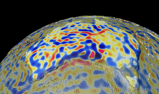
Magnetic oceans and electric Earth
The Magnetic Tidal Signals and Their Use in Mapping the Electrical Conductivity of the Lithosphere and Upper Mantle project aimed to use the magnetic fields produced from ocean tides to probe the conductivity of Earth's lithosphere and upper mantle.
Activity - Cal/Val activities
MBASSS
Mer Bleue Arctic Surrogate Simulation Site (MBASSS) Sentinel-2 and Landsat 8 Validation Project objectives are to develop capability to validate Landsat 8 Operational Land Imager land data products.
Activity - General activities

MUltisource data package tools and SErvices (MUSE)
The MUSE project aims to develop and integrate a tool to simultaneously manipulate geospatial data products, satellite, model and in-situ data.
Activity - Projects

PUMAS Initiative
The Promotion of Utilisation and Mission Applications and Science (PUMAS) is a joint initiative between ESA and CONAE (the Argentinian Space Agency). Established in 2021, PUMAS organises collaborative activities between the two agencies in the field of Earth observation.