- All Categories (42884)
- Data (163)
- News (260)
- Missions (58)
- Events (81)
- Tools (19)
- Activities (23)
- Campaigns (69)
- Documents (42211)
ACTIVITIES
Find the activities you need.
Activity - Projects
TIRO
Topside Ionosphere Radio Observations from multiple LEO-missions (TIRO) project will provide two measurements from onboard instruments of LEO satellite missions: TEC (Total Electron Content) derived from GNSS signals, and electron density derived from KBR (K-Band Ranging) system observations.
Activity - Projects

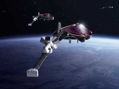
Swarm LP Ion Drift and Effective Mass
The Swarm LP Ion Drift and Effective Mass (SLIDEM) project will augment Swarm's ability to measure the along-track component of ion drift, and assess the composition of ionospheric ions.
Activity - Quality
SLAP
The SLAP (Systematic Landsat Archive Processing) project covers the MSS, TM and ETM+ products from Landsat missions 1 – 7, and is the first systematic reprocessing of the ESA Landsat archive.
Activity - Projects
SIEMIC
Swarm Investigation of the Energetics of Magnetosphere-Ionosphere Coupling (SIEMIC) project is a Living Planet Fellowship research project to discover how much energy flows from the magnetosphere to the ionosphere at which scales into each hemisphere.
Activity - Quality
SEOM CAWA
The Advanced Clouds, Aerosols and WAter vapour products for Sentinel-3/OLCI project aims to develop and improve the advanced atmospheric retrieval algorithms developed for MERIS and OLCI instruments.
Activity - Quality
SCIRoCCo
The SCIRoCCo project is an interdisciplinary cooperation of scatterometry experts aimed at promoting the continuing exploitation of ESA's unique 20 years' worth of ERS Scatterometer data.
Activity - Quality
REAPER
The REAPER (REprocessing of Altimeter Products for ERS) project covers both the ERS-1 and the ERS-2 altimetry missions. The project aims to support and maintain data quality.
Activity - Projects

PUMAS Initiative
The Promotion of Utilisation and Mission Applications and Science (PUMAS) is a joint initiative between ESA and CONAE (the Argentinian Space Agency). Established in 2021, PUMAS organises collaborative activities between the two agencies in the field of Earth observation.
Activity - Projects
Plasmapause Related boundaries in the topside Ionosphere as derived from Swarm Measurements
In the project, Plasmapause Related boundaries in the topside Ionosphere as determined from Swarm Measurements (PRISM), the team develop products that characterise position of the plasmapause related phenomena in the topside ionosphere.
Activity - General activities

MUltisource data package tools and SErvices (MUSE)
The MUSE project aims to develop and integrate a tool to simultaneously manipulate geospatial data products, satellite, model and in-situ data.
Activity - Projects
Magnetic oceans and electric Earth
The Magnetic Tidal Signals and Their Use in Mapping the Electrical Conductivity of the Lithosphere and Upper Mantle project aimed to use the magnetic fields produced from ocean tides to probe the conductivity of Earth's lithosphere and upper mantle.
Activity - Projects
Ionospheric signature of auroral and subauroral fast flows
The ionospheric signature of auroral and subauroral fast flows project aims to advance the understanding of narrow regions of fast flow in the auroral and subauroral regions.
Activity - General activities

International Charter Space and Major Disasters
Learn about the International Charter Space and Major Disasters, which ESA participate in disaster monitoring.
Activity - Fiducial Reference Measurements
FRM4STS: Fiducial Reference Measurements for validation of Surface Temperatures
FRM4STS is an ESA funded project, to establish and maintain SI traceability of global Fiducial Reference Measurements (FRM) for satellite derived surface temperature product validation.
Activity - Fiducial Reference Measurements
FRM4SOC: Fiducial Reference Measurements for Satellite Ocean Colour
The FRM4SOC project, with funding from ESA, has been structured to provide support for evaluating and improving the state of the art in ocean colour validation .
Activity - Fiducial Reference Measurements
FRM4ALT: Fiducial Reference Measurements for Altimetry
The aim of the FRM4ALT Project. precise measurements of the surface topography of the ocean, and of continental waters are made through satellite altimetry missions all over the globe.
Activity - Fiducial Reference Measurements
FRM-BOUSSOLE: Buoy for the acquisition of long-term optical time series
The purpose of the BOUSSOLE project is to establish a time series of optical properties in oceanic waters, in support to bio-optics research.
Activity - General activities
EO Summer Schools
ESA's series of summer schools, on Monitoring of the Earth System, aims to promote the exploitation of Earth observation (EO) data.
Activity - General activities

EO Science for Society
ESA's Earth Observation Science for Society programme aims to promote scientific exploitation of satellite data, forges new scientific discoveries and pioneers new services, stimulating downstream industrial and economic growth.
Activity - Quality

EDAP
The ESA Earthnet Data Assessment Pilot (EDAP) project will perform assessments for various missions to ensure the delivered data is fit for purpose.