- All Categories (954)
- Data (1)
- News (3)
- Missions (2)
- Tools (1)
- Activities (1)
- Documents (946)
Data - Announcement of Opportunity (Restrained)
Announcement of Opportunity for S3VT (Sentinel-3 Validation Team)
In the framework of a Copernicus collaborative agreement ESA and EUMETSAT invite interested groups and individuals to support the Sentinel-3 Validation Team (S3VT).
Activity - Projects
Dragon 2 Cooperation Programme
The Dragon 2 Programme focussed on the exploitation of ESA, ESA's Third Party Missions and Chinese Earth observation data for science and applications development in land, ocean and atmospheric applications.
News - Data Release news
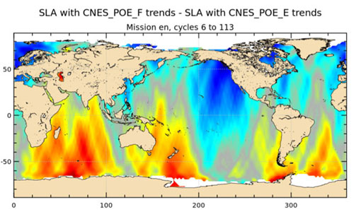
Release of new Envisat DORIS Precise Orbit data
A new version of the Envisat Precise Orbit products has been generated by the Centre de Traitement Doris Poseidon (CTDP) using the Geophysical Data Records F standards (GDR-F). The new dataset (DOR_VOR_AX vF) is now available to users in Envisat format from the ESA dissemination service.
Tools - Apps
Heritage Missions app for Android
Download the Heritage Missions application to discover what the missions were about, how it worked and what the elements of the space and ground segment that make these missions unique.
Mission - Copernicus Sentinels
Copernicus Sentinel-3
Copernicus Sentinel-3 is an European Earth Observation satellite mission developed to support Copernicus ocean, land, atmospheric, emergency, security and cryospheric applications.
Document - Product Specifications
Envisat products specifications - Volume 9 - DORIS products specifications
Mission - Heritage Missions
Envisat
Envisat was ESA's successor to ERS. Envisat carried ten instruments aboard for a wide range of Earth observing fields. The mission was operational from 2002 to 2012.
News - Data Release news
Updated Precise Orbit data (POD) for the full ERS-1 and ERS-2 mission available
The Precise Orbit files (ERS.ORB.POD) for the entire ERS-1 and ERS-2 mission periods have been reprocessed with up-to-date standards.
News - Success Stories
Spotlight on sea-level rise
Scientists to share findings on how satellite has revealed changes in the height of the sea, ice, inland bodies of water and more.
Document - General Reference
A-Review-of-Mediterranean-Environmental-Management-Actions-Using-Space-Techniques.pdf
This document represents the executive review of the work performed by CTM (Centro di Telerilevamento Mediterraneo) and the National Observatory of Athens. This review has been promoted by ESA - EURISY Colloquium (Athens, 19-20 October 1998)
Document - General Reference
A-New-Earth-Explorer-The-Third-Cycle-of-Core-Earth-Explorers.pdf
This article is extracted from ESA Bulletin Nr. 131
Document - Product Document
ERS-Ground-Stations-Products-Specification.pdf
This document defines all outgoing products generated by the ERS-1 and ERS-2 Ground Stations at: Kiruna, Fucino, Maspalomas, Gatineau and Prince Albert. Products are defined in terms of their structure, content and format. Distribution media are defined in terms of their type and format.
Document - Product Document
ERS-Products-WMO-FM94-BUFR-Format.pdf
This document defines all the products distributed by ESA/ESRIN for transmission over the World Meteorological Organisation (WMO) Global Telecommunication System (GTS). Products are defined in terms of their structure, content and format.
Document - Product Cal/Val Plan/Report
ERS-2-Rapid-Products-Validation.pdf
This note shortly summarizes the validation activities for the new rapid orbit and altimeter products RPD/ROPR for ERS-2. Besides internal quality measures the products are compared with the operational Preliminary Orbit (PRL) and the Quick-Look Ocean Product Records (QLOPR).
Document - Technical Note
Envisat-Satellite-Qualification-Review-Data-Package-Volume-1K-Supporting-ESQR-Documents.pdf
This volume is the first of a 15 volume set of documents that comprises the Payload to Ground Segment Interface Control Document (PGICD). Volume 1 provides introductory information that is needed to understand both the purpose and scope of the PGICD as well as the concept of breaking the document into individual volumes.
Document - Technical Note
Envisat-products-specifications-VOLUME-17-EXTRACTED-INSTRUMENT-HEADERS.pdf
This file presents the Product Quality Readme (PQR) information for the AATSR Level 1b (ATS_TOA_1P) products. All PQRs are retained for reference in this file, even those pertaining to historically available datasets only, hence there is an explicit statement in each PQR noting whether it is still applicable to the most recent AATSR dataset.
Document - Technical Note
CUS-Software-Administrator-and-Operator-Manual.pdf
This document describes all procedures to be executed by administrators and operators in order to support correct activities of CUS facility.
Document - Technical Note
ESOWG7-ERS-National-&-Foreign-Stations-Operators-Working-Group.pdf
This document presents material from the 7th ERS National and Foreign Stations Operators Working Group Meeting, which took place in Toulouse, France, from 28 to 29 May 1998.
Document - Technical Note
F-PAC-User-Services.pdf
This document provides details on the user services set up in place at the F-PAC to insure data dissemination services. Both electronic and media dissemination are covered by this document.
Document - Technical Note
RA-Characterisation-Data.pdf
This document can be regarded as a first issue of the long-awaited RA Characterisation Database. It contains values for all parameters which have been requested, except for some special cases which will be explained later. It contains many other parameters as well. For example it also contains all the parameters used in the LRDPF (and referred to in ER-RP-DSF-SY-0007) except for the parameters forseen to be updated frequently, such as the barometric pressure field (which will come from ECMWF).


