- All Categories (40)
- Data (3)
- News (11)
- Missions (3)
- Events (11)
- Tools (3)
- Activities (1)
- Campaigns (2)
- Documents (6)
News - Thematic area articles
How to use space data to probe humankind’s ancient past
Data disseminated by ESA’s Third Party Missions (TPM) programme are enabling archaeological investigations that could help to unravel the mysteries of past societies and cultures.
News - Success Stories
Synergy of space data helps modernise irrigation systems
The growing demands on agriculture, coupled with the climate crisis, are pressurising Earth’s valuable freshwater resources and making assessment of water practices ever more important.
News - General News
Stunning new features for ESA and NASA altimetry portal cs2eo.org
Working with combined ESA and NASA altimetry data is easier than ever thanks to a range of handy new features on cs2eo.org.
News - Success Stories
Space data unearths small-scale mining in Burkina Faso
Satellite data from ESA’s Pléiades Third Party Mission and Copernicus Sentinel-2 were used to demonstrate that deep learning models can accurately and inexpensively identify artisanal and small-scale mining, even in challenging semi-desertic environments.
News - Success Stories

New worldwide dataset captures the planet in fine detail
Scientists have developed an open source planetwide dataset of high-resolution Earth observation imagery, thanks to commercial data delivered by ESA’s Third Party Missions (TPM) programme.
News - General News

How SNAP facilitates access to ESA Third Party Missions data
The tool – called the Sentinel Applications Platform (SNAP) – incorporates high-quality remote sensing data from numerous missions, including those operated by the agency’s international partners, known as Third Party Missions (TPM).
News - General News
Campaign using surface reflectance data to support validation of Earth observation products
Scientists from around the world are set to take part in a drone monitoring campaign and inter-comparison exercise that will deliver surface reflectance data to support the validation of Earth observation products.
Event - Workshop

Space and the Arctic 2009 Workshop
Temperatures in the Arctic are rising at an unprecedented rate. This workshop looked at the needs and challenges of working and living in the rapidly changing Arctic and explore how space-based services might help to meet those needs.
Event - Workshop
Insurance Industry Workshop on Earth Observation
This ESA workshop examined the potential value of satellite Earth Observation data to the insurance industry.
News - Infographics

An overview of ESA's Third Party Missions programme
ESA’s Third Party Missions programme consists of almost 50 satellite missions, which are owned by organisations around the world. ESA has agreements with these organisations to acquire, process, and distribute data from their missions
News - Events and Proceedings

Φ-Week Triumphs
In its fourth edition, Φ-Week presented the scientific community with amazing opportunities and projects—thus running alongside innovation at 360 degrees.
Activity - General activities

EO Science for Society
ESA's Earth Observation Science for Society programme aims to promote scientific exploitation of satellite data, forges new scientific discoveries and pioneers new services, stimulating downstream industrial and economic growth.
Data - Project Proposal (Restrained)

SPOT-6 to 7 full archive and tasking
The SPOT 6 and 7 satellites ensure data continuity with the no longer operational SPOT 5 satellite and provide an archive of very high resolution optical acquisition as well as the possibility to task the satellites for new acquisitions. Following the completion of the SPOT 7 mission in March 2023, new acquisition tasking is only available for the SPOT 6 satellite. The ortho-products are automatically generated by the SPOT 6 and 7 ground segment, based on SRTM database or Reference3D when available. The projection available for SPOT 6 and 7 ortho-products is UTM, datum WGS84. Bands combinations: Pansharpened: colour image at 1.5 m resolution Bundle: 1.5 m panchromatic image and 6 m multispectral image. Geometric processing levels: Primary: The Primary product is the processing level closest to the natural image acquired by the sensor. This product restores perfect collection conditions: the sensor is placed in rectilinear geometry, and the image is clear of all radiometric distortion. Standard Ortho: The Ortho product is a georeferenced image in Earth geometry, corrected from acquisition and terrain off-nadir effects. Tailored ortho: Aside from the Standard Ortho product, when different specifications are needed, a custom orthorectification, with a more precise 3D model provided by the client or acquired for the purpose, can be provided on demand. As per ESA policy, very high-resolution imagery of conflict areas cannot be provided.
Tools - Other

Food Security TEP
The Food Security Thematic Exploitation Platform (TEP) enables access, processing, uploading, visualisation, manipulation and comparison of data related to food security.
Tools - Other

Urban TEP
The Urban Thematic Exploitation Platform enables access, processing, uploading, visualisation, manipulation and comparison of data over urban areas.
Tools - Other

Hydrology TEP
The Hydrology Thematic Exploitation Platform (TEP) enables access, processing, uploading, visualisation, manipulation and comparison of hydrological data.
News - General News

OneAtlas Living Library subscription available for SPOT and Pléiades
To complement the traditional and fully customised ordering and download of selected Pléiades and SPOT images in a variety of data formats, users can now also request a subscription for access to the OneAtlas Living Library.
Document - Product Document

SPOT-Pleiades-data-terms-of-applicability.pdf
This document describes the terms of applicability for accessing data products from the SPOT and Pleiades missions.
Mission - Copernicus Sentinels
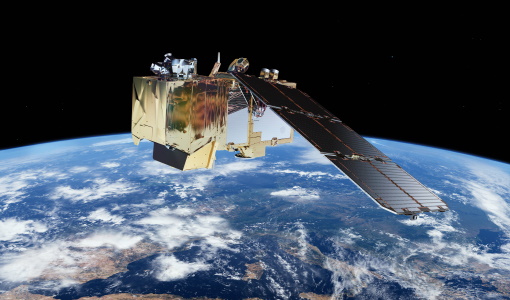
Copernicus Sentinel-2
The Copernicus Sentinel-2 mission comprises a constellation of two polar-orbiting satellites placed in the same sun-synchronous orbit, phased at 180° to each other.
News - Success Stories

Charter on major disasters celebrates 20 years of operations
The International Charter Space and Major Disasters is now 20 years old.