- All Categories (34)
- Data (3)
- News (10)
- Missions (3)
- Events (2)
- Tools (4)
- Documents (12)
News - General News
International collaboration: Summarising ESA’s Third Party Missions
ESA’s Third Party Missions programme consists of more than 50 missions from around the world. Learn more about the Third Party Missions in this video.
Document - Data Access Information

ESA-archive-third-party-mission-collections.pdf
Discover the ESA archive data collections offered for the Third Party Missions programme.
Tools - Catalogues

FedEO
FedEO is a data catalogue that provides a unique entry point to a number of scientific catalogues and services for, but not limited to, European and Canadian missions.
Tools - Catalogues

ESA PDGS DataCube
ESA's DataCube is a data catalogue that enables multi-temporal and pixel-based access to a subset of data available from ESA
Tools - Catalogues

EO CAT
EO CAT is a data catalogue, offering a Next Generation Earth Observation system designed to manage end-user Earth Observation services.
News - Infographics

A summary of ESA Third Party Mission collections
A new summary is available, showcasing the ESA archives for Third Party Mission collections.
Document - General Reference

Heritage Space Programme interactive brochure
Learn about ESA's Heritage Space Programme in this interactive brochure.
Document - General Reference

Heritage Missions brochure
This brochure describes ESA's Heritage Space Programme and includes infographics describing some of the missions in the programme.
News - Infographics

Timeline to over 40 years of historical satellite missions
ESA's Heritage Space Programme preserves historical data from over 40 years of Earth observation missions.
Event - Workshop

Coastal and Marine Applications of SAR Workshop 2003
The second in the Coastal and Marine Applications of SAR Workshop series covered a range of topics on applications of synthetic aperture radar (SAR) in coastal and marine environments.
News - Data Release news
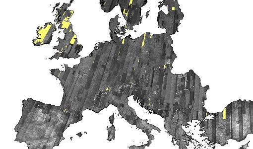
IRS-1C/1D European coverages dataset available to users
Three European coverages (including Turkey) made by the Indian Remote Sensing Satellite IRS-1C and IRS-1D from the PAN sensor are now available.
News - General News

ESA and GAF AG continue to offer free-of-charge access to Third Party Mission data
In January 2021, ESA and GAF AG extended their agreement under ESA’s Third Party Missions programme regarding the provision of IRS data and DSMs until the end of 2021.
Document - Technical Note

Indian-Data-Terms-Of-Applicability.pdf
This document contains the Terms of Applicability and the Terms and Conditions for accessing the third party mission data from Indian data sources.
News - Success Stories

A stroll through Heritage Missions
At ESA's Earth Observation centre—ESRIN—in Frascati, Italy, there is a place where one can walk back in time, to better understand the history and importance of Heritage Missions and their data.
Tools - Analysis

ESA PDGS Jupyter Notebook
A series of Jupyter Notebooks are available, in order to understand how to exploit the API that provides the data access service for different types of datasets included in the ESA PDGS datacube.
News - General News

ESA's new DataCube service is now available
ESA is pleased to announce the deployment of a new service, called ESA PDGS-DataCube, enabling multi-temporal and pixel-based access to a subset of the data available in the European Space Agency dissemination services.
News - General News

ESA’s Earth Observation Catalogue and its services
EO-CAT is the EO Catalogue tool allowing users to search ESA and Third Party Mission collections.
Document - User Guide

TPM-L-OADS-dissemination-service-User-Manual.pdf
This guide describes the Third Party Missions Dissemination System.
Data - EO Sign In Authentication (Open)
SeaSat ESA archive
This collection gives access to the complete SEASAT dataset acquired by ESA and mainly covers Europe. The dataset comprises some of the first ever SAR data recorded for scientific purposes, reprocessed with the most recent processor. The Level-1 products are available as: SAR Precision Image [SEA_PRI_1P] SAR Single Look Complex Image [SEA_SLC_1P] SAR Ellipsoid Geocoded Precision Image [SEA_GEC_1P] Spatial coverage: Check the spatial coverage of the collection on a map available on the Third Party Missions Dissemination Service.
Data - Project Proposal (Restrained)
IRS-1C/1D Full archive
The following products are available: PAN: Panchromatic, resolution 5 m, Coverage 70 km x 70 km, radiometrically and ortho (DN) corrected, LISS-III: Multi-spectral, resolution 25 m, Coverage 140 km x 140 km, radiometrically and ortho (DN) corrected (ortho delivered without Band 5) WiFS: Multi-spectral, resolution 180 m, Coverage 800 km x 800 km, radiometrically and ortho (DN) corrected. Sensor Type Resolution (m) Coverage (km x km) System or radiometrically corrected Ortho corrected (DN) Global archive PAN Panchromatic 5 70 x 70 X X 1996 – 2007 (IRS-1C) 1998 – 2009 (IRS-1D) LISS-III Multi-spectral 25 140 x 140 X X (without band 5) WiFS Multi-spectral 180 800 km x 800 km X X Note: Whether system corrected or radiometrically corrected products are available depends on sensor and processing centre For PAN and LISS-III ortho corrected: If unavailable, user has to supply ground control information and DEM in suitable quality For WiFS ortho corrected: service based on in house available ground control information and DEM.