- All Categories (37)
- Data (11)
- News (12)
- Missions (4)
- Events (4)
- Tools (1)
- Campaigns (5)
News - Success Stories

How scientists are unlocking the potential of SAOCOM
A team of scientists has drawn on SAOCOM data to measure the heights of forests in Argentina, marking the first time that tree canopies have been mapped using the two-satellite constellation.
News - Infographics
Showcasing the NovaSAR-1 radar satellite
Learn about the NovaSAR-1 mission in our new infographic.
News - Announcement of Opportunity updates
ESA encourages S-band applications with NovaSAR-1 Announcement of Opportunity
ESA is offering possibilities to develop new applications in the S-band microwave frequency range, with a new Announcement of Opportunity for NovaSAR-1 data, via ESA’s Third Party Mission programme.
Mission - Third Party Missions
NovaSAR-1
Launched on 16 September 2018, NovaSAR-1 features an S-band synthetic aperture radar (SAR) instrument offering a variety of modes with different resolutions and swath widths.
Data - Announcement of Opportunity (Restrained)
Announcement of Opportunity for NovaSAR-1
ESA is launching an Announcement of Opportunity for the international scientific community to access data from the NovaSAR-1 mission for science and EO-based applications development.
News - Thematic area articles
Tracking the world’s forests from space
As human activities continue to threaten the planet’s forests, data delivered by satellites are boosting global efforts to conserve these crucial natural resources.
News - Spotlight on EO community
An overview of the Biomass mission
In this video, Klaus Scipal - Biomass and SMOS Mission Manager - talks about ESA's upcoming Biomass mission.
News - Data Release news
New BorealScat campaign dataset released
A new dataset has been released for the BorealScat campaign, which took place between 2017 and 2021 in Sweden.
News - Infographics

An overview of ESA's Biomass Earth Explorer satellite
Learn about ESA's upcoming Biomass mission, which is dedicated to gathering information about the global distribution of forest biomass, in our latest infographic.
News - Thematic area articles

How satellite data help to shape society
Data from ESA’s Earth observation archives are improving understanding of the interactions between human activities and the environment, helping to power green economic development and boosting prosperity in Europe and beyond.
Event - Training

EO Summer School 4
ESA's series of summer schools, on Monitoring of the Earth System, aims to promote the exploitation of Earth observation data.
News - Infographics
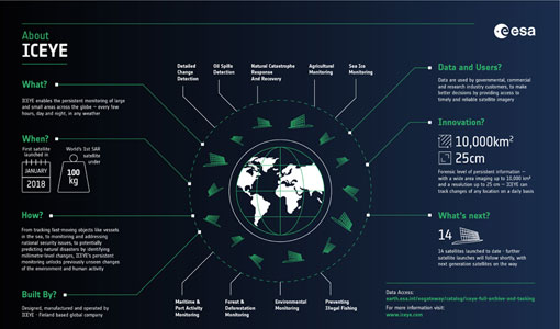
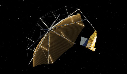
ICEYE – A persistent monitoring SAR constellation
Learn more about the ICEYE mission, a constellation of SAR satellites and part of ESA's Third Party Missions programme, in our latest infographic.
News - Success Stories
ESA's open source computing project for the Biomass mission goes live
The Biomass Product Algorithm Laboratory (BioPAL) is an open-source scientific computing project, which supports the development of ESA’s Biomass mission algorithms coded in Python.
Mission - Third Party Missions

COSMO-SkyMed Second Generation
COSMO-SkyMed Second Generation is at the forefront of radar technology, will ensure improvements and guarantee continuity with the First Generation CSK satellites, preserving the high quality and the highest precision features, both required for the interferometric activities.
News - Success Stories

Drone-based Laser Scanning of Tropical Forests for Biomass Cal/Val
ESA’s upcoming mission Biomass will deliver valuable P-band SAR data aimed at forest aboveground biomass (AGB) estimation across the humid tropics.
Data - Project Proposal (Restrained)

SPOT-6 to 7 full archive and tasking
The SPOT 6 and 7 satellites ensure data continuity with the no longer operational SPOT 5 satellite and provide an archive of very high resolution optical acquisition as well as the possibility to task the satellites for new acquisitions. Following the completion of the SPOT 7 mission in March 2023, new acquisition tasking is only available for the SPOT 6 satellite. The ortho-products are automatically generated by the SPOT 6 and 7 ground segment, based on SRTM database or Reference3D when available. The projection available for SPOT 6 and 7 ortho-products is UTM, datum WGS84. Bands combinations: Pansharpened: colour image at 1.5 m resolution Bundle: 1.5 m panchromatic image and 6 m multispectral image. Geometric processing levels: Primary: The Primary product is the processing level closest to the natural image acquired by the sensor. This product restores perfect collection conditions: the sensor is placed in rectilinear geometry, and the image is clear of all radiometric distortion. Standard Ortho: The Ortho product is a georeferenced image in Earth geometry, corrected from acquisition and terrain off-nadir effects. Tailored ortho: Aside from the Standard Ortho product, when different specifications are needed, a custom orthorectification, with a more precise 3D model provided by the client or acquired for the purpose, can be provided on demand. As per ESA policy, very high-resolution imagery of conflict areas cannot be provided.
Tools - Other

Forestry TEP
The Forestry Thematic Exploitation Platform (TEP) enables users in the forestry sector to access satellite data based processing services and tools for generating value-added forest information products.
Data - Announcement of Opportunity (Restrained)

Announcement of Opportunity for NoR
ESA invites submissions for the Network of Resources (NoR) call, which aims to support research, development and pre-commercial users to innovate their working practices, moving from a data download paradigm towards a 'bring the user to the data' paradigm.
Event - Training

10th Advanced Training Course on Land Remote Sensing EO and AI for Forestry
This ESA course was dedicated to training the next generation of EO scientists and experts working in forestry domain to exploit data from EO missions and use AI for science and applications development.
News - General News

ICEYE data available for assessment
The SAR user community is invited to participate to the call to assess the suitability of the ICEYE constellation, for science and EO-based applications.