- News
- Satellite data predicts lower ...
Satellite data predicts lower wheat crop yield
07 Sep 2022
In a market pressed with short supply of grain the dry spring weather of 2022 was devastating for European wheat production, according to a new drought monitor that draws on data from ESA’s SMOS Earth observation mission.
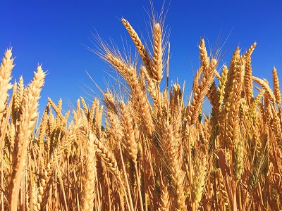
A critical stage in the growth of wheat is the jointing stage - when the growth moves above the soil surface. Therefore, any soil moisture stress in the spring can negatively impact crop health and cause crop loss.
Satellite data has proven instrumental in tracking droughts and predicting wheat crop yields.
The Soil Moisture and Ocean Salinity (SMOS) mission is one such satellite, a member of ESA’s family of research missions - the Earth Explorers - which are focused on investigating the impact anthropogenic activities have on Earth’s systems.
Microwave L-band measurements from SMOS show global observations of variability in soil moisture, which provide long-term datasets for a new European drought monitor developed by isardSAT and Lobelia in the framework of the EU’s H2020 ACCWA project.
A methodology developed by the Spanish based team showed strong correlation between soil moisture drought indices and scarcity in crop yield production – results were presented recently at ESA’s Living Planet Symposium in Bonn [1].
During March, extreme drought was measured by the ACCWA drought monitor in the Ebro basin, a wheat growing region in Catalonia, northern Spain.
Maria José Escorihuela, Principal Investigator for the ACCWA project at isardSAT, says: “Current drought observation warning systems offer maps of combined drought indices, derived from different data sources – meteorological measurements, satellite data and models. However, our work has shown that the anomaly of soil moisture in March is a strong indicator for crop yield at the end of the season.
“Our soil moisture-based drought monitor has a good spatial resolution and can even depict streams.”
The SMOS satellite – which launched November 2009 – hosts the microwave imaging radiometer with aperture synthesis (MIRAS) instrument. Soil moisture affects the microwave radiation emissivity of soil, so MIRAS tracks variations in soil moisture by monitoring the L-band microwave radiation emitted over land.
Generated from data collected by the MIRAS, the image below – which captures Ebro basin – shows a drought index for March 2022 with extreme drought in the cereal region.
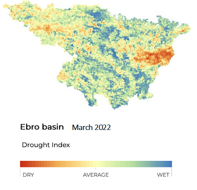
The drought index is based on SMOS Level 2 soil moisture products downscaled to a resolution of one kilometre [2].
Escorihuela adds, “The availability of a SMOS soil moisture long time series allows us to estimate the so-called “climate normality”. The drought monitor is based on soil moisture anomaly – the difference in soil moisture and the average over the 12 + year lifetime of the SMOS mission.
“Strictly speaking, when talking about anomalies in meteorology, you usually use a time period of 30 years, but we have seen it corresponds very well with a series of only 11 years.”
The monitor is updated monthly, but in collaboration with the Observatori de l’Ebre, the team also deliver a weekly drought bulletin zoomed in over the part of the Ebro river basin region, where traditional rain irrigated vineyards are cultivated.
Due to climate change projections, the vineyards are transitioning to irrigated wine production and rely on weekly information to support this transition.
As European markets strive to offset food insecurity, the timing of Europe’s dry spring couldn’t have been worse. For the Catalonian region alone, tons of cereals have been lost in this summer’s harvest.
Estimates for accumulated damages on the region’s wheat harvest are above nine million euro, due to the adversely dry spring. The results from the drought monitor are valuable for multiple sectors, facilitating the anticipation of adaption measures.
As summer heatwaves intensified in Spain, extremely dry soil moisture conditions emerged in the western part of the Ebro basin. The drought monitor captured this drought, highlighting water reservoirs at risk.

Whether it be helping predict wheat and wine production, or simply monitoring drought, the soil moisture data products from SMOS are a key tool in unravelling the impacts of our current climate crisis.
References
- Khlif et al, “Potential of remote sensing to study the influence of drought on cereal yields in semi-arid regions.” ESA Living Planet Symposium 2022.
- Merlin et al, (2013) “Self-calibrated evaporation-based disaggregation of SMOS soil moisture: An evaluation study at 3 km and 100 m resolution in Catalunya, Spain.” Remote sensing of environment. 130, 25-38.