- News
- ERS Heritage Data allow for 30...
ERS Heritage Data allow for 30 years of science
19 Jul 2021
At their time of launch thirty years ago, the two ERS satellites were the most sophisticated Earth observation spacecraft ever developed and launched by Europe. These highly successful ESA satellites collected a wealth of valuable data on Earth's land surfaces, and oceans and polar caps, while being called upon to monitor natural disasters such as severe flooding or earthquakes, in remote parts of the world—making a difference to Science.
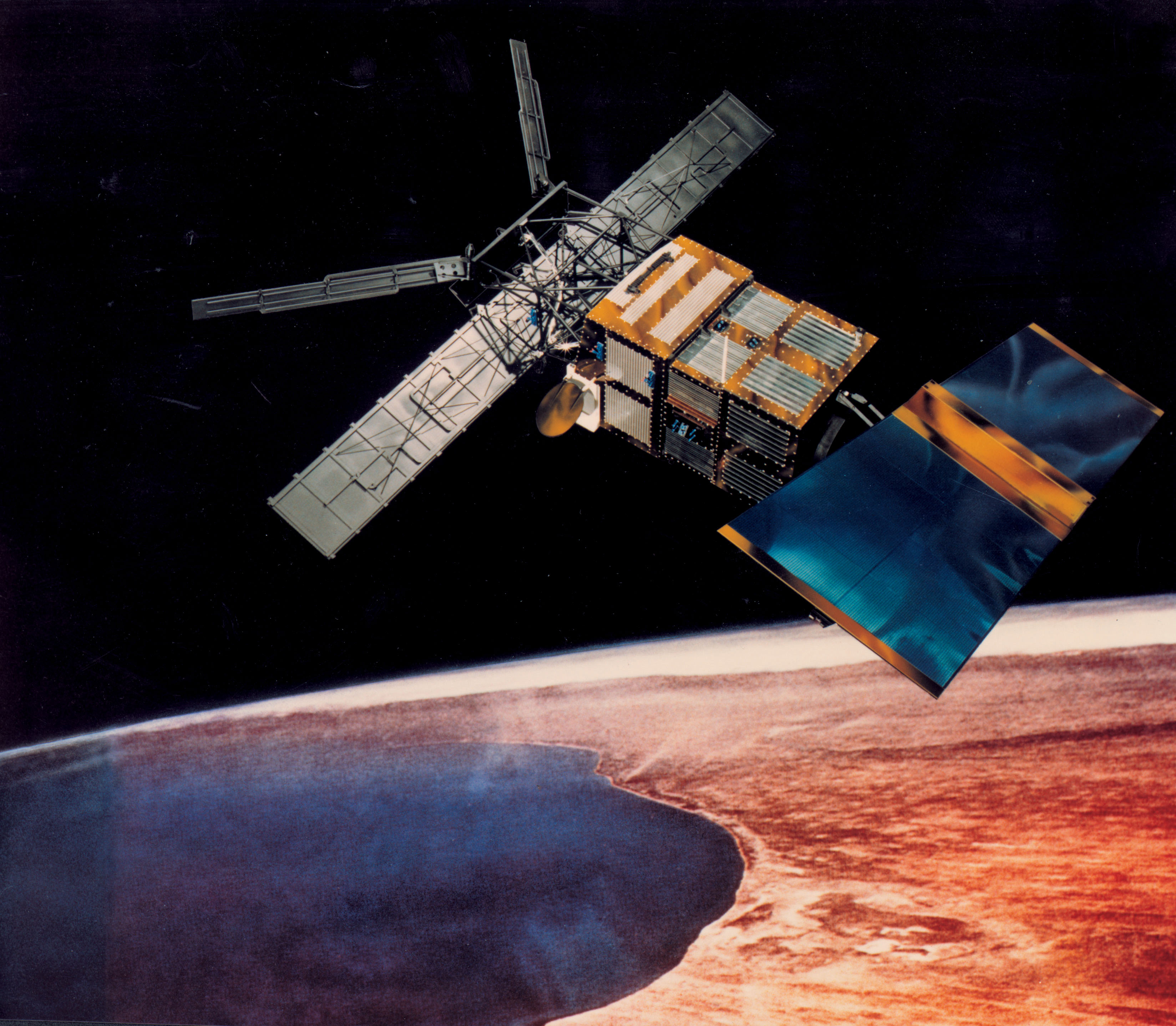
Launched on 17 July 1991, the European Remote Sensing satellite, ERS-1, carried a comprehensive payload including an imaging synthetic aperture radar, a radar altimeter and other powerful instruments to measure ocean surface temperature and winds at sea. It was ESA’s first dedicated Earth observation mission.
ERS-2, launched on 21 April 1995, had an additional sensor for atmospheric ozone research, the Global Ozone Monitoring Experiment (GOME). Both ERS satellites were built with a core payload of two specialised radars and an infrared imaging sensor. The two were designed as identical twins, with the exception of the GOME instrument.
Shortly after the launch of ERS-2, ESA decided to link the two satellites in the first ‘tandem’ mission, which lasted for nine months. During this time, the increased frequency and level of data available to scientists offered a unique opportunity to observe changes over a very short time span, as both satellites observed the same location on Earth only 24 hours apart, and to generate accurate digital elevation models (DEMs) on a worldwide scale.
ERS-2 was further operated in tandem with ESA's subsequent Earth observation mission—Envisat—in 2007, 2008 and 2009. The success of the first tandem operation also paved the way for future tandem operations and missions, such as Germany's TanDEM-X and TerraSAR-X.
ERS-1 and ERS-2 had only been designed to operate for three years, but both actually far surpassed their planned lifetime—ERS-1 satellite was operational for nine years, until 10 March 2000, when the satellite experienced an on board attitude control system failure, while ERS-2 was still functioning nominally after 16 years of operations in 2011. The satellite was, however, running low on fuel, so ERS-2's orbit altitude was lowered from 785 km to about 573 km to reduce risks of collision with other spacecrafts.
The ERS data acquired for some 20 years still provide today a wealth of information about our Planet and are preserved, maintained accessible and continuously improved to build long time series with newer missions.
For more than 40 years, ESA has acquired data from over 45 Earth observation missions (including Third Party missions launched and operated by international partner agencies). Preservation, accessibility and quality improvement of heritage data acquired from missions that concluded operations, including ERS, and access to relevant documentation and software are ensured today through a dedicated programme named Heritage Space (LTDP), created in 2008 as part of ESA’s Mandatory Activities.
But just how did ERS make a difference?
The following are just some examples of the many benefits that ERS data have brought to Science and Research over the years.
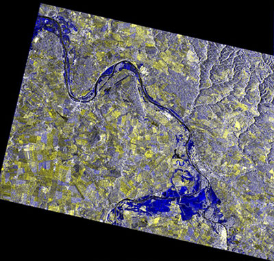
Floods: ERS-2 was often used in the context of the International Charter on Space and Major Disasters, as in the cases of floods.
Terrain deformation measurement through SAR Interferometry: Data from ERS’s synthetic aperture radar (SAR) helped, among many other applications, in monitoring earthquakes and volcanic eruptions events, through terrain deformations measurements.
Ocean surface wind fields: ERS carried a C-band scatterometer, capable of measuring ocean surface wind fields even in the fiercest of weathers.
Sea and Land Surface Temperature: ERS Along Track Scanning Radiometer (ATSR) was used to track water and land surface temperatures, which are crucial for climate change monitoring.

Land Cover classification and changes detection: ERS SAR data allowed to generate large scale land cover maps featuring seasonal variation of vegetation in support to forestry, agriculture monitoring and planning, and urban mapping applications.
Subsidence: With advances in the methods of interferometry, subsidence of entire countries were easily mapped using ERS SAR data.
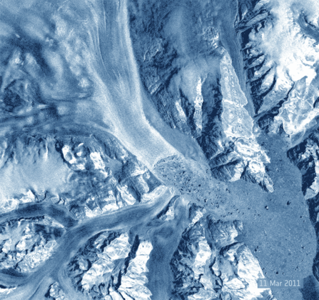
Ice Monitoring: ERS has allowed to track changes in arctic sea-ice extent and to track calving fronts in Greenland’s largest ice streams.
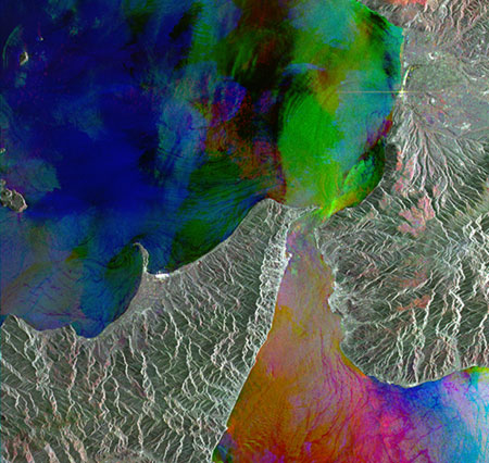
El Nino: The combination of ERS-2's ATSR and Radar Altimeter data allowed to map temperature and height abnormalities arising from the 1997 El Nino event in the Pacific, thus bringing further understanding to ocean warming factors and consequent effects on global climate.
Read more about the ERS programme's 30 years of achievements in this related article.
Furthermore, ERS enabled a concrete cooperation on applications and science with the USA, China, Japan, India, Russia, Australia, South Africa and others, and with International and European organisations (ECMWF, FAO, UNESCO, UNDCP, REMPEC and UNOOSA), as well as the worldwide scientific community and more.
The success of ERS also paved the way for further Earth Observation missions such as Envisat and today's Copernicus Sentinel family of satellites, which were built evolving ESA’s heritage systems, developed and launched onboard ERS-1 and ERS-2.
Together, these three generations of missions provide a record of 30 years of continuous observations of our Planet, supplying valuable long-term datasets for research and operational applications benefitting from long time-series analysis.
Mirko Albani, Heritage Missions Manager at ESA, affirms, “ERS had an enlightening impact on Earth science research and operational applications and marked a fundamental milestone for Earth Observation activities at ESA, paving the way for the development, launch and operation of a long series of following missions.
“ERS Heritage data are still widely used today by scientists and researchers, as they provide a unique possibility to look back in time and better understand how our planet works, to learn more about how it is changing, also due to human activities, and what the impact on our lives can be”, concludes Mirko.
Today, ESA Heritage Missions Data holdings are preserved, managed and curated in the frame of the Heritage Space Programme, and made accessible with state of art technologies and modern tools like Mobile Apps (iOS and Android) or Data Cubes, offering advanced capabilities for end users.