- News
- ERS' Contribution to Altimetry
ERS' Contribution to Altimetry
11 Oct 2021
Satellite radar altimetry missions have transformed the way we see Earth and its oceans. Using the ranging capability of radars, they measure the surface topography profile along a satellite’s track. They provide precise measurements of a satellite's height above the ocean, by measuring the time interval between the transmission and reception of very short electromagnetic pulses.
Precise altimetry measurements give us the ability to observe essential climate change parameters such as time-varying sea-surface height, the lateral extent of sea ice, the altitude of large icebergs above sea level and the topography of land, ice sheets and the sea floor. They can also provide data for mapping sea-surface wind speeds and significant wave heights.
The first three altimetry missions were launched by the US. NASA’s Geos-3 was the first satellite to carry a radar altimeter and operated from 1975 to 1978. In 1978, NASA launched the SeaSat mission intended as a proof of concept for the viability of using synthetic aperture radars (SAR) to study our planet from space.
In its 110-day lifetime, SeaSat collected more information about the oceans than had been acquired in the previous 100 years of shipboard research, effectively proving that SAR altimetry was a highly accurate method for Earth Observation.
The US Navy’s GEOSAT satellite that operated between 1985 and 1989, provided the first high-quality altimetric dataset. It was the first mission to employ an exact repeat orbit, which meant the signal passed over the exact same areas every 17 days, allowing for better comparison of data to extract sea surface variability.
The launch of ERS

On 17 July 1991, ESA launched its first Earth Observation-dedicated satellite, the European Remote-Sensing Satellite 1 (ERS-1). It was followed by ERS-2 on 21 April 1995. Both ERS satellites’ payloads included an imaging synthetic aperture radar and a radar altimeter and aimed to study the complexities of the atmosphere, land, oceans and polar caps.
Shortly after the launch of ERS-2, the two satellites were linked in tandem for nine months, providing a unique opportunity for scientists to observe changes with an accuracy in the millimetre range over a very short time span, as both satellites passed over the same location within 24 hours of each other. During this time, the new technique of radar interferometry was also tested.

Interferograms are created through the superimposition of images taken of the same areas twice or multiple times, with the two satellites at different time intervals. They are used to create digital terrain models with a height resolution of a few metres.
ERS altimetry data leads the way for environmental research
The ERS satellites had an altimetric mission objective: to map global ocean wave heights, roughness, ocean circulation and associated transfers of energy, including ocean–atmosphere interactions. However, the application of its altimetry data was quickly expanded and the ERS mission became a pioneer of environmental research from space. Radar interferometry in particular revolutionised Earth sciences through its ability to measure digital terrain models, the speed of the movement of glaciers and the ground motion of earthquakes.
Thanks to their long life, the ERS satellites have also contributed to some of the world’s longest data series for many climate variables, such as polar ice cover, sea level rise and ocean surface temperature trends. They were also crucial to further our understanding of the cryosphere, by expanding the coverage of polar areas.
"ERS-1 launched a data revolution and transformation in observing and understanding the ice sheets covering Antarctica and Greenland,” explains Jonathan Bamber, Professor of Physical Geography at the University of Bristol.
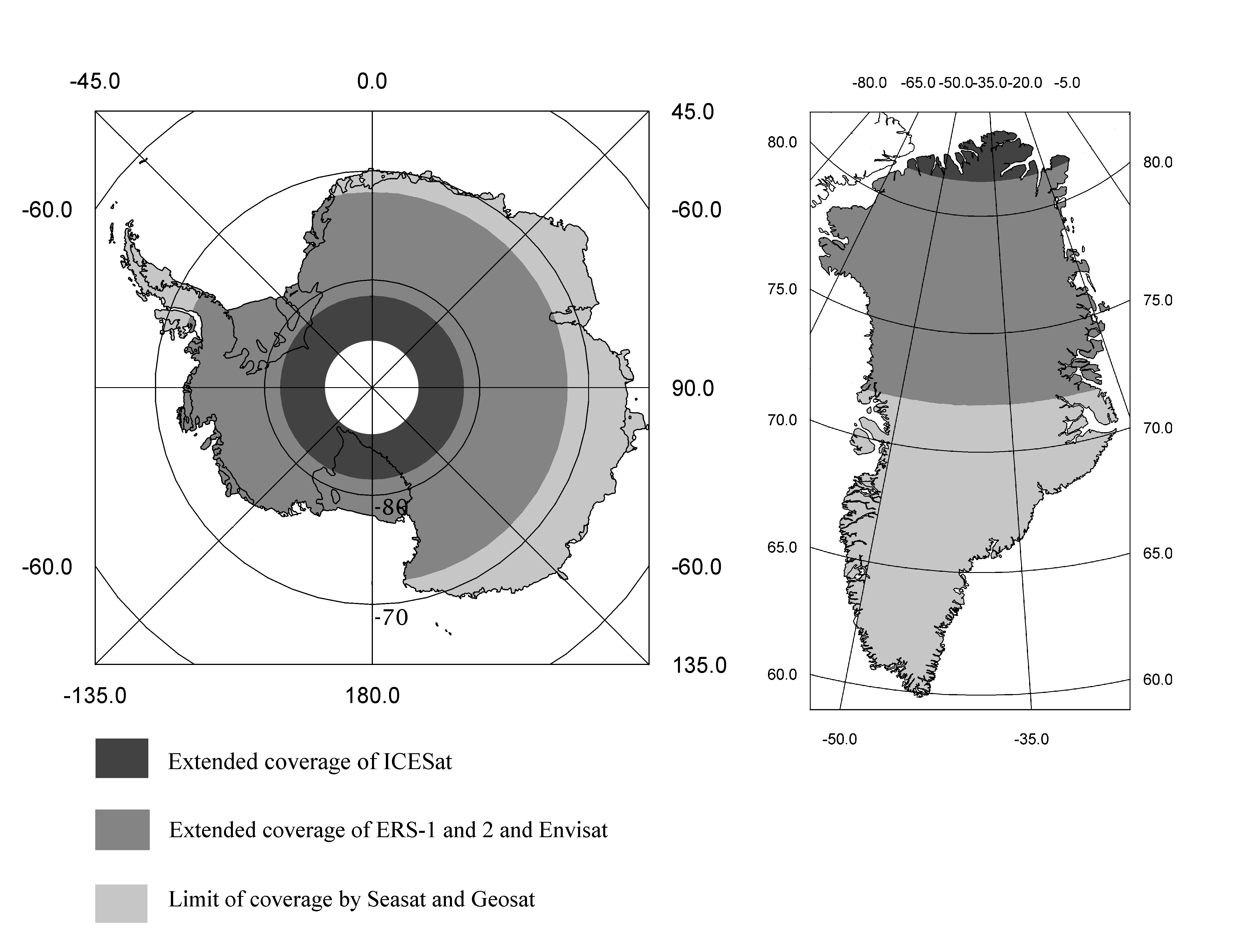
“The radar altimeter on board ERS-1 was the first to provide almost complete coverage over Greenland and about 80% of Antarctica. For the first time, we could derive accurate and extensive elevations and elevation change over the ice sheets."
ERS-1’s radar altimeter also contributed to geodetic research, ice and sea-ice studies and improvements in Digital Elevation Models (DEMs). At the request of the scientific community, ERS-1 was flown in a very dense orbit between April 1994 to March 1995, making it possible to map the mean sea surface and derive the marine geoid and seafloor bathymetry at unprecedented resolution and accuracy. The ERS‑1 geodetic phase data acquired over land were used to correct existing DEMs and led to the release of a new global and accurate DEM called Altimetry Corrected Elevation (ACE).
“After 30 years, we are still exploiting and benefiting from the ERS-1 altimeter data in a multi-mission context, building Fundamental Data Record and Thematic Data Products to support new science," says Pierre Féménias, ESA Altimetry Data Quality Manager.
“ERS-1 was the first ESA Altimeter mission in Ku band and the first in a long successful series. We can be proud today of this success which paved the way to so many applications and science.”
Beyond ERS
ESA continued its contribution to altimetry through the launch of Earth Explorer mission, CryoSat on 8 April 2010. Its primary instrument is the Synthetic Aperture Interferometric Radar Altimeter (SIRAL), which was based on heritage from existing instruments including ERS’ and was designed to measure ice-sheet elevation and sea-ice freeboard.
CryoSat determines the thickness of floating sea ice by measuring the freeboard of ice floes, the height by which the ice extends above the water surface. This technique was demonstrated by the ERS-1 radar altimeter despite its relatively low spatial resolution of about 5 km. CryoSat’s SIRAL instrument improved on it, achieving a 250 m spatial resolution in the along-track direction.
Another important ESA mission contributing to altimetry is Copernicus Sentinel-3, launched on 16 February 2016. Its primary aim is to measure sea surface topography, sea and land surface temperature, and ocean and land surface colour with high accuracy and reliability to support ocean forecasting systems, environmental monitoring and climate monitoring.
Among its innovative instrument package, there is a dual-frequency (Ku and C-band) advanced Synthetic Aperture Radar Altimeter (SRAL) built on heritage directly from other altimetry ESA missions such as ERS and CryoSat. SRAL provides accurate topography measurements over sea-ice, ice sheets, rivers and lakes.
“ERS had an enlightening impact on Earth science research and operational applications and marked a fundamental milestone for Earth Observation activities at ESA,” says Mirko Albani, Heritage Missions Manager at ESA.
“ERS Heritage data are still widely used today by scientists and researchers, as they provide a unique possibility to look back in time and better understand how our planet works, to learn more about how it is changing, also due to human activities, and what the impact on our lives can be.”