- News
- A Guide to Aeolus Range Bin Se...
A Guide to Aeolus Range Bin Settings
07 Sep 2020
Launched on 22 August 2018, Aeolus is the first satellite mission to acquire profiles of Earth's wind on a global scale. After almost two years in space, its near-real time observations have been assimilated into the Numerical Weather Prediction (NWP) models of several European meteorological services, like ECMWF, Météo-France and DWD, and have proven crucial when the grounding of airplanes during the COVID-19 pandemic led to a sharp decrease in meteorological observations.
By providing information on aerosol and clouds from the ground up to the lower stratosphere, Aeolus data are also an essential part of furthering our understanding of tropical dynamics and processes relevant to climate variability.
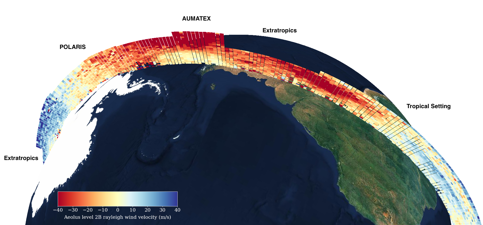
Aeolus flies in a sun-synchronous orbit along meridional lines at about 320 km altitude. Profiles of the horizontal wind speed as well as information on aerosol and clouds are measured along these lines as vertical intersections through the atmosphere. The ALADIN instrument measures winds in defined distances between the surface and 30 km altitude, from where it receives the backscattered signal. Twenty four vertical range bins divide the atmosphere into boxes from the ground up to 25 km, sometimes going as high as 30 km. The distribution of these 24 range bins is defined through dedicated Range Bin Settings (RBS).
Current Range Bin Settings
Multiple Aeolus Range Bin Settings are active at the same time. Current settings can be updated, and new settings introduced. At the moment, there are six active range bin settings: the tropical, polar (POLARIS), extratropical and Quasi-Biennial Oscillation (QBO2020) settings, which cover entire belts and two smaller local boxes, one over the Eastern Mediterranean (MARS) and one over Chile (AUMATEX).
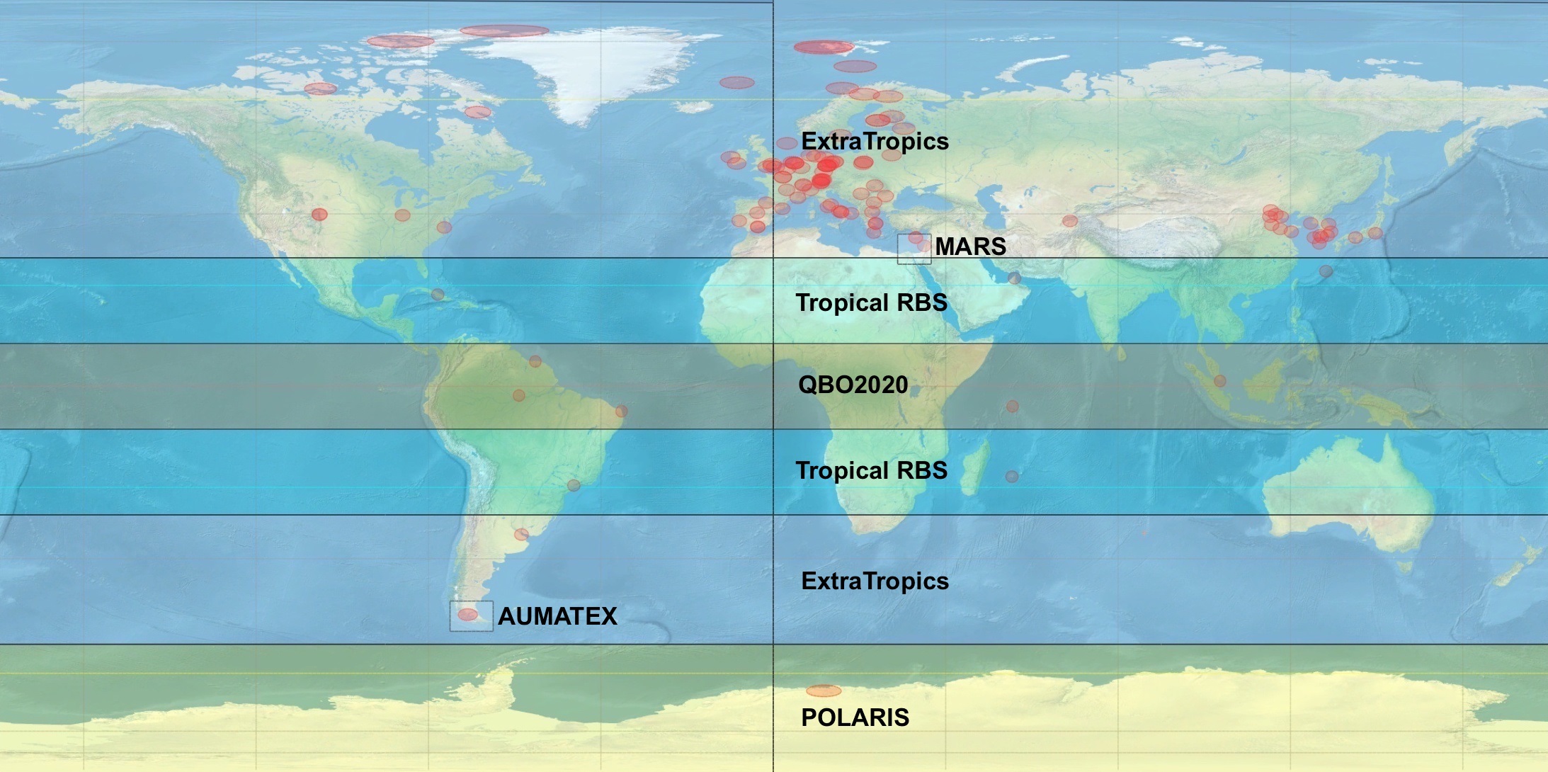
The main reason to change or add range bin settings is to address particular scientific and Aeolus mission objectives. Some of the settings are changed seasonally, while others are long term and are meant to support data assimilation by NWP centres. In the case of dedicated science objectives, validation campaigns or specific events such as volcanic eruptions or smoke, a limited spatial box can be defined.
New range settings are usually proposed by NWP centres, Aeolus calibration and validation teams, the Aeolus Data, Innovation, and Science Cluster (DISC) or the Aeolus Science Advisory Group (SAG). The proposals are first discussed in the Range Bin Settings Working Group, consisting of Aeolus internal, data quality, NWP and science experts, before they are presented to the Aeolus mission manager who takes a final decision after conferring with an advisory board.
Tropical Setting
The tropical setting addresses one of the core objectives of the Aeolus mission: the improvement of NWP. The tropics are where Aeolus data have been shown to have one of the highest impact on short-range forecasts by NWP centres.
The setting covers a wide region from about 30 degrees south to 30 degrees north, reaching just over 20 km in altitude. A request from the science community to sample the region between 12 and 15 km at a higher resolution of 750 m to detect gravity waves was later added to it. The reason behind the request was the need to accurately measure gravity waves and vertical fluxes that are usually hard to detect as they occur periodically on very small timescales and can create uncertainties in climate models.
Polar Setting
POLARIS, the Aeolus polar setting is updated on a seasonal basis to measure the winter period in the polar regions with a dedicated configuration. During summer in the Northern Hemisphere, POLARIS is active in the South Pole region, covering an area from 60 degrees South to the South Pole. The main purpose of this setting is to measure polar stratospheric clouds (PSCs) and strong winds triggered by the polar vortex in very high altitudes. Both phenomena occur only during polar winter.
The stratospheric polar vortex acts like a barrier of very strong winds that isolates the polar regions from everything outside them. In winter, there is no light and as it gets colder, the vortex gets stronger and the winds reach very high altitudes. PSCs only form at very low temperatures and play a crucial role in the formation of the polar ozone holes. For this reason, POLARIS goes up to 25 km to measure them.
This setting was primarily driven by scientific and NWP goals. A better understanding of the seasonal phenomena occurring in the polar vortex can help scientists address key climate change questions, such as the increase in polar stratospheric temperatures and the chemical processes that lead to ozone depletion.
Due to their remote location and harsh conditions, very little data from the arctic regions are available for assimilation into NWP models. Any measurements from these areas are therefore useful not only for scientific objectives and studies, but also for weather prediction. The change of POLARIS from one Pole to the other is made with the support of ECMWF that runs the forecast for the polar vortex.
Extratropical Setting
The extratropical setting covers all areas outside the tropics and the poles. The measurements are lower than at the tropics, reaching a maximum altitude of around 17.5 km. The altitudes between 5 – 10 km, which mark the jet stream area, are sampled at a higher resolution of 500 m. In the European region, the area where warm air masses from the south meet the colder air masses of the north create this area of very strong winds called the jet stream.
NWP impact experiments at ECMWF showed that the highest impact of Aeolus data in the extratropics come from altitudes of around 8 km, with the impact gradually diminishing at higher altitudes. Most Mie winds in the extratropics are observed in the jet stream area and from boundary layer clouds. The extratropical setting thus optimises vertical resolution in the lower troposphere, where clouds usually produce high noise.
The MARS Box
The so-called Mediterranean range bin setting (MARS) is an aerosol-optimised range resolution operational for Aeolus in the Eastern Mediterranean since September 2019. It covers a box of roughly 7x7 degrees: between 28 and 35 degrees north and 28 and 36 degrees east. Measurements, focusing on aerosol and clouds, are performed with a very high vertical resolution of 250 m in the lower troposphere from close to the ground up to only 5 km.
MARS supports the aerosol studies of dedicated Aeolus calibration and validation teams in the East Mediterranean, measuring aerosol distributions of various kinds of aerosols (pollution from the Middle East, Saharan dust, Arabian dust, biomass burning aerosol, marine aerosol etc.) in order to address scientific questions on the influence of aerosol concentrations on radiative models, health and aerosol composition.
The MARS box is aimed at long term measurements, to understand how well Aeolus measures aerosol layers and how aerosol distribution and layer thickness vary during seasonal changes. The Aeolus measurements in the MARS box also provide a unique dataset for the product development teams of the EarthCARE mission.
Australian Smoke Box
In the wake of the wildfires that devastated Australia earlier this year, the ground-based Aeolus validation station in Punta Arenas, Chile, detected smoke in very high atmospheric layers. The corresponding validation team proposed a new local range bin setting, called AUMATEX, that would measure the very high altitudes of that region to assess the Aeolus measurements performance for such cases.
AUMATEX became Aeolus's highest range bin setting, going above the troposphere, up over 28 km. For the first time aerosol, particles and Mie winds were measured with Aeolus at such a high altitude, showing that Aeolus can continue to provide accurate measurements even at that height.
Quasi-Biennial Oscillation Setting
The latest range bin setting, QBO2020, activated on 17 June 2020, supports the investigation of the Quasi-Biennial Oscillation (QBO) over the Tropical belt. Aeolus is uniquely equipped to monitor a significant disruption to the QBO that has been steadily intensifying since late 2019. The disruption is characterised by a thin easterly layer developing in the lower stratosphere coupled with an overlying westerly jet moving gradually upwards, countering the expected downward propagation of the current easterly QBO phase.
To capture this unusual feature and track its evolution, the Aeolus range bin settings were modified to increase sampling in the tropics up to 25 km. QBO2020 is active once a week for 24 hours only.
How range bin settings help to meet mission objectives
"The Aeolus range bin settings are an essential contribution to meeting the mission's objectives," Sebastian Bley, Research Fellow at ESA working on the Aeolus mission, explains. "In close collaboration with meteorological centres, we try to optimise these settings in a way that ensures that Aeolus' global wind observations can have the highest impact on the quality of weather forecasts. We also work with validation, calibration and research teams, to offer the best Aeolus product quality and to help answer key scientific questions about atmospheric dynamics and climate processes using unique sets of Aeolus data."
Aeolus's fruitful two years in space and the quality of its data have shown that Doppler wind lidars can be successfully used on satellite missions and offer exceptional advantages. The flexibility of range bin settings also contributes to addressing pressing developments in emergency situations, such as fires or volcano eruptions, while allowing for easy changes depending on the season.