- Campaigns
- AquiferEx
AquiferEx
Overview
What was the purpose of AquiferEx?
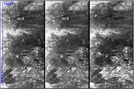
the Gabes (west part) region. HH: horizontal transmitted and
received, VV: vertical transmitted and received and XX: a
normalised value between HV and VH.
The AquiferEx Optical and Radar Campaign was in support of information product generation based on satellite data, harmonisation of satellite data acquisition performed among Aquifer and AquiferEx project partners to facilitate comparison of information retrieval possibilities for the airborne (high resolution) and space-borne cases.
Data acquired by the AquiferEx airborne campaign will be used by the Aquifer project team for the development and validation of the Aquifer science products (e.g. refined land use map). However, first evaluation of radar data with respect to soil moisture and land use/land cover classification was foreseen within this project.
What was the outcome of AquiferEx?
A data base of high resolution optical (hyperspectral) and radar (multi-frequency and polarisation) data has been acquired as a result of the AquiferEx campaign, for areas typical of semi-arid regions covering a huge variety of land use and irrigation practise. This data base is complemented by a variety of ground measurements and several satellite data acquisitions. Initial soil moisture and classification results demonstrate that high resolution radar sensors are able to provide relevant information for national authorities to help the management of water resources in arid regions, which is one of the most challenging tasks in African countries. The further use of the acquired airborne data and the synergy with satellite data will further be investigated in the frame of Aquifer and follow-on projects.
Download the AquiferEx Final Report
| Data Coverage (Year) | 2005 |
| Geographic Site | Ben Gardane, Gabes (Tunisia) |
| Field of application | Soil moisture, land use, land cover classification |
| Data size | More than 50 GB |
Digital Object Identifier: https://doi.org/10.5270/esa-afrzuwp - AQUIFEREX: "Optical and Radar Campaign"
Data
The campaign data is available online via FTPS upon submission of a data access request. An active EO Sign In account is required to submit the request.
The data can be downloaded via an FTP client (e.g., FileZilla or WinSCP) using the option "Implicit FTP over TLS".
For further information about the EO Sign In Service you can visit TellUs
Should you need support please contact EOHelp