- Campaigns
- AfriScat
AfriScat
Overview
What was the purpose of AfriScat and AfriScat Ground?
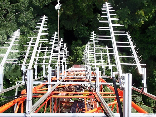
In 2015, ESA and CNES decided to support a new experiment, based on the TropiSCAT experience, to acquire long-term P-Band radar data in an African tropical forest. The site selected to host AfriScat experiment was the Ankasa Forest Conservation Area, Ghana.
The main objectives of the TropiSCAT experiment were the temporal survey of the variation of the measurements in time scales ranging from diurnal, weekly, monthly, up to 12 months of observation. The measurements which had to be tracked are in order of priority:
- The temporal coherence in HH, VV and HV polarisations, at a very short rate in the order of 15 minutes, covering daily and monthly scale,
- The backscattering coefficient at HH, VV and HV polarisations and in all time scales
- 2D vertical imaging through tomographic focusing;
- The vertical distribution of temporal coherence, as obtained by comparing tomographic data taken at different times, covering time scales of minutes, days, and months. In addition to electromagnetic scattering measurements, ancillary in-situ data are also collected on the same area.
Download reports:
| Data Coverage (Year) | Release Date | Geographic site | Field of application | Data size | LIDAR data |
| 2015 | December 2019 | Ankasa forest, Ghana | Biomass, P-Band scatterometer and Terrestrial Laser Scanning ground measurements | 71.2 GB | Available |
| 2016 | 63 GB |
Digital Object Identifier: https://doi.org/10.5270/esa-pb8t41g - AfriScat and AfriScat Ground.
Data
The campaign data is available online via FTPS upon submission of a data access request.
The data can be downloaded via an FTP client (e.g., FileZilla or WinSCP) using the option "Implicit FTP over TLS".
Submit a request for accessing AfriScat data:
- Request AfriScat data
- Request AfriScat Ground data
An active EO Sign In account is required to submit the request.
For further information about the EO Sign In Service you can visit TellUs.
Should you need support please contact EOHelp.