- TerraSAR-X and TanDEM-X
- Mission
- TerraSAR-X and TanDEM-X Overvi...
TerraSAR-X and TanDEM-X Overview
Mission Background
Both TerraSAR-X and TanDEM-X satellites are almost identical and operate in six alternate operating modes for a wide range of applications in Earth observation: ranging from Staring SpotLight mode with a resolution of up to 25 cm at a scene size of e.g. ~ 4 km x 3.7 km mainly for image intelligence applications to Wide ScanSAR providing a resolution of 40 m at a scene size of 270 km × 200 km (extendible to a scene length of 1,500 km) particularly suitable for maritime applications.
Other applications include highly precise change detection and monitoring applications, support of intelligence and security mission, disaster response and as well as mapping and generation of digital elevation models using interferometry and radargrammetry.
Thanks to different polarimetric combinations (single or dual polarisation and even full Polarimetric) and processing levels the delivered imagery can be tailored specifically to meet the requirements of the application.
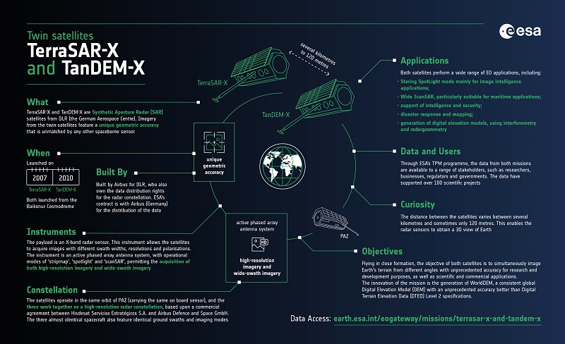
TerraSAR-X and TanDEM-X Infographic
DLR's TerraSAR-X and TanDEM-X are twin satellites flying in close formation to acquire SAR data of unique geometric accuracy. Operating together, the missions deliver data that are used to generate Digital Elevation Models of Earth.
The satellites are part of the Third Party Missions programme, in which ESA promotes the availability of the data for research and applications development.
Learn more about TerraSAR-X and TanDEM-X in this infographic:
Satellite Design
| Antenna Length | 4.8 m |
| Nominal Look Direction | Right |
| Antenna Width | 0.7 m |
| Range Bandwidth | 150 MHz / 300 MHz |
Related Links
Learn more about the TerraSAR-X and TanDEM-X missions:
- TerraSAR-X Website*
- TanDEM-X Website*
- TerraSAR-X on the eoPortal*
- TanDEM-X on the eoPortal*
- TanDEM-X on the DLR website*
- TerraSAR-X on DLR website*
- TerraSAR-X on Airbus website*
*The information provided is sourced and updated by external entities. For further details, please consult our Terms and Conditions page.