- All Categories (67190)
- Data (320)
- News (718)
- Missions (84)
- Events (206)
- Tools (21)
- Activities (77)
- Campaigns (106)
- Documents (65618)
Visualisation Tools
Find the tools you need to visualise, analyse and process the European Space Agency's Earth observation data.
Tools - Visualisation
31 Jan 2024PROBA-V Mission Exploitation Platform (MEP)
The MEP PROBA-V addresses a broad vegetation user community with the final aim to ease and increase the use of PROBA-V data by any user.
Tools - Analysis
 1 Oct 2020
ESA PDGS Jupyter Notebook
A series of Jupyter Notebooks are available, in order to understand how to exploit the API that provides the data access service for different types of datasets included in the ESA PDGS datacube.
Tools - Visualisation
14 May 2020EVDC Orbit Prediction Tool
The EVDC Orbit Prediction and Overpass Tool generates and visualises satellite's overpasses.
Tools - Analysis
 2 Mar 2020
Sentinel-3 Toolbox
The Toolbox consists of a set of visualisation, analysis and processing tools for the exploitation of OLCI and SLSTR data.
Tools - Analysis
 2 Mar 2020
Sentinel-2 Toolbox
The Toolbox consists of a rich set of visualisation, analysis and processing tools for the exploitation of optical high-resolution products including the Sentinel-2 MSI sensor.
Tools - Analysis
 2 Mar 2020
Sentinel-1 Toolbox
The Toolbox consists of: processing tools, data product readers and writers and a display and analysis application to support the archive of SAR data from ESA and 3rd party missions.
Tools - Visualisation
27 Nov 2019SMOS Global Mapping Tool
The SMOS Global Mapping Tool (GMT) is useful for plotting the SMOS data into a single global geographical map.
Tools - Analysis
7 Nov 2019VirES for Aeolus
VirES for Aeolus is a highly interactive data manipulation and retrieval interface for ESA's Aeolus mission products.
Tools - Processing
30 Sept 2019Atmospheric Toolbox
The Atmospheric Toolbox (previously known as BEAT) is a collection of executable tools and API, developed to facilitate the utilisation, viewing and processing of e.g. GOMOS, MIPAS, SCIAMACHY and GOME data.
Tools - Processing
 26 Sept 2019
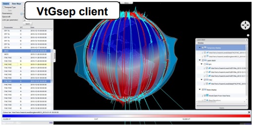
GSEP
GSEP (GOCE-Swarm Exploration Platform) is an online client tool designed to select GOCE and Swarm products, display them on a virtual globe and disseminate views of them.
Tools - Visualisation
 16 July 2019
S2G Data Viewer
S2G Data Viewer is an extensible application that allows you to inspect the contents of CCSDS-compliant telemetry data exchanged between a satellite and its ground segments on the space-to-ground link.
Tools - Visualisation
16 July 2019SAMI
SAMI (Satellite Mission Editor & Player) is a freely available software application for visualisation of high-resolution 3D and 2D scenarios of ESA Earth Observation satellites.
Tools - Processing
20 June 2019HDFView
HDFView is a visual tool, written in Java, is suitable for browsing and editing HDF (HDF5 and HDF4) files, such as the SMOS L2 data.
Tools - Processing
 20 June 2019
SMOS Toolbox
SMOS Toolbox for SNAP (SMOS-Box) supports those using data acquired by ESA’s Soil Moisture and Ocean Salinity (SMOS) mission.
Tools - Visualisation
 19 June 2019
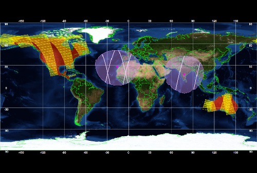
ESOV Software Tools (ESOV NG)
ESOV tool provides the means to visualise instrument swaths of all ESA EO Satellites, assist in understanding where and when satellite measurements are made and ground contact is possible.
Tools - Other
 12 June 2019
Broadview Radar Altimetry Toolbox
BRAT is an extensive tutorial on what is altimetry, techniques used and examples of usage of data; plus software to read, process and visualise altimetry data.
Tools - Analysis
 7 June 2019
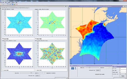
SMOS Comparison Tool
SMOS Comparison Tool (SCoT) software can be used to produce comparison plots, statistics and histograms between two SMOS products of the same type.
Tools - Visualisation
6 June 2019HEDAVI
The HEDAVI (HEritage DAta Visualisation) service enables users to discover a wealth of heritage data from ESA's ERS and Envisat missions, as well as from Landsat-5 and Landsat-7.
Tools - Visualisation
 5 June 2019
SMOS Data Viewer
SMOS Data Viewer (SDV) provides a quick and easy way to view SMOS products and the SMOS auxiliary files used for Level 1 and Level 2 product generation.
Tools - Analysis
 4 Mar 2019
VirES for Swarm
VirES adds discovery and visual analytics capabilities to the European Space Agency's online data access services established for the Swarm mission.