- All Categories (32)
- Data (6)
- News (11)
- Missions (2)
- Events (10)
- Activities (2)
- Documents (1)
Event - Workshop
URBIS24
URBan Insights from Space (URBIS24) Workshop will offer an insightful exploration of urban challenges and innovative EO-integrated solutions.
Document - Newsletter

Earth Online Newsletter 01 December 2023
This issue of the Earth Online Newsletter covers a selection of the latest news and events from ESA.
News - Data Release news
ALOS PRISM L1C European Coverage Cloud Free data collection now available for users
As part of Earthnet’s Third Party Missions Programme framework, ESA is pleased to announce that the ALOS PRISM L1C European Coverage Cloud Free data collection is now available for research purposes.
News - Data Release news
Envisat MIPAS data now available on new ESA Dissemination Server
The latest reprocessed Envisat MIPAS Level 1 and Level 2 datasets have now been migrated from simple FTP access to the new Online Dissemination service for ESA Heritage Missions (HM) Atmospheric data.
News - Infographics
Overview of the Aeolus Level-1B wind product
Learn about the Aeolus Level-1B wind product, which supports applications for the weather, atmospheric processes and climate research, in our latest infographic.
Data - Announcement of Opportunity (Restrained)

Announcement of Opportunity for SAOCOM
In cooperation with CONAE (Comisión Nacional de Actividades Espaciales), ESA is launching an Announcement of Opportunity for the international scientific community to access data from the SAOCOM mission for science and EO-based applications development.
News - Thematic area articles
How scientists use space data to help advance the energy transition
Scientists are using remote sensing data disseminated by ESA to support the green transformation of world’s power generation infrastructure.
News - Success Stories

New worldwide dataset captures the planet in fine detail
Scientists have developed an open source planetwide dataset of high-resolution Earth observation imagery, thanks to commercial data delivered by ESA’s Third Party Missions (TPM) programme.
News - Success Stories

Long-term satellite data show wind farms can affect local air currents
Decades of satellite data have allowed for the first long-term study of the impact of offshore wind farms on downstream wind flow in coastal areas.
Activity - General activities
EO Summer Schools
ESA's series of summer schools, on Monitoring of the Earth System, aims to promote the exploitation of Earth observation (EO) data.
News - Thematic area articles

How satellite data help to shape society
Data from ESA’s Earth observation archives are improving understanding of the interactions between human activities and the environment, helping to power green economic development and boosting prosperity in Europe and beyond.
Event - Training

EO Summer School 8
ESA's series of summer schools, on Monitoring of the Earth System, aims to promote the exploitation of Earth observation data.
News - Success Stories

WorldView-3 helps to track offshore methane plumes from oil and gas
Scientists have used Earth observation data to reveal enormous methane plumes spilling out from an offshore oil and gas production rig in the Gulf of Mexico. This represents a significant breakthrough in the monitoring of industrial methane emissions from space.
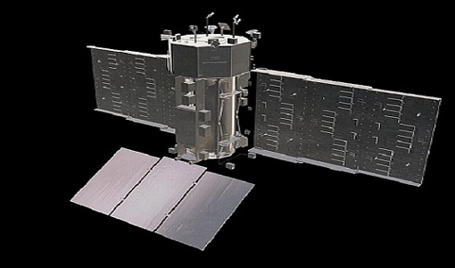
News - Infographics
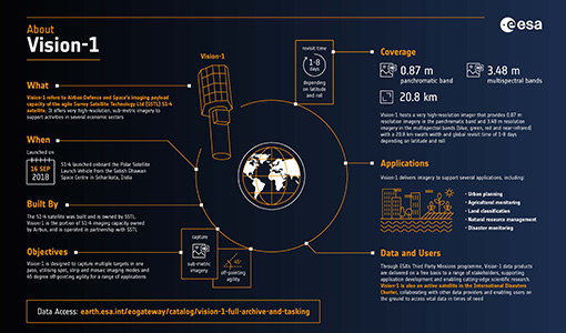
An overview of the very high-resolution Vision-1 satellite
Learn about Vision-1, which joined ESA's Third Party Missions programme in May, in our new infographic.
Data - EO Sign In Authentication (Open)
KOMPSAT-1 Coverage of 50 European Cities
Available as a single coverage collection of data over 50 European Cities acquired by KOMPSAT-1’s Electro-Optical Camera (EOC) geolocated and orthorectified. The dataset is composed by PAN imagery at 6.6 m GSD, in GeoTIFF orthorectified format.
Data - Project Proposal (Restrained)
Pléiades Neo full archive and tasking
Very High Resolution optical Pléiades Neo data at 30 cm PAN resolution (1.2 m 6-bands Multispectral) are available as part of the Airbus provision with twice daily revisit capability over the entire globe. The swath width is 14 km (footprint at nadir). Band combinations: Panchromatic one band Black & White image at 0.3 m resolution Pansharpened colour image at 0.3 m resolution: Natural colour (3 bands RGB), false colour (3 bands NIRRG), 4 bands (RGB+NIR), 6 bands Multispectral colour image in 4 bands (RGB+NIR) or 6 bands (also Deep blue and Red Edge) at 1.2 m resolution Bundle 0.3 m panchromatic image and 1.2 m multispectral image (4 or 6 bands) simultaneously acquired Geometric processing levels: Primary: The Primary product is the processing level closest to the natural image acquired by the sensor. This product restores perfect collection conditions: the sensor is placed in rectilinear geometry, and the image is clear of all radiometric distortion. Projected: The products are mapped onto the Earth cartographic system using a standard reference datum and projection system at a constant terrestrial altitude, relative to the reference ellipsoid. Ortho: The Ortho product is a georeferenced image in Earth geometry, corrected from acquisition and terrain off-nadir effects. All details about the data provision, data access conditions and quota assignment procedure are described in the Terms of Applicability available in the Resources section. As per ESA policy, very high-resolution imagery of conflict areas cannot be provided.
News - Success Stories
SAOCOM the Argentinean constellation with an Italian twist
Composed of two satellites launched in 2018 and 2019 respectively, the SAOCOM satellite mission, managed and operated by Argentina's Space Agency, CONAE, covers an array of applications that greatly benefit Earth observation and disaster monitoring.
Activity - Projects
Dragon Cooperation Programme
The Dragon Programme focussed on science and applications development in China using mainly data from the ERS and Envisat missions. The Prgramme was a cooperation between ESA and the National Remote Sensing Centre of China.
Data - External Data (Restrained)
SAOCOM Europe data products
This collection provides access to the SAOCOM products acquired in the ASI Zone of Exclusivity, that correspond mainly to the European territory plus the international waters in front of North Africa and the Middle East, archived and catalogued in the ASI/CONAE dissemination system. ASI Zone of Exclusivity Platform SAOCOM 1A only (in future SAOCOM-1B will be added) Instrument L-Band SAR, 1.275 GHz Sensor mode STRIPMAP for data acquired at fixed azimuth steering (beam from S1 up to S10) TOPSAR for data acquired in ScanSAR like mode (Mode A, Mode B or Wide) Processing level L1A - SLC (single look complex, slat range), L1B - DI (detected image, ground range), L1C - GEC (geocoded on ellipsoid), L1D - GTC (geocoded on DEM) Resolution STRIPMAP: 10m TOPSAR Narrow: 30 - 50m TOPSAR WIDE: 50 - 100m Swath Width STRIPMAP: 20 - 40 km TOPSAR Narrow: 100 - 150 km TOPSAR Wide: 220 - 350 km Polarization Single polarization (HH or VV) only for STRIPMAP Double polarization (HHHV or VHVV) for both STRIPMAP and TOPSAR Quad Polarization for both STRIPMAP and TOPSAR
Event - Workshop

Fringe 1996 Workshop
The workshop on ERS SAR Interferometry was open to scientists and students working in the field of Synthetic Aperture Radar (SAR) interferometry and its applications.