- Activities
- MUltisource data package tools...
MUltisource data package tools and SErvices (MUSE)
Overview
The continuously increasing amount of satellite data and their use, is a demanding task for the scientific community. The real challenges in access and use of these data are their volume and variety. Tools are needed to be able to rapidly and trustfully identify products, which are available in a specific region and timeframe, and to prepare these data into a format that is ready to be used. Therefore, there is the need of an “intelligent” packaging tool to subset (in space and time) the nessesary data, tailored to the end users’ needs. Such a packaging, called the Data-Agnostic Fusion Tool (DAFT), will be implemented and tested in the MUSE (Multisource data package tools and SErvices) project. The project is led by the private company SISTEMA, in cooperation with the National Meteorological Service of Austria (ZAMG) and the International Institute for Applied Systems Analysis (IIASA), and the Paris Lodron Universität Salzburg (PLUS).
Project duration: The project kicked-off in mid-January 2022, and is expected to run for 18 months.
While the overall objective of MUSE is to develop and integrate a tool to simultaneously manipulate geospatial data products, satellite, model and in-situ data, the goal of the project is threefold.
- The technical aspect includes the operationalization of the data packaging processing pipeline, the connection to various operational data sources, and the deployment on different environments, including the ESA Payload Data Ground Segment (PDGS).
- Thematically, to demonstrate the maturity and the flexibility of the tool, three thematic scenarios are implemented (see Scenarios).
- The third scope is of commercial nature. Based on the direct interaction with expert users and stakeholders which are involved in the conduction of the three scenarios, it is envisaged to derive dedicated services for operational scenarios. The integration of the data packaging tool within the operational ESA PDGS infrastructure, ensuring operation, maintenance and evolution activities and the possibility to include the module in dedicated thematic platforms is another aspect of the commercial scope of this project.
Scenarios
Stakeholders play a crucial role within the MUSE project, as they define the requirements from which dedicated services will be developed and deployed. Three scenarios were selected to demonstrate the capabilities and maturity of the project’s development. They cover the topics of aviation, green house gases (GHG) from fires and biomass change.
Scenario I – Aviation
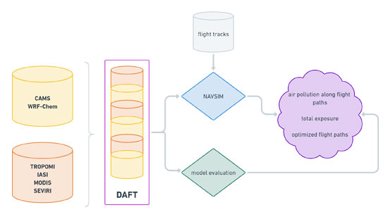
CAMS and WRF-Chem model output as well as remotely-sensed observational data are used as input. DAFT is used for spatial and temporal homogenization of all observational and modelling data sets. Using model data on flight levels as well as information about European and global flight tracks, the air traffic simulator NAVSIM calculates air pollution along flight paths and total exposure of air pollution. If critical air pollution levels are expected (e.g., after a volcanic eruption), NAVSIM calculates optimized flight paths to minimize the negative impact of aerosols and SO2 on the aircraft and their engines.
In parallel, the model output is validated with observational data from different satellite instruments (i.e., TROPOMI, MODIS, IASI, and SEVIRI). This allows the customer to better understand the validity of model-derived results of the scenario.
Scenario II – GHG from fires
The scenario service aims at estimating fire emissions, making use of three main elements:
- Satellite data to monitor the emissions of on-going wildfires
- Fire evolution model, to estimate the evolution of fires (FLAM)
- Emission estimation models, to assess the expected emissions from on-going fires (WRF-Chem)
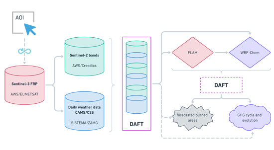
Based on a user-defined AOI, the Sentinel-3 Fire Radiative Power product is continuously checked. Once a thermal anomaly is found, daily weather data, biomass maps (potential fuel) and relevant climate indicators are extracted from existing repositories. The extracted data are passed to the DAFT to be homogenized (in space), packed and prepared for FLAM. The FLAM output is then passed to WRF-Chem, together with the initial DAFT output. In case the two model runs have a different spatial resolution, DAFT is used to merge the FLAM and WRF-Chem output to generate forecasted burned areas and the GHG cycle (emission, dispersion, removal) and evolution. The output of the initial DAFT run is used to verify the final products.
Scenario III – Biomass monitoring
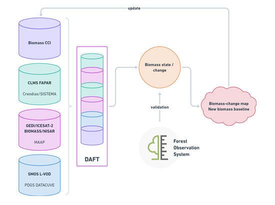
The scenario aims at assessing biomass layer changes at regional/continental level, fusing together observational data with in-situ measurements, which allows to obtain periodic global accounting of the biomass amount and fluxes. The baseline for the biomass assessment will be derived from the ESA CCI Biomass project, which has a spatial resolution of 1 km and provides global maps of above ground biomass for four epochs. Biomass related information from satellite sensors used within this scenario are the following:
- Copernicus Land Monitoring Service, Fraction of Absorbed Photosynthetically Active Radiation (FAPAR), Sentinel-3 OLCI
- GEDI, attached to the ISS
- ICESAT-2
DAFT will be used to fuse together baseline information (ESA CCI Biomass) and most recent satellite-based information, to generate change maps. The resulting layer is validated as much as possible with existing ground truth information, e.g., FOS, (Forest Observation System). Two layers are the result of the validation:
- Biomass-change map
- New biomass baseline
Once ESA's Biomass and NISAR (NASA/JAXA) products will be available through the Multi-Mission Algorithm and Analysis Platform (MAAP), the service will automatically pick the new data source(s) and fuse them together with the existing data to improve the result accuracy.